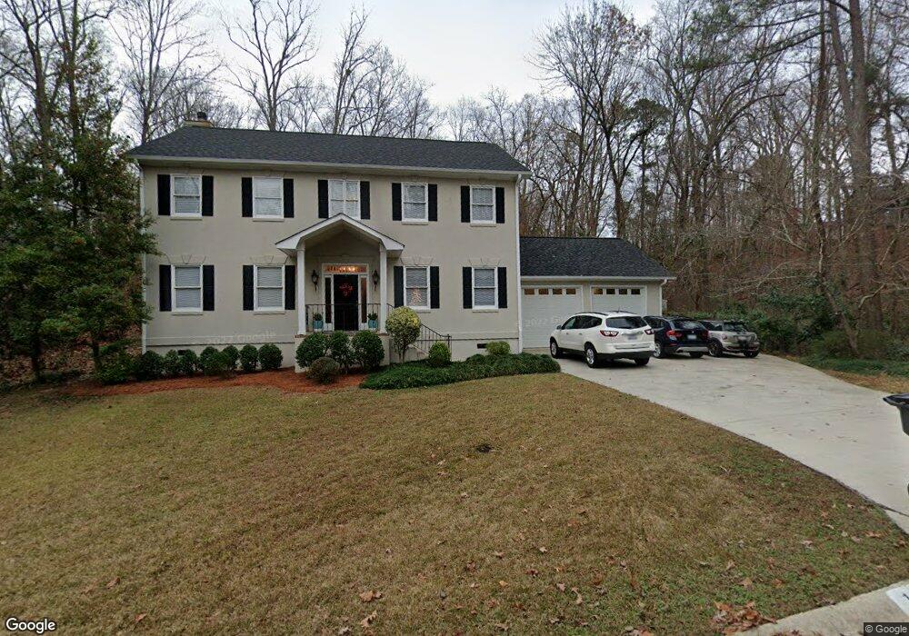
112 Eagle Nest Trail West Columbia, SC 29169
Estimated Value: $410,670 - $496,000
3
Beds
3
Baths
2,932
Sq Ft
$154/Sq Ft
Est. Value
About This Home
This home is located at 112 Eagle Nest Trail, West Columbia, SC 29169 and is currently estimated at $450,418, approximately $153 per square foot. 112 Eagle Nest Trail is a home located in Lexington County with nearby schools including Riverbank Elementary, Northside Middle, and Brookland-Cayce High School.
Ownership History
Date
Name
Owned For
Owner Type
Purchase Details
Closed on
Feb 9, 2024
Sold by
Thomas Danny L and Thomas Nancy S
Bought by
Thomas Danny L and Thomas Nancy S
Current Estimated Value
Purchase Details
Closed on
Mar 30, 2001
Sold by
Lyons Kenneth L
Bought by
Thomas Danny L
Create a Home Valuation Report for This Property
The Home Valuation Report is an in-depth analysis detailing your home's value as well as a comparison with similar homes in the area
Home Values in the Area
Average Home Value in this Area
Purchase History
| Date | Buyer | Sale Price | Title Company |
|---|---|---|---|
| Thomas Danny L | -- | South Carolina Title | |
| Thomas Danny L | $190,120 | -- |
Source: Public Records
Tax History Compared to Growth
Tax History
| Year | Tax Paid | Tax Assessment Tax Assessment Total Assessment is a certain percentage of the fair market value that is determined by local assessors to be the total taxable value of land and additions on the property. | Land | Improvement |
|---|---|---|---|---|
| 2024 | $1,453 | $10,256 | $2,000 | $8,256 |
| 2023 | $1,453 | $10,256 | $2,000 | $8,256 |
| 2022 | $1,455 | $10,256 | $2,000 | $8,256 |
| 2020 | $1,447 | $10,256 | $2,000 | $8,256 |
| 2019 | $1,406 | $9,755 | $1,600 | $8,155 |
| 2018 | $1,425 | $9,755 | $1,600 | $8,155 |
| 2017 | $1,371 | $9,755 | $1,600 | $8,155 |
| 2016 | $1,409 | $9,755 | $1,600 | $8,155 |
| 2014 | $937 | $9,514 | $1,600 | $7,914 |
| 2013 | -- | $9,510 | $1,600 | $7,910 |
Source: Public Records
Map
Nearby Homes
- 0 Quail Hollow Ln
- 2420 Feather Run Trail
- 2225 Quail Hollow Ct
- 203 Holly Ridge Ln
- 106 Meadowview Ct
- 2637 Pine Lake Dr
- 119 Meadowview Ct
- 227 Holly Ridge Ln
- 1208 Bush River Rd Unit G6
- 1208 Bush River Rd Unit r12
- 1208 Bush River Rd Unit H5
- 1208 Bush River Rd Unit J7
- 1208 Bush River Rd Unit H11
- 1208 Bush River Rd Unit P2
- 1208 Bush River Rd Unit H9
- 1208 Bush River Rd Unit C12
- 1208 Bush River Rd Unit P1
- 1208 Bush River Rd Unit P-6
- 1208 Bush River Rd Unit G3
- 1208 Bush River Rd Unit E9
- 108 Eagle Nest Trail
- 103 Boulder Top Ct
- 101 Boulder Top Ct
- 100 Eagle Nest Trail
- 107 Boulder Top Ct
- 113 Eagle Nest Trail
- 111 Eagle Nest Trail
- 107 Eagle Nest Trail
- 105 Eagle Nest Trail
- 117 Eagle Nest Trail
- 100 Boulder Top Ct
- 109 Boulder Top Ct
- 2612 Quail Hollow Ln
- 106 Boulder Top Ct
- 134 Blackhawk Trail
- 114 Holly Ridge Ln
- 118 Holly Ridge Ln
- 126 Blackhawk Trail
- 114 Blackhawk Trail
- 2600 Quail Hollow Ln