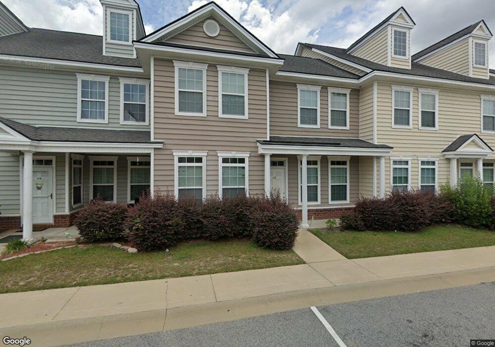
112 Governors Blvd Hinesville, GA 31313
Estimated Value: $197,000 - $222,000
3
Beds
3
Baths
1,742
Sq Ft
$121/Sq Ft
Est. Value
About This Home
This home is located at 112 Governors Blvd, Hinesville, GA 31313 and is currently estimated at $210,542, approximately $120 per square foot. 112 Governors Blvd is a home located in Liberty County with nearby schools including Waldo Pafford Elementary School, Lewis Frasier Middle School, and Bradwell Institute.
Ownership History
Date
Name
Owned For
Owner Type
Purchase Details
Closed on
Mar 7, 2008
Sold by
Black Bucket Construction
Bought by
Harvey Lashunda
Current Estimated Value
Home Financials for this Owner
Home Financials are based on the most recent Mortgage that was taken out on this home.
Original Mortgage
$174,900
Outstanding Balance
$108,256
Interest Rate
5.62%
Mortgage Type
New Conventional
Estimated Equity
$102,286
Purchase Details
Closed on
Sep 13, 2006
Sold by
Black Bucket Enterprises Llc
Bought by
Black Bucket Construction Llc
Create a Home Valuation Report for This Property
The Home Valuation Report is an in-depth analysis detailing your home's value as well as a comparison with similar homes in the area
Home Values in the Area
Average Home Value in this Area
Purchase History
| Date | Buyer | Sale Price | Title Company |
|---|---|---|---|
| Harvey Lashunda | $174,900 | -- | |
| Black Bucket Construction Llc | $585,000 | -- |
Source: Public Records
Mortgage History
| Date | Status | Borrower | Loan Amount |
|---|---|---|---|
| Open | Harvey Lashunda | $174,900 |
Source: Public Records
Tax History Compared to Growth
Tax History
| Year | Tax Paid | Tax Assessment Tax Assessment Total Assessment is a certain percentage of the fair market value that is determined by local assessors to be the total taxable value of land and additions on the property. | Land | Improvement |
|---|---|---|---|---|
| 2024 | $3,664 | $74,591 | $6,000 | $68,591 |
| 2023 | $3,664 | $65,038 | $6,000 | $59,038 |
| 2022 | $2,472 | $53,047 | $6,000 | $47,047 |
| 2021 | $2,307 | $48,566 | $6,000 | $42,566 |
| 2020 | $2,173 | $45,302 | $6,000 | $39,302 |
| 2019 | $1,926 | $40,406 | $6,000 | $34,406 |
| 2018 | $1,933 | $40,784 | $6,000 | $34,784 |
| 2017 | $1,124 | $34,130 | $6,000 | $28,130 |
| 2016 | $1,559 | $34,432 | $6,000 | $28,432 |
| 2015 | $1,640 | $34,432 | $6,000 | $28,432 |
| 2014 | $1,640 | $35,862 | $6,000 | $29,862 |
| 2013 | -- | $45,081 | $9,600 | $35,481 |
Source: Public Records
Map
Nearby Homes
- 225 Rendell Ln
- 307 Lumpkin Ln
- 269 Brightleaf Cir
- 2563 Zachary Ct
- 2716 Java Ct
- 110 Brightleaf Cir
- 24 Daylily Ct
- 34 Daylily Ct
- 206 Brightleaf Cir
- 185 Brightleaf Cir
- 302 Largo Ct
- 78 Daylily Ct
- 0 Curtis Rd Unit 163007
- 0 Curtis Rd Unit SA339536
- 644 Piedmont Ave
- 266 Brightleaf Cir
- 572 Brightleaf Cir
- 470 Brightleaf Cir
- 0 Airport Rd Unit 325633
- 426 Brightleaf Cir
- 114 Governors Blvd
- 110 Governors Blvd
- 116 Governors Blvd
- 108 Governors Blvd
- 205 Telfair Dr
- 106 Governors Blvd
- 3 Lots Governors Blvd
- Lot 8 Governors Blvd
- 209 Telfair Dr
- 209 Telfair Dr Unit 4
- 120 Governors Blvd
- 203 Riley Ln
- 104 Governors Blvd
- 207 Telfair Dr
- 207 Telfair Dr Unit 3
- 207 Telfair Dr Unit 1
- 225 Telfair Dr
- 225 Telfair Dr Unit 9
- 122 Governors Blvd
- 113 Governors Blvd