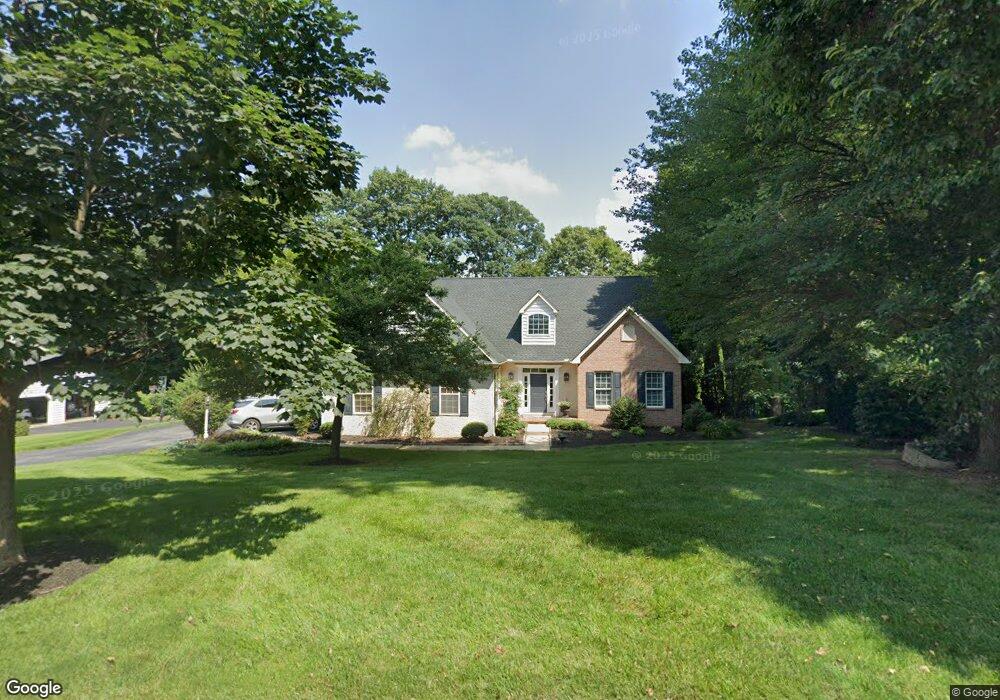
112 Hillside Ln Kennett Square, PA 19348
Estimated Value: $620,000 - $778,000
3
Beds
3
Baths
2,760
Sq Ft
$253/Sq Ft
Est. Value
About This Home
This home is located at 112 Hillside Ln, Kennett Square, PA 19348 and is currently estimated at $697,853, approximately $252 per square foot. 112 Hillside Ln is a home located in Chester County with nearby schools including Kennett Middle School, Kennett High School, and St. Patrick School.
Ownership History
Date
Name
Owned For
Owner Type
Purchase Details
Closed on
Mar 15, 1995
Sold by
The Bancroft Woods Company
Bought by
Pizzini Lucio R and Pizzini Catherine C
Current Estimated Value
Home Financials for this Owner
Home Financials are based on the most recent Mortgage that was taken out on this home.
Original Mortgage
$169,600
Interest Rate
8.89%
Create a Home Valuation Report for This Property
The Home Valuation Report is an in-depth analysis detailing your home's value as well as a comparison with similar homes in the area
Home Values in the Area
Average Home Value in this Area
Purchase History
| Date | Buyer | Sale Price | Title Company |
|---|---|---|---|
| Pizzini Lucio R | $213,598 | -- |
Source: Public Records
Mortgage History
| Date | Status | Borrower | Loan Amount |
|---|---|---|---|
| Closed | Pizzini Lucio R | $169,600 |
Source: Public Records
Tax History Compared to Growth
Tax History
| Year | Tax Paid | Tax Assessment Tax Assessment Total Assessment is a certain percentage of the fair market value that is determined by local assessors to be the total taxable value of land and additions on the property. | Land | Improvement |
|---|---|---|---|---|
| 2025 | $7,423 | $185,340 | $44,180 | $141,160 |
| 2024 | $7,423 | $185,340 | $44,180 | $141,160 |
| 2023 | $7,174 | $185,340 | $44,180 | $141,160 |
| 2022 | $7,069 | $185,340 | $44,180 | $141,160 |
| 2021 | $6,998 | $185,340 | $44,180 | $141,160 |
| 2020 | $6,865 | $185,340 | $44,180 | $141,160 |
| 2019 | $6,772 | $185,340 | $44,180 | $141,160 |
| 2018 | $6,666 | $185,340 | $44,180 | $141,160 |
| 2017 | $6,529 | $185,340 | $44,180 | $141,160 |
| 2016 | $735 | $185,340 | $44,180 | $141,160 |
| 2015 | $735 | $185,340 | $44,180 | $141,160 |
| 2014 | $735 | $185,340 | $44,180 | $141,160 |
Source: Public Records
Map
Nearby Homes
- 131 Foragers Ln
- 156 Bancroft Rd Unit CARLTON
- 156 Bancroft Rd Unit SUTTON
- 156 Bancroft Rd Unit SGR
- 156 Bancroft Rd Unit CARLTON GRND
- 107 Foragers Ln
- 103 Foragers Ln
- 13 Tullow Hill Dr
- 15 Tullow Hill Dr
- 9 Tullow Hill Dr
- 5 Tullow Hill Dr
- 1265 W Baltimore Pike
- 250 Kestrel Ct
- Augusta Plan at Stonebridge at Longwood
- Hawthorne Plan at Stonebridge at Longwood
- Magnolia Plan at Enclave at Tattersall
- Woodford Plan at Stonebridge at Longwood
- Kipling Plan at Stonebridge at Longwood
- Devonshire Plan at Enclave at Tattersall
- Ethan Plan at Stonebridge at Longwood
- 118 Hillside Ln
- 106 Hillside Ln
- 115 Hillside Ln
- 121 Hillside Ln
- 124 Hillside Ln
- 100 Hillside Ln
- 109 Hillside Ln
- 127 Hillside Ln
- 103 Hillside Ln
- 130 Hillside Ln
- 133 Hillside Ln
- 126 Bancroft Rd
- 128 Bancroft Rd
- 110 Crestview Dr
- 100 Crestview Dr
- 136 Hillside Ln
- 120 Crestview Dr
- 145 Hillside Ln
- 130 Crestview Dr
- 162 Bancroft Rd Unit 36482741