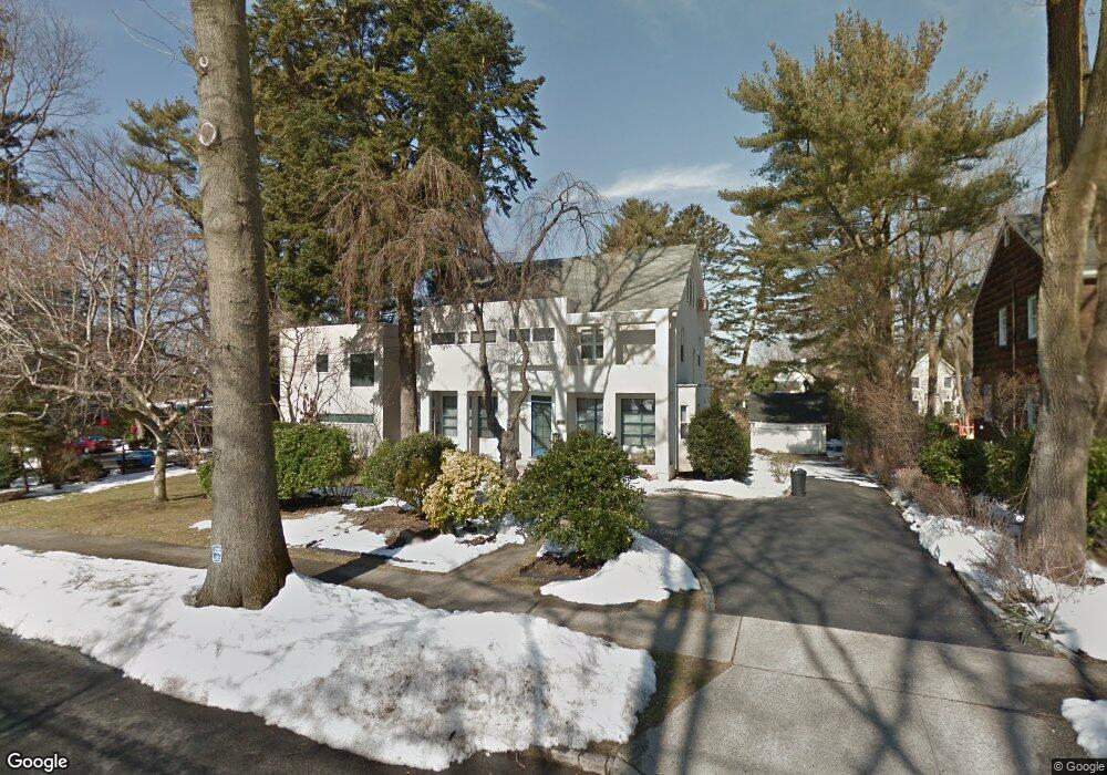
112 Huntington Rd Port Washington, NY 11050
Estimated Value: $2,092,000 - $2,225,797
4
Beds
3
Baths
3,493
Sq Ft
$618/Sq Ft
Est. Value
About This Home
This home is located at 112 Huntington Rd, Port Washington, NY 11050 and is currently estimated at $2,158,899, approximately $618 per square foot. 112 Huntington Rd is a home located in Nassau County with nearby schools including John Philip Sousa Elementary School, Carrie Palmer Weber Middle School, and Paul D. Schreiber Senior High School.
Ownership History
Date
Name
Owned For
Owner Type
Purchase Details
Closed on
Jan 30, 2017
Sold by
Narofsky Patricia A and Beecher Laura
Bought by
Eustace Stephen and Ferrante Angela
Current Estimated Value
Purchase Details
Closed on
Mar 23, 1998
Create a Home Valuation Report for This Property
The Home Valuation Report is an in-depth analysis detailing your home's value as well as a comparison with similar homes in the area
Home Values in the Area
Average Home Value in this Area
Purchase History
| Date | Buyer | Sale Price | Title Company |
|---|---|---|---|
| Eustace Stephen | $1,150,000 | None Available | |
| Eustace Stephen | $1,150,000 | None Available | |
| Eustace Stephen | $1,150,000 | None Available | |
| -- | -- | -- | |
| -- | -- | -- |
Source: Public Records
Tax History Compared to Growth
Tax History
| Year | Tax Paid | Tax Assessment Tax Assessment Total Assessment is a certain percentage of the fair market value that is determined by local assessors to be the total taxable value of land and additions on the property. | Land | Improvement |
|---|---|---|---|---|
| 2025 | $28,035 | $1,244 | $666 | $578 |
| 2024 | $8,005 | $1,360 | $693 | $667 |
| 2023 | $25,226 | $1,418 | $723 | $695 |
| 2022 | $25,226 | $1,444 | $809 | $635 |
| 2021 | $22,794 | $1,363 | $658 | $705 |
| 2020 | $17,000 | $1,530 | $1,031 | $499 |
| 2019 | $20,709 | $1,639 | $1,104 | $535 |
| 2018 | $20,867 | $2,350 | $0 | $0 |
| 2017 | $17,051 | $2,350 | $1,583 | $767 |
| 2016 | $25,782 | $2,350 | $1,583 | $767 |
| 2015 | $8,190 | $2,264 | $1,583 | $681 |
| 2014 | $8,190 | $2,264 | $1,583 | $681 |
| 2013 | $7,695 | $2,264 | $1,583 | $681 |
Source: Public Records
Map
Nearby Homes
- 0 Route 5 & 20
- 454 Main St
- 96 Davis Rd
- 1 Luquer Rd
- 47 Carlton Ave
- 74 Bayview Ave Unit A
- 28 Charles St
- 43 Amherst Rd
- 18 S Washington St
- 17 Willow Dr
- 38 Madison St Unit 38L
- 2 Smull Ln
- 372 Main St Unit 105
- 113 Murray Ave
- 100 Gristmill Ln
- 34 Davis Rd
- 22 Franklin Ave
- 125 Main St Unit 1T
- 125 Main St Unit 2H
- 35 Evergreen Ave
- 110 Huntington Rd
- 3 Huntington Rd
- 12 Reid Ave
- 10 Reid Ave
- 14 Reid Ave
- 8 Huntington Rd
- 16 Reid Ave
- 24 N Plandome Rd
- 20 N Plandome Rd
- 12 Huntington Rd
- 20 Reid Ave
- 2 Reid Ave
- 11 Huntington Rd
- 104 Huntington Rd
- 115 Huntington Rd
- 111 Huntington Rd
- 116 Huntington Rd
- 9 Huntington Rd
- 11 Reid Ave
- 102 Huntington Rd