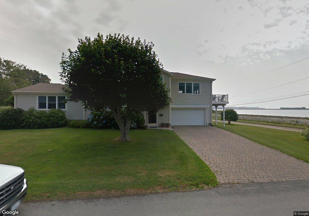
112 Kay Blvd Newport, RI 02840
Eustis-Easton's Pond NeighborhoodEstimated Value: $1,303,000 - $1,605,210
2
Beds
3
Baths
2,724
Sq Ft
$543/Sq Ft
Est. Value
About This Home
This home is located at 112 Kay Blvd, Newport, RI 02840 and is currently estimated at $1,477,803, approximately $542 per square foot. 112 Kay Blvd is a home located in Newport County with nearby schools including Rogers High School, St Michael's Country Day School, and St George's School.
Ownership History
Date
Name
Owned For
Owner Type
Purchase Details
Closed on
Jul 23, 2021
Sold by
Winter Sheila M and Sammons Karen E
Bought by
Sammons Winter Irt
Current Estimated Value
Purchase Details
Closed on
Sep 15, 1980
Bought by
Winter Sheila M and Sammons Karen E
Create a Home Valuation Report for This Property
The Home Valuation Report is an in-depth analysis detailing your home's value as well as a comparison with similar homes in the area
Home Values in the Area
Average Home Value in this Area
Purchase History
| Date | Buyer | Sale Price | Title Company |
|---|---|---|---|
| Sammons Winter Irt | -- | None Available | |
| Winter Sheila M | -- | -- |
Source: Public Records
Mortgage History
| Date | Status | Borrower | Loan Amount |
|---|---|---|---|
| Previous Owner | Winter Sheila M | $75,000 | |
| Previous Owner | Winter Sheila M | $135,000 | |
| Previous Owner | Winter Sheila M | $250,000 |
Source: Public Records
Tax History Compared to Growth
Tax History
| Year | Tax Paid | Tax Assessment Tax Assessment Total Assessment is a certain percentage of the fair market value that is determined by local assessors to be the total taxable value of land and additions on the property. | Land | Improvement |
|---|---|---|---|---|
| 2025 | $8,625 | $1,201,200 | $664,200 | $537,000 |
| 2024 | $8,372 | $1,201,200 | $664,200 | $537,000 |
| 2023 | $7,502 | $756,300 | $399,100 | $357,200 |
| 2022 | $7,268 | $756,300 | $399,100 | $357,200 |
| 2021 | $7,056 | $756,300 | $399,100 | $357,200 |
| 2020 | $6,546 | $636,800 | $297,300 | $339,500 |
| 2019 | $6,546 | $636,800 | $297,300 | $339,500 |
| 2018 | $7,558 | $756,600 | $356,700 | $399,900 |
| 2017 | $5,502 | $490,800 | $210,000 | $280,800 |
| 2016 | $5,364 | $490,800 | $210,000 | $280,800 |
| 2015 | $5,237 | $490,800 | $210,000 | $280,800 |
| 2014 | $6,126 | $508,000 | $195,600 | $312,400 |
Source: Public Records
Map
Nearby Homes
- 78 Ellery Rd
- 129 Bliss Mine Rd
- 36 Kay Blvd
- 128 Eustis Ave
- 103 Champlin Place N
- 198 Gibbs Ave
- 8 Champlin St
- 55 Hunter Ave
- 78 Rhode Island Ave Unit 6
- 78 Rhode Island Ave Unit 8
- 5 Gardiner St
- 17 Lincoln St
- 19 Princeton St Unit 21
- 1 Shangri-La Ln
- 55 John Clarke Rd Unit 8
- 55 John Clarke Rd Unit 3
- 1 Arnold Ave
- 5 Elliot Place
- 4 Newport Ave Unit B2
- 5 Pell St