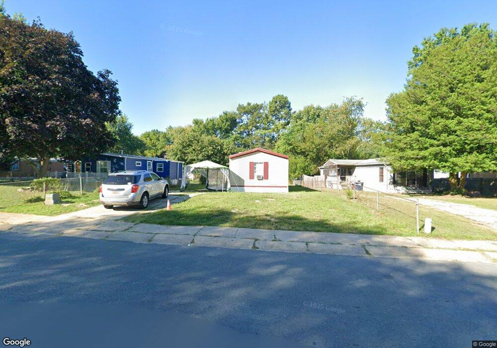
112 Lakeside Dr North East, MD 21901
Estimated Value: $51,332 - $271,000
--
Bed
2
Baths
768
Sq Ft
$179/Sq Ft
Est. Value
About This Home
This home is located at 112 Lakeside Dr, North East, MD 21901 and is currently estimated at $137,111, approximately $178 per square foot. 112 Lakeside Dr is a home located in Cecil County with nearby schools including Bay View Elementary School, North East Middle School, and North East High School.
Ownership History
Date
Name
Owned For
Owner Type
Purchase Details
Closed on
Aug 3, 2007
Sold by
Lurty David W and Lurty Susan K
Bought by
Lakeside Sales Llc
Current Estimated Value
Purchase Details
Closed on
Jul 31, 2007
Sold by
Lurty David W and Lurty Susan K
Bought by
Lakeside Sales Llc
Purchase Details
Closed on
Oct 10, 2006
Sold by
Lurty William B and Lurty Evelyn D
Bought by
Lurty David W and Lurty Susan K
Purchase Details
Closed on
Jul 6, 1979
Sold by
Rothauge Arthur E
Bought by
Lurty William B and Lurty Evelyn D
Create a Home Valuation Report for This Property
The Home Valuation Report is an in-depth analysis detailing your home's value as well as a comparison with similar homes in the area
Home Values in the Area
Average Home Value in this Area
Purchase History
| Date | Buyer | Sale Price | Title Company |
|---|---|---|---|
| Lakeside Sales Llc | $35,000 | -- | |
| Lakeside Sales Llc | $35,000 | -- | |
| Lurty David W | -- | -- | |
| Lurty William B | $20,900 | -- |
Source: Public Records
Tax History Compared to Growth
Tax History
| Year | Tax Paid | Tax Assessment Tax Assessment Total Assessment is a certain percentage of the fair market value that is determined by local assessors to be the total taxable value of land and additions on the property. | Land | Improvement |
|---|---|---|---|---|
| 2025 | $131 | $12,000 | $12,000 | $0 |
| 2024 | $131 | $12,000 | $12,000 | $0 |
| 2023 | $133 | $12,000 | $12,000 | $0 |
| 2022 | $274 | $24,333 | $0 | $0 |
| 2021 | $273 | $23,967 | $0 | $0 |
| 2020 | $272 | $23,600 | $12,000 | $11,600 |
| 2019 | $272 | $23,600 | $12,000 | $11,600 |
| 2018 | $272 | $23,600 | $12,000 | $11,600 |
| 2017 | $300 | $27,200 | $0 | $0 |
| 2016 | $300 | $27,200 | $0 | $0 |
| 2015 | $300 | $27,200 | $0 | $0 |
| 2014 | $453 | $33,100 | $0 | $0 |
Source: Public Records
Map
Nearby Homes
- 0 Pulaski Hwy
- 2515 Pulaski Hwy
- 162 Razor Strap Rd
- 10 Trail Wood Ct
- 51 Hickory Dr
- 29 Aspen Dr
- 9 Aspen Dr
- Coral Plan at Northwoods - Seasons
- 31 Poplar Ct
- Lapis Plan at Northwoods - Seasons
- 80 Catalpa Dr
- Pearl Plan at Northwoods - Seasons
- 10 Poplar Ct
- 9 Poplar Ct
- 34 Poplar Ct
- 17 Poplar Ct
- 18 Poplar Ct
- Moonstone Plan at Northwoods - Seasons
- 35 Catalpa Dr
- 37 Aspen Dr
- 110 Lakeside Dr
- 114 Lakeside Dr
- 108 Lakeside Dr
- 106 Lakeside Dr
- 101 Victoria Ct
- 116 Lakeside Dr
- 118 Lakeside Dr
- 425 Razor Strap Rd
- 104 Lakeside Dr
- 102 Victoria Ct
- 104 W Huron Ct
- 105 W Huron Ct
- 106 W Huron Ct
- 111 Lakeside Dr
- 423 Razor Strap Rd
- 109 Lakeside Dr
- 107 Lakeside Dr
- 103 W Huron Ct
- 105 Lakeside Dr
- 421 Razor Strap Rd