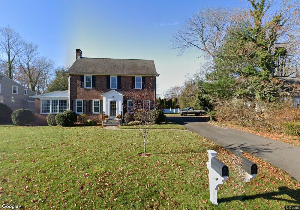
112 Maple Ave North Haven, CT 06473
Estimated Value: $423,602 - $488,000
3
Beds
2
Baths
1,760
Sq Ft
$261/Sq Ft
Est. Value
About This Home
This home is located at 112 Maple Ave, North Haven, CT 06473 and is currently estimated at $459,651, approximately $261 per square foot. 112 Maple Ave is a home located in New Haven County with nearby schools including North Haven High School.
Ownership History
Date
Name
Owned For
Owner Type
Purchase Details
Closed on
Nov 15, 2024
Sold by
Anderson William K and Anderson Kim S
Bought by
Anderson William K and Anderson Kim S
Current Estimated Value
Purchase Details
Closed on
Apr 16, 1997
Sold by
Pitcher Donald T and Pitcher Barbara K
Bought by
Anderson William K and Anderson Kim S
Create a Home Valuation Report for This Property
The Home Valuation Report is an in-depth analysis detailing your home's value as well as a comparison with similar homes in the area
Home Values in the Area
Average Home Value in this Area
Purchase History
| Date | Buyer | Sale Price | Title Company |
|---|---|---|---|
| Anderson William K | -- | None Available | |
| Anderson William K | -- | None Available | |
| Anderson William K | $135,000 | -- | |
| Anderson William K | $135,000 | -- |
Source: Public Records
Mortgage History
| Date | Status | Borrower | Loan Amount |
|---|---|---|---|
| Previous Owner | Anderson William K | $165,000 | |
| Previous Owner | Anderson William K | $111,500 | |
| Previous Owner | Anderson William K | $58,000 |
Source: Public Records
Tax History Compared to Growth
Tax History
| Year | Tax Paid | Tax Assessment Tax Assessment Total Assessment is a certain percentage of the fair market value that is determined by local assessors to be the total taxable value of land and additions on the property. | Land | Improvement |
|---|---|---|---|---|
| 2025 | $7,335 | $248,990 | $76,300 | $172,690 |
| 2024 | $6,607 | $190,720 | $76,300 | $114,420 |
| 2023 | $6,227 | $190,720 | $76,300 | $114,420 |
| 2022 | $5,857 | $190,720 | $76,300 | $114,420 |
| 2021 | $5,857 | $190,720 | $76,300 | $114,420 |
| 2020 | $5,859 | $190,720 | $76,300 | $114,420 |
| 2019 | $6,452 | $206,920 | $66,430 | $140,490 |
| 2018 | $6,452 | $206,920 | $66,430 | $140,490 |
| 2017 | $6,328 | $206,920 | $66,430 | $140,490 |
| 2016 | $6,317 | $206,920 | $66,430 | $140,490 |
| 2015 | $6,088 | $206,920 | $66,430 | $140,490 |
| 2014 | $6,104 | $217,210 | $83,160 | $134,050 |
Source: Public Records
Map
Nearby Homes
- 5 Tennyson Ave
- 52 William St
- 93 Bailey Rd
- 137 Mulholland Way
- 11 Saint John St Unit G8
- 11 Saint John St Unit C2
- 40 Newbury Ct Unit 40
- 71 Leonardo Dr
- 101 Pool Rd
- 63 Sackett Point Rd
- 28 Fallon Dr
- 155 Mill Rd
- 38 Pine River Rd
- 24 Sherwood Dr
- 9 Russell Rd
- 1400 Hartford Turnpike Unit 25
- 40 Woodland Ave
- 15 Turner Dr
- 12 Gilbert Hill Rd
- 28 Fieldstone Ct Unit 28