A
Seller's Agent in 2016
Ann Thomas
Frison Realty & Construction Co
(229) 347-2457
43 Total Sales
Estimated Value: $269,000 - $403,000
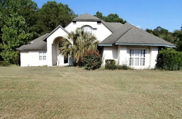
Spacious Worth County home on the market with about 2,600 square feet of living area with 4 bedrooms, 2 full bathrooms, and 2 half bathrooms.It was built in 2000 and requires a little sprucing up but it has great bones. The front of the home has huge fanned windows that can stream natural light in. There are many custom features in the home like the tiled bath tubs, vanities, and built ins. Lovely spacious kitchen with tiled island and ample counter and cabinet space. Come and tour this lovely home.
Last Agent to Sell the Property
Frison Realty & Construction Co Brokerage Phone: 2294366628 License #43940 Listed on: 11/23/2016
Last Buyer's Agent
Janice Wester
Coldwell Banker Walden & Kirkland
| Date | Buyer | Sale Price | Title Company |
|---|---|---|---|
| Hamilton Melissa S | $97,484 | -- | |
| Us Bank National Association T | $178,041 | -- | |
| Miller Harold L | -- | -- |
| Date | Status | Borrower | Loan Amount |
|---|---|---|---|
| Open | Hamilton Melissa S | $68,084 |
| Date | Event | Price | List to Sale | Price per Sq Ft |
|---|---|---|---|---|
| 12/29/2016 12/29/16 | Sold | $97,484 | -- | $37 / Sq Ft |
| 11/23/2016 11/23/16 | Pending | -- | -- | -- |
| Year | Tax Paid | Tax Assessment Tax Assessment Total Assessment is a certain percentage of the fair market value that is determined by local assessors to be the total taxable value of land and additions on the property. | Land | Improvement |
|---|---|---|---|---|
| 2024 | $2,960 | $96,326 | $2,424 | $93,902 |
| 2023 | $2,960 | $96,326 | $2,424 | $93,902 |
| 2022 | $2,948 | $95,859 | $2,424 | $93,435 |
| 2021 | $2,926 | $95,859 | $2,424 | $93,435 |
| 2020 | $2,930 | $95,859 | $2,424 | $93,435 |
| 2019 | $2,930 | $95,859 | $2,424 | $93,435 |
| 2018 | $2,746 | $95,859 | $2,424 | $93,435 |
| 2017 | $2,746 | $95,859 | $2,424 | $93,435 |
| 2016 | $2,746 | $95,859 | $2,424 | $93,435 |
| 2015 | $2,751 | $95,859 | $2,424 | $93,435 |
| 2014 | $2,751 | $95,859 | $2,424 | $93,435 |
| 2013 | -- | $95,859 | $2,424 | $93,435 |
| 2012 | -- | $95,859 | $2,424 | $93,434 |
A
Seller's Agent in 2016
Ann Thomas
Frison Realty & Construction Co
(229) 347-2457
43 Total Sales
J
Buyer's Agent in 2016
Janice Wester
Coldwell Banker Walden & Kirkland
Source: Albany Board of REALTORS®
MLS Number: 135140
APN: 00590-227-A-5
