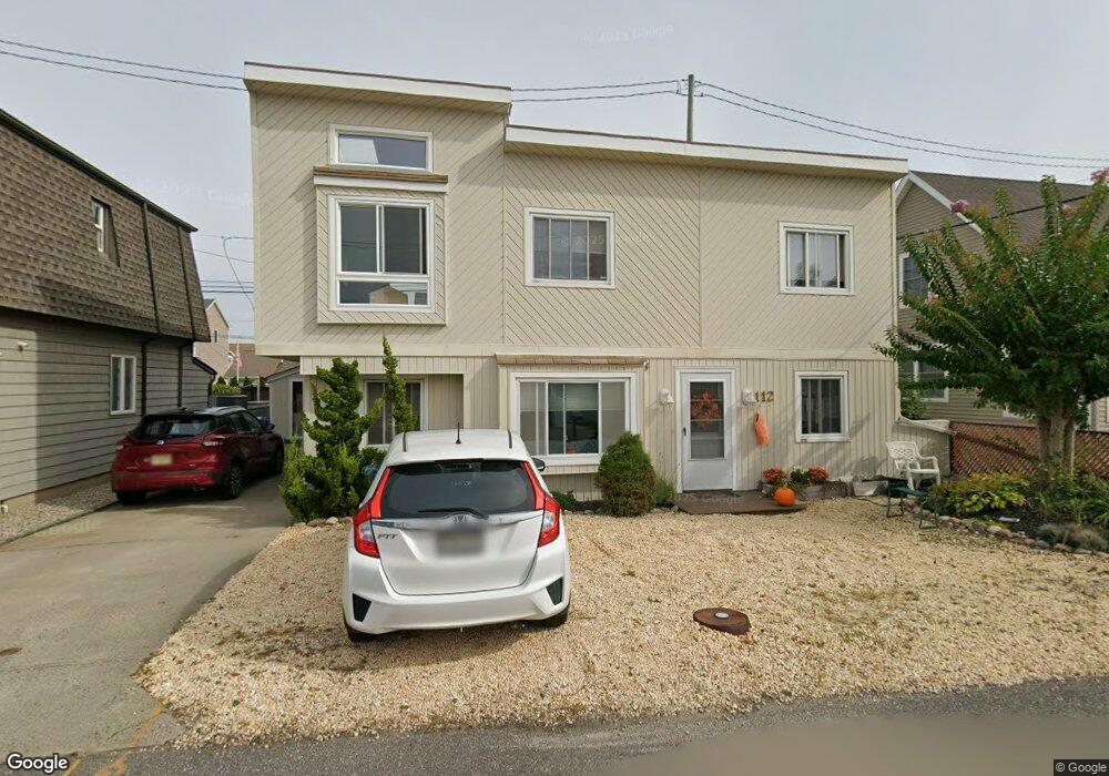
112 N Bayside Rd Lavallette, NJ 08735
Dover Beaches North NeighborhoodEstimated Value: $1,001,288 - $1,337,000
4
Beds
2
Baths
1,763
Sq Ft
$651/Sq Ft
Est. Value
About This Home
This home is located at 112 N Bayside Rd, Lavallette, NJ 08735 and is currently estimated at $1,147,072, approximately $650 per square foot. 112 N Bayside Rd is a home located in Ocean County.
Ownership History
Date
Name
Owned For
Owner Type
Purchase Details
Closed on
Oct 21, 2005
Sold by
Kilgallen John E and Kilgallen Marie C
Bought by
Kilgallen Marie C
Current Estimated Value
Purchase Details
Closed on
Aug 30, 2000
Sold by
Collett Milton
Bought by
Kilgallen John and Kilgallen Marie
Home Financials for this Owner
Home Financials are based on the most recent Mortgage that was taken out on this home.
Original Mortgage
$216,000
Outstanding Balance
$78,724
Interest Rate
8.1%
Estimated Equity
$1,068,348
Create a Home Valuation Report for This Property
The Home Valuation Report is an in-depth analysis detailing your home's value as well as a comparison with similar homes in the area
Home Values in the Area
Average Home Value in this Area
Purchase History
| Date | Buyer | Sale Price | Title Company |
|---|---|---|---|
| Kilgallen Marie C | -- | -- | |
| Kilgallen John | $270,000 | -- |
Source: Public Records
Mortgage History
| Date | Status | Borrower | Loan Amount |
|---|---|---|---|
| Open | Kilgallen John | $216,000 |
Source: Public Records
Tax History Compared to Growth
Tax History
| Year | Tax Paid | Tax Assessment Tax Assessment Total Assessment is a certain percentage of the fair market value that is determined by local assessors to be the total taxable value of land and additions on the property. | Land | Improvement |
|---|---|---|---|---|
| 2025 | $10,848 | $595,700 | $311,000 | $284,700 |
| 2024 | $10,312 | $595,700 | $311,000 | $284,700 |
| 2023 | $9,942 | $595,700 | $311,000 | $284,700 |
| 2022 | $9,942 | $595,700 | $311,000 | $284,700 |
| 2021 | $8,663 | $367,600 | $234,800 | $132,800 |
| 2020 | $9,168 | $367,600 | $234,800 | $132,800 |
| 2019 | $8,771 | $367,600 | $234,800 | $132,800 |
| 2018 | $8,653 | $367,600 | $234,800 | $132,800 |
| 2017 | $8,580 | $367,600 | $234,800 | $132,800 |
| 2016 | $8,356 | $367,600 | $234,800 | $132,800 |
| 2015 | $8,039 | $367,600 | $234,800 | $132,800 |
| 2014 | $7,653 | $367,600 | $234,800 | $132,800 |
Source: Public Records
Map
Nearby Homes
- 34 S Surf Rd
- 26 N Surf Rd
- 3420 Seaview Rd
- 37 E Flamingo Way
- 257 Strickland Blvd
- 348 Venice Dr
- 108 W Sandpiper Way
- 109 W Sandpiper Way
- 417 Delray Dr
- 3311 Seaview Rd
- 366 Fort Meyers Ct
- 545 Route 35
- 254 Harbor Ct
- 465 Boca Raton Dr
- 515 New Jersey 35
- 12 E Chadwick Way Unit 2
- 208 Mallard Ln
- 201 Mallard Ln
- 236 Gull Ln
- 18 Coronado Rd
- 116 N Bayside Rd
- 108 N Bayside Rd
- 109 W Colony Rd
- 105 W Colony Rd
- 113 W Colony Rd
- 107 N Bayside Rd
- 120 N Bayside Rd
- 104 N Bayside Rd
- 115 N Bayside Rd
- 101 W Colony Rd
- 106 W Colony Rd
- 110 W Colony Rd
- 100 N Bayside Rd
- 119 N Bayside Rd
- 102 W Colony Rd
- 117 W Colony Rd
- 124 N Bayside Rd
- 114 W Colony Rd
- 117 Bayberry Rd
- 112 S Bayside Rd