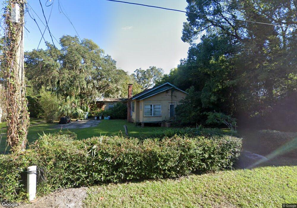
112 Oliver Ln Saint Simons Island, GA 31522
Estimated Value: $426,000 - $790,000
3
Beds
1
Bath
1,176
Sq Ft
$495/Sq Ft
Est. Value
About This Home
This home is located at 112 Oliver Ln, Saint Simons Island, GA 31522 and is currently estimated at $582,334, approximately $495 per square foot. 112 Oliver Ln is a home located in Glynn County with nearby schools including Oglethorpe Point Elementary School, Glynn Middle School, and Glynn Academy.
Ownership History
Date
Name
Owned For
Owner Type
Purchase Details
Closed on
Dec 9, 2020
Sold by
Hall Ruth M Estate
Bought by
Murray Victor L
Current Estimated Value
Purchase Details
Closed on
Jul 29, 2020
Sold by
Austin Pamela
Bought by
Murray Victor L
Purchase Details
Closed on
Jul 24, 2020
Sold by
Dickson Lance
Bought by
Murray Victor L
Purchase Details
Closed on
Jul 7, 2020
Sold by
Dickson Brian
Bought by
Murray Victor L
Purchase Details
Closed on
Jun 22, 2020
Sold by
Murray David
Bought by
Murray Victor L
Purchase Details
Closed on
Mar 14, 2005
Sold by
Murray Lorraine
Bought by
Murray Glandly and Murray David
Create a Home Valuation Report for This Property
The Home Valuation Report is an in-depth analysis detailing your home's value as well as a comparison with similar homes in the area
Home Values in the Area
Average Home Value in this Area
Purchase History
| Date | Buyer | Sale Price | Title Company |
|---|---|---|---|
| Murray Victor L | -- | -- | |
| Murray Victor L | -- | -- | |
| Murray Victor L | -- | -- | |
| Murray Victor L | -- | -- | |
| Murray Victor L | -- | -- | |
| Murray Victor L | -- | -- | |
| Murray Glandly | -- | -- |
Source: Public Records
Tax History Compared to Growth
Tax History
| Year | Tax Paid | Tax Assessment Tax Assessment Total Assessment is a certain percentage of the fair market value that is determined by local assessors to be the total taxable value of land and additions on the property. | Land | Improvement |
|---|---|---|---|---|
| 2025 | $5,399 | $215,280 | $186,880 | $28,400 |
| 2024 | $3,693 | $147,240 | $127,080 | $20,160 |
| 2023 | $1,689 | $147,240 | $127,080 | $20,160 |
| 2022 | $1,028 | $97,800 | $87,600 | $10,200 |
| 2021 | $1,056 | $53,800 | $43,800 | $10,000 |
| 2020 | $1,064 | $53,800 | $43,800 | $10,000 |
| 2019 | $1,064 | $53,800 | $43,800 | $10,000 |
| 2018 | $1,398 | $53,800 | $43,800 | $10,000 |
| 2017 | $1,398 | $53,800 | $43,800 | $10,000 |
| 2016 | $1,305 | $53,800 | $43,800 | $10,000 |
| 2015 | $1,311 | $53,800 | $43,800 | $10,000 |
| 2014 | $1,311 | $53,800 | $43,800 | $10,000 |
Source: Public Records
Map
Nearby Homes
- 101 Barkentine Ct Unit A-1
- 156 Shady Brook Cir Unit 101
- 103 Travellers Way
- 150 Shady Brook Cir Unit 201
- 109 Shady Brook Cir Unit 301
- 117 Quamley Wells Dr
- 622 Brockinton Point
- 99 Brook Dr
- 222 Walmar Grove
- 105 Brook Dr
- 104 Ashwood Way
- 116 Ashwood Way
- 146 Shady Brook Cir Unit 301
- 24 Orchard Rd
- 123 Shadow Wood Bend
- 2512 Demere Rd Unit 7
- 361 Brockinton Marsh
- 2513 Demere Rd Unit 8
- 2513 Demere Rd Unit 1
- 129 Shadow Wood Bend