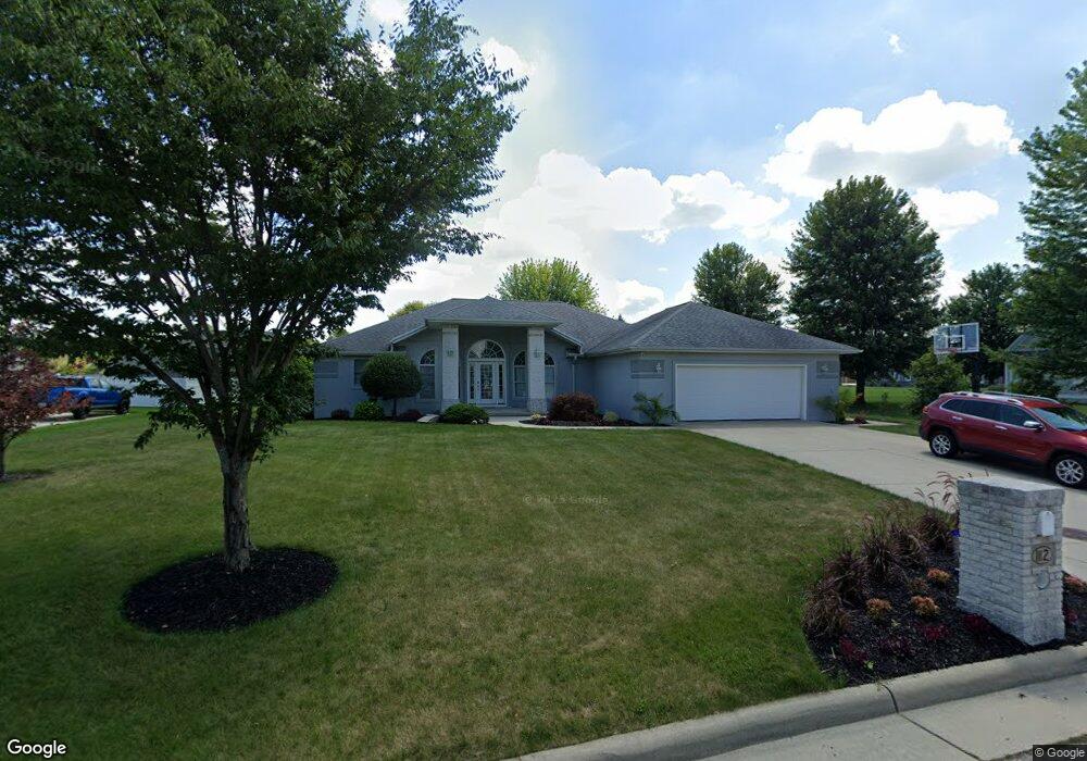
112 Pheasant Ln Archbold, OH 43502
Estimated Value: $350,147 - $414,000
3
Beds
2
Baths
2,286
Sq Ft
$166/Sq Ft
Est. Value
About This Home
This home is located at 112 Pheasant Ln, Archbold, OH 43502 and is currently estimated at $379,537, approximately $166 per square foot. 112 Pheasant Ln is a home located in Fulton County with nearby schools including Archbold Elementary School, Archbold Middle School, and Archbold High School.
Ownership History
Date
Name
Owned For
Owner Type
Purchase Details
Closed on
Jan 17, 2003
Sold by
Robert & Roger Inv Ltd
Bought by
Hogrefe Douglas G and Hogrefe Lori A
Current Estimated Value
Home Financials for this Owner
Home Financials are based on the most recent Mortgage that was taken out on this home.
Original Mortgage
$150,000
Outstanding Balance
$65,296
Interest Rate
6.3%
Mortgage Type
New Conventional
Estimated Equity
$314,241
Create a Home Valuation Report for This Property
The Home Valuation Report is an in-depth analysis detailing your home's value as well as a comparison with similar homes in the area
Home Values in the Area
Average Home Value in this Area
Purchase History
| Date | Buyer | Sale Price | Title Company |
|---|---|---|---|
| Hogrefe Douglas G | $25,000 | -- |
Source: Public Records
Mortgage History
| Date | Status | Borrower | Loan Amount |
|---|---|---|---|
| Open | Hogrefe Douglas G | $150,000 |
Source: Public Records
Tax History
| Year | Tax Paid | Tax Assessment Tax Assessment Total Assessment is a certain percentage of the fair market value that is determined by local assessors to be the total taxable value of land and additions on the property. | Land | Improvement |
|---|---|---|---|---|
| 2024 | $5,295 | $103,460 | $12,320 | $91,140 |
| 2023 | $5,345 | $103,460 | $12,320 | $91,140 |
| 2022 | $4,207 | $86,210 | $10,260 | $75,950 |
| 2021 | $4,212 | $86,210 | $10,260 | $75,950 |
| 2020 | $4,192 | $86,210 | $10,260 | $75,950 |
| 2019 | $3,910 | $76,690 | $10,260 | $66,430 |
| 2018 | $4,074 | $76,690 | $10,260 | $66,430 |
| 2017 | $4,522 | $76,690 | $10,260 | $66,430 |
| 2016 | $4,631 | $73,370 | $10,260 | $63,110 |
| 2015 | $4,156 | $73,370 | $10,260 | $63,110 |
| 2014 | $4,202 | $73,370 | $10,260 | $63,110 |
| 2013 | $4,437 | $76,060 | $10,850 | $65,210 |
Source: Public Records
Map
Nearby Homes
- 552 Quail Run
- 301 N Pointe Dr
- 328 W Lutz Rd Unit 328
- 408 Ditto St
- 404 Murbach St
- 219 E Williams St
- 0 Lafayette St
- 808 West St
- 112 Sylvanus St
- 3514 Gaslight Dr
- 1808 S Defiance St
- 224 Hawthorn Dr
- 21530 County Road A
- V-526 Co Rd 25
- 8579 County Road 23
- 4427 County Road 19
- 18857 US Highway 20a
- 23161 County Road Jk
- 17830 County Road C
- 22227 Us Highway 20a
- 108 Pheasant Ln
- 429 Primrose Ln
- 116 Pheasant Ln
- 425 Primrose Ln
- 433 Primrose Ln
- 113 Pheasant Ln
- 421 Primrose Ln
- 104 Pheasant Ln
- 437 Primrose Ln
- 109 Pheasant Ln
- 117 Pheasant Ln
- 401404 Primrose Ln
- 417 Primrose Ln
- 105 Pheasant Ln
- 124 Pheasant Ln
- 428 Primrose Ln
- 424 Primrose Ln
- 305 Quail Run
- 301 Quail Run
- 548 Quail Run
Your Personal Tour Guide
Ask me questions while you tour the home.