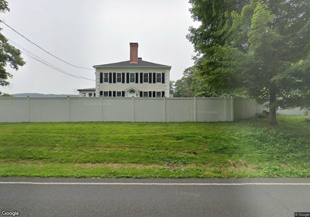
112 Route 39 N Sherman, CT 06784
Estimated Value: $749,069 - $2,264,000
2
Beds
3
Baths
2,880
Sq Ft
$408/Sq Ft
Est. Value
About This Home
This home is located at 112 Route 39 N, Sherman, CT 06784 and is currently estimated at $1,173,767, approximately $407 per square foot. 112 Route 39 N is a home located in Fairfield County with nearby schools including Sherman School.
Ownership History
Date
Name
Owned For
Owner Type
Purchase Details
Closed on
Oct 24, 2024
Sold by
Casey Kevin M and Casey Meghan M
Bought by
Juniper Mint Lane Llc
Current Estimated Value
Purchase Details
Closed on
May 10, 2005
Sold by
Lipuma Thomas A and Lipuma Gilda S
Bought by
Schuenfeld Mark R and Field Randy Scott
Home Financials for this Owner
Home Financials are based on the most recent Mortgage that was taken out on this home.
Original Mortgage
$1,310,625
Interest Rate
6.01%
Create a Home Valuation Report for This Property
The Home Valuation Report is an in-depth analysis detailing your home's value as well as a comparison with similar homes in the area
Home Values in the Area
Average Home Value in this Area
Purchase History
| Date | Buyer | Sale Price | Title Company |
|---|---|---|---|
| Juniper Mint Lane Llc | -- | None Available | |
| Juniper Mint Lane Llc | -- | None Available | |
| Schuenfeld Mark R | $1,749,500 | -- | |
| Schuenfeld Mark R | $1,749,500 | -- |
Source: Public Records
Mortgage History
| Date | Status | Borrower | Loan Amount |
|---|---|---|---|
| Previous Owner | Schuenfeld Mark R | $455,000 | |
| Previous Owner | Schuenfeld Mark R | $960,000 | |
| Previous Owner | Schuenfeld Mark R | $1,310,625 |
Source: Public Records
Tax History Compared to Growth
Tax History
| Year | Tax Paid | Tax Assessment Tax Assessment Total Assessment is a certain percentage of the fair market value that is determined by local assessors to be the total taxable value of land and additions on the property. | Land | Improvement |
|---|---|---|---|---|
| 2025 | $5,980 | $358,700 | $104,300 | $254,400 |
| 2024 | $5,868 | $358,700 | $104,300 | $254,400 |
| 2023 | $6,392 | $358,700 | $104,300 | $254,400 |
| 2022 | $6,521 | $358,700 | $104,300 | $254,400 |
| 2021 | $5,074 | $358,700 | $104,300 | $254,400 |
| 2020 | $6,855 | $358,700 | $104,300 | $254,400 |
| 2019 | $5,163 | $358,700 | $104,300 | $254,400 |
| 2018 | $0 | $362,600 | $109,000 | $253,600 |
| 2017 | $5,115 | $362,600 | $109,000 | $253,600 |
| 2016 | $7,372 | $362,600 | $108,990 | $253,610 |
| 2015 | $7,267 | $362,600 | $108,990 | $253,610 |
| 2014 | $8,336 | $420,140 | $108,990 | $311,150 |
Source: Public Records
Map
Nearby Homes
- 00 Anderson Rd
- 49 Quaker Ridge Rd
- 1 Cloverleaf Farm S
- 107 Church Rd
- 55 Colonial Ridge Dr
- 48 Gaylord Rd
- 43 Gaylord Rd
- 31 Cedar Hill Rd
- 16 Gaylord Rd
- 1 Hoyt Rd
- 612 Kent Rd
- 685 Kent Rd
- 696 Kent Rd
- 77 Squash Hollow Rd
- 36 Byrds Hill Rd
- 41 Long River Rd
- 165 Duell Hollow Rd
- 60 Long River Rd
- 2 Coburn Road W, She Coburn Rd W
- 42 Long River Rd