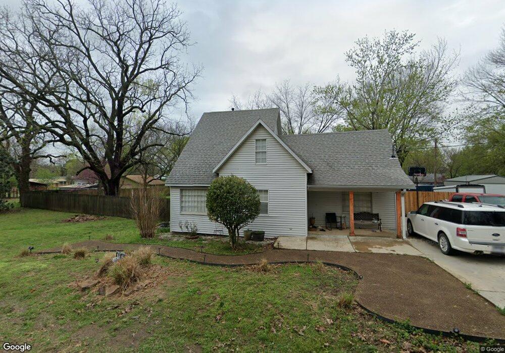
112 S Summit St Prairie Grove, AR 72753
Estimated Value: $238,000 - $278,000
4
Beds
2
Baths
1,600
Sq Ft
$163/Sq Ft
Est. Value
About This Home
This home is located at 112 S Summit St, Prairie Grove, AR 72753 and is currently estimated at $261,101, approximately $163 per square foot. 112 S Summit St is a home located in Washington County with nearby schools including Prairie Grove Elementary School, Prairie Grove Middle School, and Prairie Grove Junior High School.
Ownership History
Date
Name
Owned For
Owner Type
Purchase Details
Closed on
Aug 28, 2008
Sold by
Smith James Stafford and Smith Laurie Jane
Bought by
Phaneuf Jacob
Current Estimated Value
Home Financials for this Owner
Home Financials are based on the most recent Mortgage that was taken out on this home.
Original Mortgage
$79,200
Outstanding Balance
$52,816
Interest Rate
6.66%
Mortgage Type
Purchase Money Mortgage
Estimated Equity
$208,285
Purchase Details
Closed on
Sep 26, 1984
Bought by
Ramsey Harold Dean and Ramsey Mary J
Create a Home Valuation Report for This Property
The Home Valuation Report is an in-depth analysis detailing your home's value as well as a comparison with similar homes in the area
Home Values in the Area
Average Home Value in this Area
Purchase History
| Date | Buyer | Sale Price | Title Company |
|---|---|---|---|
| Phaneuf Jacob | $99,000 | Mercury Title Llc | |
| Ramsey Harold Dean | -- | -- |
Source: Public Records
Mortgage History
| Date | Status | Borrower | Loan Amount |
|---|---|---|---|
| Open | Phaneuf Jacob | $79,200 |
Source: Public Records
Tax History Compared to Growth
Tax History
| Year | Tax Paid | Tax Assessment Tax Assessment Total Assessment is a certain percentage of the fair market value that is determined by local assessors to be the total taxable value of land and additions on the property. | Land | Improvement |
|---|---|---|---|---|
| 2025 | $650 | $38,200 | $11,900 | $26,300 |
| 2024 | $718 | $38,200 | $11,900 | $26,300 |
| 2023 | $787 | $38,200 | $11,900 | $26,300 |
| 2022 | $690 | $24,760 | $5,600 | $19,160 |
| 2021 | $645 | $24,760 | $5,600 | $19,160 |
| 2020 | $597 | $24,760 | $5,600 | $19,160 |
| 2019 | $532 | $16,680 | $5,000 | $11,680 |
| 2018 | $557 | $16,680 | $5,000 | $11,680 |
| 2017 | $549 | $16,680 | $5,000 | $11,680 |
| 2016 | $549 | $16,680 | $5,000 | $11,680 |
| 2015 | $549 | $16,680 | $5,000 | $11,680 |
| 2014 | $589 | $17,430 | $5,000 | $12,430 |
Source: Public Records
Map
Nearby Homes
- 304 S Summit St
- 107 S Ozark St
- 308 S Summit St
- 106 S Ozark St
- TBD Butler St
- 901 E Buchanan St
- 881 E Buchanan St
- 700 Marcella St
- 606 1/2 E Buchanan St
- 711 Marcella St
- 720 Marcella St
- 222 Nebo St
- 252 Nebo St
- 152 Nebo St
- 204 Armstrong St
- 211 Boston St
- 841 Round Top St
- 224 Stapleton Dr
- 212 Marna Lynn Dr
- 4.66 +/- AC Tract 5 Hwy 62 & S Mock St
- 108 N Summit St
- 122 S Summit St
- 109 S Summit St
- 109 S Summit St
- 119 S Ozark St
- 115 S Ozark St
- 104 S Summit St
- 117 S Summit St
- 510 E Cleveland St
- 123 S Summit St
- 511 E Buchanan St
- 100 S Summit St
- 508 E Cleveland St
- 505 E Buchanan St
- 200 S Summit St
- 105 S Summit St
- 507 E Cleveland St
- 101 S Summit St
- 201 S Summit St
- 120 S Ozark St