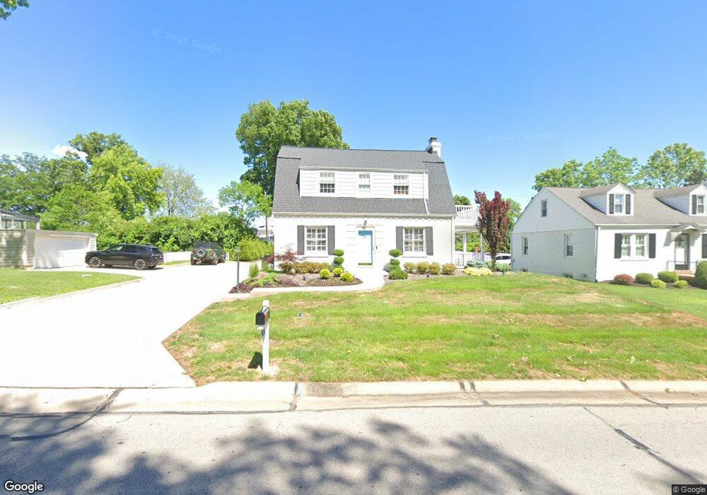
1120 Bopp Rd Saint Louis, MO 63131
Estimated Value: $315,000 - $507,000
2
Beds
2
Baths
1,302
Sq Ft
$298/Sq Ft
Est. Value
About This Home
This home is located at 1120 Bopp Rd, Saint Louis, MO 63131 and is currently estimated at $388,016, approximately $298 per square foot. 1120 Bopp Rd is a home located in St. Louis County with nearby schools including Westchester Elementary School, North Kirkwood Middle School, and Kirkwood Senior High School.
Ownership History
Date
Name
Owned For
Owner Type
Purchase Details
Closed on
Dec 6, 2001
Sold by
Habel Maria D and Habel Andrew J
Bought by
Mcevoy Timothy P and Mcevoy Cheryl J
Current Estimated Value
Home Financials for this Owner
Home Financials are based on the most recent Mortgage that was taken out on this home.
Original Mortgage
$190,000
Outstanding Balance
$75,124
Interest Rate
6.73%
Estimated Equity
$312,892
Purchase Details
Closed on
Dec 21, 2000
Sold by
Habel Maria D and Defabio Maria M
Bought by
Habel Maria D
Home Financials for this Owner
Home Financials are based on the most recent Mortgage that was taken out on this home.
Original Mortgage
$60,000
Interest Rate
7.39%
Purchase Details
Closed on
May 17, 2000
Sold by
Defabio Ronald P & Trustee and Nancy M
Bought by
Defabio Maria M
Purchase Details
Closed on
Sep 15, 1998
Sold by
Davis Gary W and Davis Linda S
Bought by
Defabio Ronald P and Defabio Nancy M
Create a Home Valuation Report for This Property
The Home Valuation Report is an in-depth analysis detailing your home's value as well as a comparison with similar homes in the area
Home Values in the Area
Average Home Value in this Area
Purchase History
| Date | Buyer | Sale Price | Title Company |
|---|---|---|---|
| Mcevoy Timothy P | $200,000 | -- | |
| Habel Maria D | -- | -- | |
| Defabio Maria M | $155,000 | -- | |
| Defabio Ronald P | -- | First American Title |
Source: Public Records
Mortgage History
| Date | Status | Borrower | Loan Amount |
|---|---|---|---|
| Open | Mcevoy Timothy P | $190,000 | |
| Previous Owner | Habel Maria D | $60,000 |
Source: Public Records
Tax History Compared to Growth
Tax History
| Year | Tax Paid | Tax Assessment Tax Assessment Total Assessment is a certain percentage of the fair market value that is determined by local assessors to be the total taxable value of land and additions on the property. | Land | Improvement |
|---|---|---|---|---|
| 2025 | $3,404 | $64,030 | $48,260 | $15,770 |
| 2024 | $3,404 | $58,620 | $36,200 | $22,420 |
| 2023 | $3,351 | $58,620 | $36,200 | $22,420 |
| 2022 | $3,330 | $54,290 | $36,200 | $18,090 |
| 2021 | $3,294 | $54,290 | $36,200 | $18,090 |
| 2020 | $3,210 | $50,850 | $36,200 | $14,650 |
| 2019 | $3,214 | $50,850 | $36,200 | $14,650 |
| 2018 | $2,356 | $33,340 | $22,530 | $10,810 |
| 2017 | $2,362 | $33,340 | $22,530 | $10,810 |
| 2016 | $1,921 | $27,390 | $16,070 | $11,320 |
| 2015 | $1,923 | $27,390 | $16,070 | $11,320 |
| 2014 | $2,750 | $38,440 | $8,380 | $30,060 |
Source: Public Records
Map
Nearby Homes
- 1126 Bopp Rd
- 1090 Kinstern Dr
- 1029 Kinstern Dr
- 11909 Lillian Ave
- 919 Nana Ln
- 11913 Lillian Ave
- 811 Cherry St
- 896 Twin Pine Dr
- 12006 Montour Dr
- 8 Briarbrook Trail
- 1001 Dovergate Dr
- 946 Rochdale Dr
- 918 N Ballas Rd
- 11358 Manchester Rd
- 12224 TBB Roger Ln
- 723 Oak Valley Dr
- 1737 Folkstone Dr
- 1710 Lynkirk Ln
- 535 Kirkshire Dr
- 1003 Ormond Dr