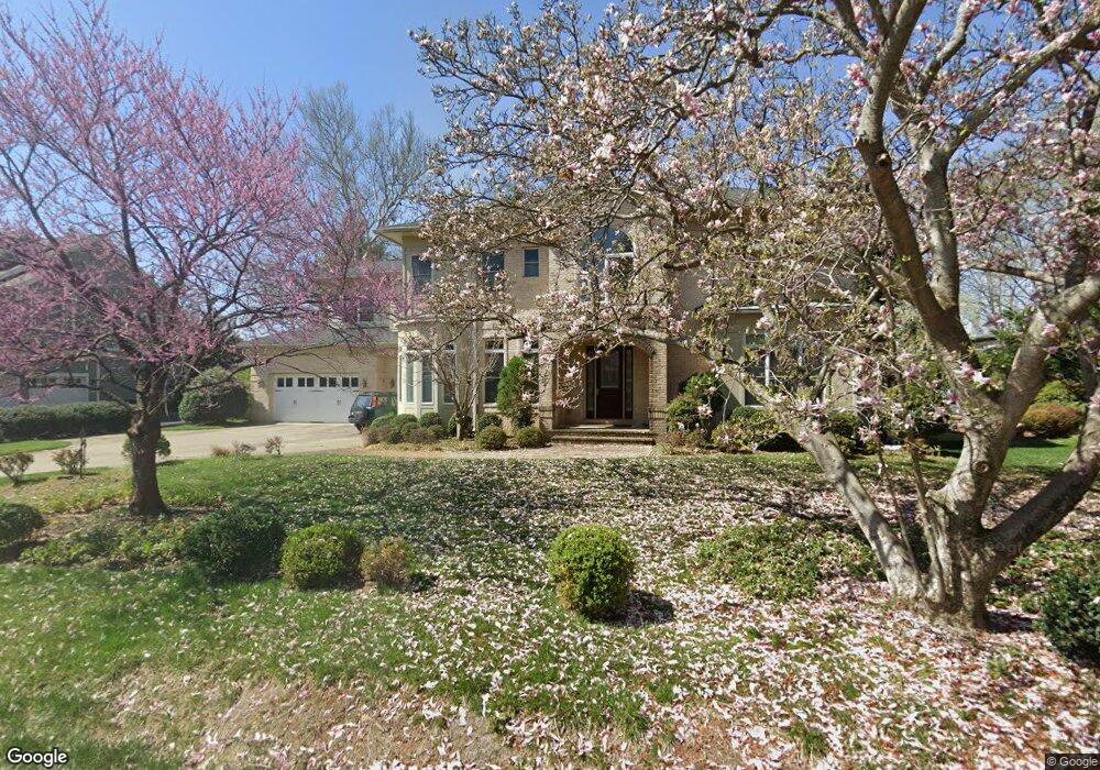
1120 Buchanan St McLean, VA 22101
Estimated Value: $2,517,136 - $2,720,000
6
Beds
6
Baths
--
Sq Ft
14,810
Sq Ft
About This Home
This home is located at 1120 Buchanan St, McLean, VA 22101 and is currently estimated at $2,618,568. 1120 Buchanan St is a home located in Fairfax County with nearby schools including Sherman Elementary School, Cooper Middle School, and Langley High School.
Ownership History
Date
Name
Owned For
Owner Type
Purchase Details
Closed on
May 30, 2008
Sold by
Keystone Llc
Bought by
Tong Shidong and Lei,Siyuan
Current Estimated Value
Home Financials for this Owner
Home Financials are based on the most recent Mortgage that was taken out on this home.
Original Mortgage
$900,000
Outstanding Balance
$573,379
Interest Rate
5.91%
Mortgage Type
New Conventional
Estimated Equity
$2,045,189
Create a Home Valuation Report for This Property
The Home Valuation Report is an in-depth analysis detailing your home's value as well as a comparison with similar homes in the area
Home Values in the Area
Average Home Value in this Area
Purchase History
| Date | Buyer | Sale Price | Title Company |
|---|---|---|---|
| Tong Shidong | $1,560,000 | -- |
Source: Public Records
Mortgage History
| Date | Status | Borrower | Loan Amount |
|---|---|---|---|
| Open | Tong Shidong | $900,000 |
Source: Public Records
Tax History
| Year | Tax Paid | Tax Assessment Tax Assessment Total Assessment is a certain percentage of the fair market value that is determined by local assessors to be the total taxable value of land and additions on the property. | Land | Improvement |
|---|---|---|---|---|
| 2025 | $23,874 | $2,186,080 | $728,000 | $1,458,080 |
| 2024 | $23,874 | $2,020,620 | $618,000 | $1,402,620 |
| 2023 | $22,279 | $1,934,770 | $573,000 | $1,361,770 |
| 2022 | $21,441 | $1,838,090 | $560,000 | $1,278,090 |
| 2021 | $21,412 | $1,789,590 | $544,000 | $1,245,590 |
| 2020 | $21,179 | $1,755,400 | $544,000 | $1,211,400 |
| 2019 | $20,952 | $1,736,560 | $544,000 | $1,192,560 |
| 2018 | $19,515 | $1,696,920 | $523,000 | $1,173,920 |
| 2017 | $19,800 | $1,672,280 | $521,000 | $1,151,280 |
| 2016 | $18,999 | $1,608,000 | $501,000 | $1,107,000 |
| 2015 | $17,762 | $1,559,450 | $486,000 | $1,073,450 |
| 2014 | $17,305 | $1,522,670 | $463,000 | $1,059,670 |
Source: Public Records
Map
Nearby Homes
- 1201 Allendale Rd
- 6601 Madison Mclean Dr
- 6634 Madison Mclean Dr
- 1171 Chain Bridge Rd
- 1146 Wimbledon Dr
- 1008 Jarvis Ct
- 6619 Weatheford Ct
- 1316 Calder Rd
- 1109 Ingleside Ave
- 6871 Churchill Rd
- 6625 Weatheford Ct
- 6800 Fleetwood Rd Unit 705
- 1306 Ballantrae Ct
- 1102 Chain Bridge Rd
- 6634 Brawner St
- 1181 Ballantrae Ln
- 1101 Dead Run Dr
- 6520 Topeka Rd
- 6900 Fleetwood Rd Unit 600
- 6909 Chelsea Rd
- 6617 Melrose Dr
- 1124 Buchanan St
- 1121 Buchanan St
- 6619 Melrose Dr
- 1126 Buchanan St
- 6609 Melrose Dr
- 1127 Buchanan St
- 1125 Buchanan St
- 6616 Melrose Dr
- 6607 Melrose Dr
- 1119 Buchanan St
- 1128 Buchanan St
- 6621 Melrose Dr
- 6618 Melrose Dr
- 6620 Claymore Ct
- 1129 Buchanan St
- 6605 Melrose Dr
- 1131 Buchanan St
- 1125 Ormond Ct
- 6608 Melrose Dr
Your Personal Tour Guide
Ask me questions while you tour the home.