Estimated Value: $263,382 - $276,000
4
Beds
2
Baths
2,129
Sq Ft
$126/Sq Ft
Est. Value
About This Home
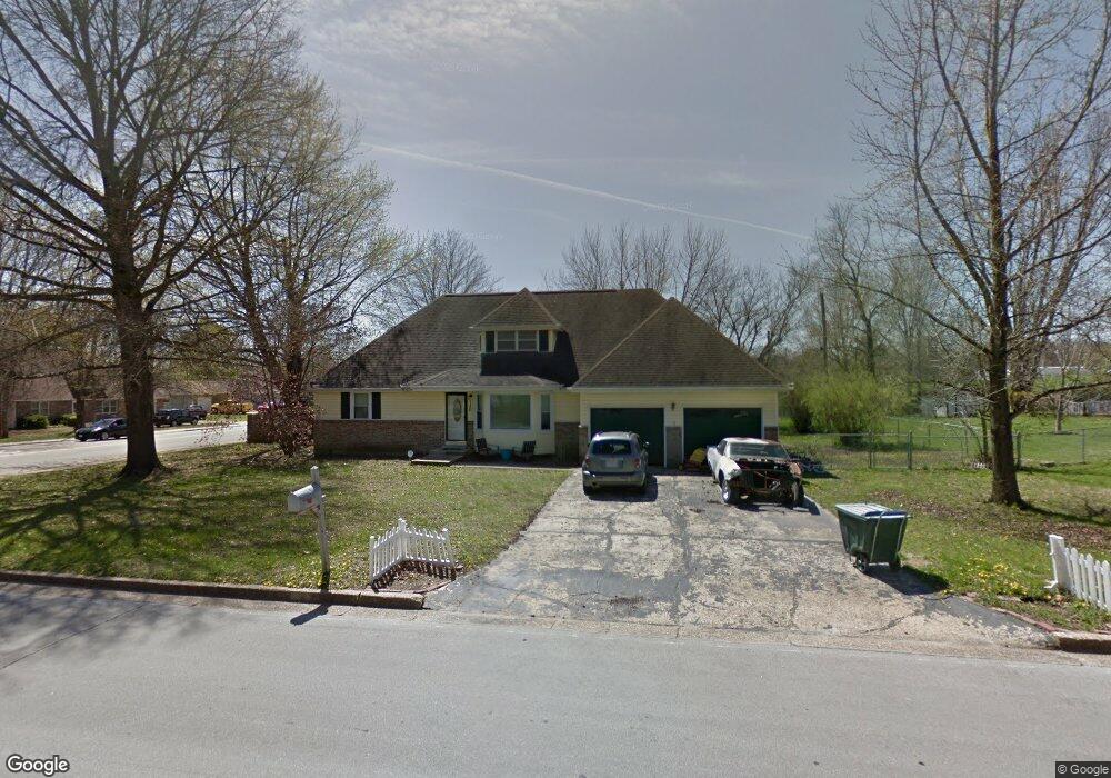
This home is located at 1120 Highland Dr, Rolla, MO 65401 and is currently estimated at $268,461, approximately $126 per square foot. 1120 Highland Dr is a home located in Phelps County with nearby schools including Rolla Junior High School, Rolla Senior High School, and Rolla Seventh-Day Adventist School.
Ownership History
Date
Name
Owned For
Owner Type
Purchase Details
Closed on
Mar 24, 2014
Current Estimated Value
Purchase Details
Closed on
Dec 26, 2007
Purchase Details
Closed on
Mar 28, 2006
Purchase Details
Closed on
Dec 4, 1997
Purchase Details
Closed on
Aug 19, 1997
Purchase Details
Closed on
Aug 12, 1997
Purchase Details
Closed on
Apr 30, 1997
Purchase Details
Closed on
Mar 28, 1997
Purchase Details
Closed on
Apr 16, 1996
Purchase Details
Closed on
Jun 23, 1992
Purchase Details
Closed on
Jan 27, 1992
Purchase Details
Closed on
May 31, 1979
Purchase Details
Closed on
May 25, 1979
Create a Home Valuation Report for This Property
The Home Valuation Report is an in-depth analysis detailing your home's value as well as a comparison with similar homes in the area
Home Values in the Area
Average Home Value in this Area
Purchase History
| Date | Buyer | Sale Price | Title Company |
|---|---|---|---|
| -- | $135,500 | -- | |
| -- | -- | -- | |
| -- | -- | -- | |
| -- | -- | -- | |
| -- | -- | -- | |
| -- | -- | -- | |
| -- | -- | -- | |
| -- | -- | -- | |
| -- | -- | -- | |
| -- | -- | -- | |
| -- | -- | -- | |
| -- | -- | -- | |
| -- | -- | -- |
Source: Public Records
Tax History
| Year | Tax Paid | Tax Assessment Tax Assessment Total Assessment is a certain percentage of the fair market value that is determined by local assessors to be the total taxable value of land and additions on the property. | Land | Improvement |
|---|---|---|---|---|
| 2025 | $1,675 | $32,100 | $5,420 | $26,680 |
| 2024 | $1,500 | $27,910 | $3,250 | $24,660 |
| 2023 | $1,510 | $27,910 | $3,250 | $24,660 |
| 2022 | $1,282 | $27,910 | $3,250 | $24,660 |
| 2021 | $1,291 | $27,910 | $3,250 | $24,660 |
| 2020 | $1,171 | $24,700 | $3,250 | $21,450 |
| 2019 | $1,136 | $24,090 | $3,250 | $20,840 |
| 2018 | $1,126 | $24,090 | $3,250 | $20,840 |
| 2017 | $1,124 | $24,090 | $3,250 | $20,840 |
| 2016 | $1,087 | $24,090 | $3,250 | $20,840 |
| 2015 | -- | $24,090 | $3,250 | $20,840 |
| 2014 | -- | $24,090 | $3,250 | $20,840 |
| 2013 | -- | $24,090 | $0 | $0 |
Source: Public Records
Map
Nearby Homes
- 700 Murry Ln
- 0 McCutchen Unit MIS25079909
- 1506 Whitney Ln
- 1408 Scenic Dr
- 654 Holmes Ln
- 101 Greentree Rd
- 0 Hillview Unit MIS25080072
- 1132 Leonard Ave
- 1306 Broadway St
- 687 Salem Ave
- 502 Fox Creek Rd
- 603 Wakefield Dr
- 1506 Heller St
- 0 Redbud Ln
- 711 E 10th St
- 1500 Independence Rd
- 1603 Independence Rd
- 60 Richard Dr
- 1316 Eastwood Dr
- 1325 Eastwood Dr
- 1118 Highland Dr
- 1200 Highland Dr
- 1117 Highland Dr
- 696 Forum Dr
- 701 Angus Valley Dr
- 694 Forum Dr
- 702 Angus Valley Dr
- 692 Forum Dr
- 1202 Highland Dr
- 607 Whitney Ln
- 1115 Highland Dr
- 1114 Grandsir Ave
- 703 Angus Valley Dr
- 800 Angus Valley Dr
- 1203 Highland Dr
- 605 Whitney Ln
- 690 Forum Dr
- 1112 Grandsir Ave
- 1118 Murry Ln
- 802 Angus Valley Dr
Your Personal Tour Guide
Ask me questions while you tour the home.