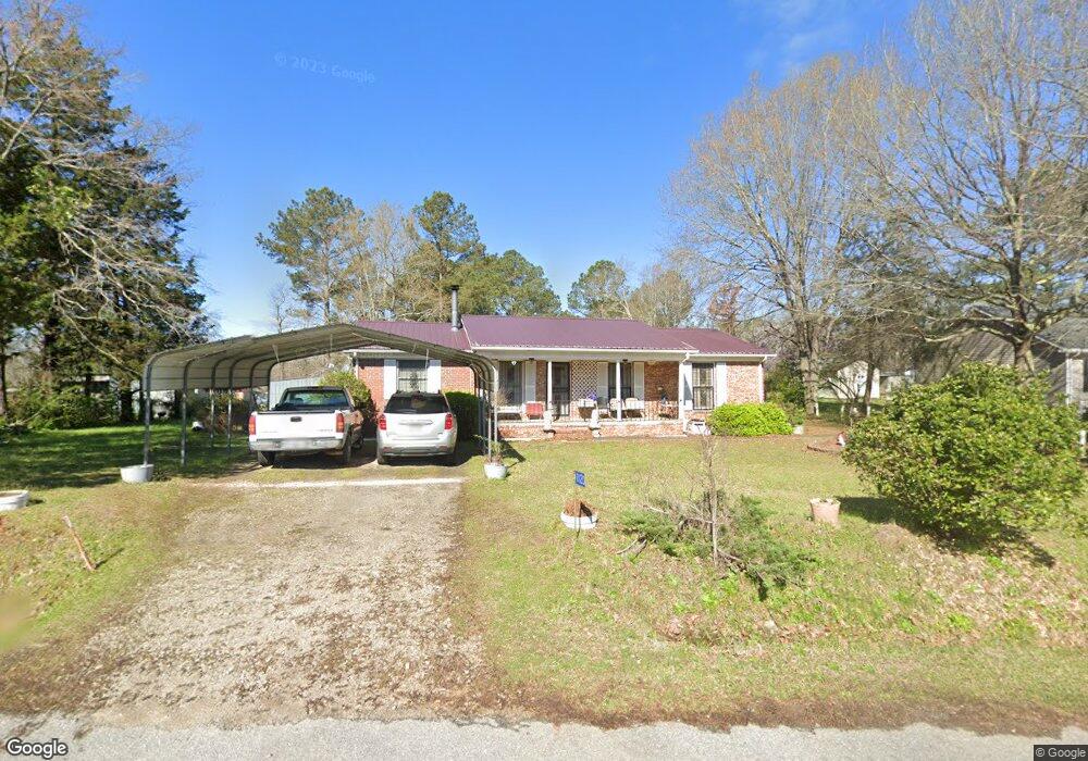
1120 Holly Cir Greensboro, GA 30642
Estimated Value: $220,952 - $350,000
1
Bed
2
Baths
648
Sq Ft
$429/Sq Ft
Est. Value
About This Home
This home is located at 1120 Holly Cir, Greensboro, GA 30642 and is currently estimated at $277,988, approximately $428 per square foot. 1120 Holly Cir is a home located in Greene County with nearby schools including Greene County High School.
Ownership History
Date
Name
Owned For
Owner Type
Purchase Details
Closed on
Dec 9, 2005
Sold by
Reid Noel
Bought by
Franklin Odessa
Current Estimated Value
Purchase Details
Closed on
Jan 1, 1966
Sold by
Franklin Odessa F and Franklin K
Bought by
Franklin Odessa
Purchase Details
Closed on
Jan 1, 1964
Bought by
Slappey Lougenia
Create a Home Valuation Report for This Property
The Home Valuation Report is an in-depth analysis detailing your home's value as well as a comparison with similar homes in the area
Home Values in the Area
Average Home Value in this Area
Purchase History
| Date | Buyer | Sale Price | Title Company |
|---|---|---|---|
| Franklin Odessa | -- | -- | |
| Franklin Odessa | -- | -- | |
| Franklin Odessa F | -- | -- | |
| Slappey Lougenia | -- | -- |
Source: Public Records
Tax History Compared to Growth
Tax History
| Year | Tax Paid | Tax Assessment Tax Assessment Total Assessment is a certain percentage of the fair market value that is determined by local assessors to be the total taxable value of land and additions on the property. | Land | Improvement |
|---|---|---|---|---|
| 2024 | $577 | $85,400 | $5,960 | $79,440 |
| 2023 | $294 | $79,240 | $4,520 | $74,720 |
| 2022 | $534 | $58,240 | $5,200 | $53,040 |
| 2021 | $546 | $51,880 | $5,200 | $46,680 |
| 2020 | $435 | $29,280 | $3,560 | $25,720 |
| 2019 | $441 | $29,280 | $3,560 | $25,720 |
| 2018 | $419 | $29,280 | $3,560 | $25,720 |
| 2017 | $404 | $29,343 | $3,589 | $25,754 |
| 2016 | $425 | $30,395 | $3,589 | $26,806 |
| 2015 | $399 | $30,395 | $3,589 | $26,806 |
| 2014 | $368 | $28,537 | $3,589 | $24,948 |
Source: Public Records
Map
Nearby Homes
- 1131 Planing Mill Rd
- 1141 Planing Mill Rd
- 0 Railroad St Unit 218854
- 0 Railroad St Unit 10578007
- 0 Railroad St Unit 531919
- 1020 Horton Dr
- 1531 E Broad St
- 0 Cunningham Rd
- 2260 Cunningham Rd
- 3021 Penfield Rd
- 0 Union Point Hwy Unit 69532
- 0 Union Point Hwy Unit 7607786
- 0 Union Point Hwy Unit 10555176
- 301 N East St
- 0 Shady Side Ln
- 1060 Twin Pines Cir
- 15 South St Unit Siloam Road
- 0 Maple Cir
- 208 W South St
- 314 W South St
- 1100 Holly Cir
- 2170 Penfield Rd
- 2180 Penfield Rd
- 2241 Penfield Rd
- 1020 Holly Cir
- 2240 Penfield Rd
- 1010 Holly Cir
- 0 Penfield Rd Unit 7468829
- 0 Penfield Rd Unit 7471909
- 0 Penfield Rd Unit 66569
- 0 Penfield Rd Unit 20170187
- 0 Penfield Rd Unit 7596459
- 0 Penfield Rd Unit 9009514
- 0 Penfield Rd Unit 8381643
- 0 Penfield Rd Unit 8460808
- 2251 Penfield Rd
- 2030 Penfield Rd
- 2010 Penfield Rd
- 2280 Penfield Rd
- 1940 Penfield Rd