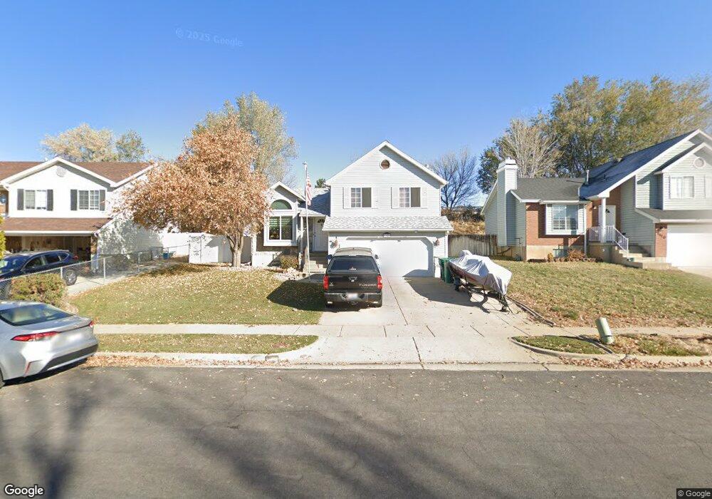
1120 W 2600 N Layton, UT 84041
Estimated Value: $428,811 - $491,000
4
Beds
2
Baths
1,224
Sq Ft
$375/Sq Ft
Est. Value
About This Home
This home is located at 1120 W 2600 N, Layton, UT 84041 and is currently estimated at $458,453, approximately $374 per square foot. 1120 W 2600 N is a home located in Davis County with nearby schools including Lincoln Elementary School, North Layton Junior High School, and Northridge High School.
Ownership History
Date
Name
Owned For
Owner Type
Purchase Details
Closed on
Apr 16, 1998
Sold by
Gundersen Lowell and Gundersen Janae
Bought by
Huncharek Dale and Huncharek Daranee
Current Estimated Value
Home Financials for this Owner
Home Financials are based on the most recent Mortgage that was taken out on this home.
Original Mortgage
$121,350
Outstanding Balance
$23,197
Interest Rate
7.18%
Mortgage Type
VA
Estimated Equity
$435,256
Create a Home Valuation Report for This Property
The Home Valuation Report is an in-depth analysis detailing your home's value as well as a comparison with similar homes in the area
Home Values in the Area
Average Home Value in this Area
Purchase History
| Date | Buyer | Sale Price | Title Company |
|---|---|---|---|
| Huncharek Dale | -- | Avis & Archibald Titel Insur |
Source: Public Records
Mortgage History
| Date | Status | Borrower | Loan Amount |
|---|---|---|---|
| Open | Huncharek Dale | $121,350 |
Source: Public Records
Tax History Compared to Growth
Tax History
| Year | Tax Paid | Tax Assessment Tax Assessment Total Assessment is a certain percentage of the fair market value that is determined by local assessors to be the total taxable value of land and additions on the property. | Land | Improvement |
|---|---|---|---|---|
| 2024 | $1,624 | $205,150 | $99,632 | $105,518 |
| 2023 | $1,604 | $360,000 | $127,651 | $232,349 |
| 2022 | $1,849 | $202,400 | $64,702 | $137,698 |
| 2021 | $1,564 | $268,000 | $83,812 | $184,188 |
| 2020 | $1,366 | $231,000 | $73,386 | $157,614 |
| 2019 | $1,356 | $227,000 | $72,413 | $154,587 |
| 2018 | $1,519 | $204,000 | $72,413 | $131,587 |
| 2016 | $1,314 | $93,940 | $21,250 | $72,690 |
| 2015 | $1,241 | $84,645 | $21,250 | $63,395 |
| 2014 | $1,243 | $87,208 | $21,250 | $65,958 |
| 2013 | -- | $84,561 | $20,680 | $63,881 |
Source: Public Records
Map
Nearby Homes
- 2887 N 1175 W
- 2949 N 1175 W
- 2402 N 725 W
- 850 S 1650 E Unit D
- 2378 N 675 W
- 1548 E 925 S
- 709 W Highway 193
- 781 W 2150 N
- 2875 N Hill Field Rd Unit 58
- 2875 N Hill Field Rd Unit 17
- 2875 N Hill Field Rd Unit 62
- 2211 N 525 W
- 2248 N 500 W
- 2187 N 450 W
- 1606 W 1960 N
- 1208 Valhalla Dr
- 65 Sunset Dr
- 63 Sunset Dr
- 86 Atherton Way
- 1665 W 1960 N