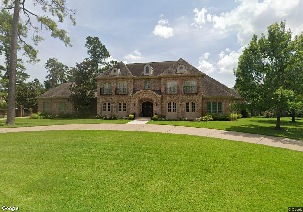
11203 Tynewood Dr Houston, TX 77024
Estimated Value: $3,207,000 - $3,930,939
4
Beds
4
Baths
4,028
Sq Ft
$900/Sq Ft
Est. Value
About This Home
This home is located at 11203 Tynewood Dr, Houston, TX 77024 and is currently estimated at $3,626,980, approximately $900 per square foot. 11203 Tynewood Dr is a home located in Harris County with nearby schools including Memorial Drive Elementary School, Spring Branch Middle School, and Memorial High School.
Ownership History
Date
Name
Owned For
Owner Type
Purchase Details
Closed on
Feb 28, 2025
Sold by
William O Brittain Revocable Trust and Brittain Kandice L
Bought by
Brittain Marital Trust and Brittain
Current Estimated Value
Purchase Details
Closed on
Aug 2, 2012
Sold by
Spolane David A and Spolane Marlene
Bought by
Brittain William O and The William O Brittain Revocable Trust
Purchase Details
Closed on
Dec 15, 1993
Sold by
Moore Charles R
Bought by
Spolane David A
Home Financials for this Owner
Home Financials are based on the most recent Mortgage that was taken out on this home.
Original Mortgage
$265,000
Interest Rate
7.06%
Create a Home Valuation Report for This Property
The Home Valuation Report is an in-depth analysis detailing your home's value as well as a comparison with similar homes in the area
Home Values in the Area
Average Home Value in this Area
Purchase History
| Date | Buyer | Sale Price | Title Company |
|---|---|---|---|
| Brittain Marital Trust | -- | None Listed On Document | |
| Brittain William O | -- | None Available | |
| Spolane David A | -- | -- |
Source: Public Records
Mortgage History
| Date | Status | Borrower | Loan Amount |
|---|---|---|---|
| Previous Owner | Spolane David A | $265,000 |
Source: Public Records
Tax History Compared to Growth
Tax History
| Year | Tax Paid | Tax Assessment Tax Assessment Total Assessment is a certain percentage of the fair market value that is determined by local assessors to be the total taxable value of land and additions on the property. | Land | Improvement |
|---|---|---|---|---|
| 2025 | $20,403 | $3,637,302 | $1,490,400 | $2,146,902 |
| 2024 | $20,403 | $2,628,359 | $1,407,600 | $1,220,759 |
| 2023 | $20,403 | $3,136,935 | $1,345,500 | $1,791,435 |
| 2022 | $55,015 | $2,638,730 | $1,242,000 | $1,396,730 |
| 2021 | $54,534 | $2,510,603 | $1,138,500 | $1,372,103 |
| 2020 | $56,632 | $2,550,684 | $1,138,500 | $1,412,184 |
| 2019 | $57,244 | $2,548,673 | $1,138,500 | $1,410,173 |
| 2018 | $10,420 | $2,250,587 | $1,138,500 | $1,112,087 |
| 2017 | $52,052 | $2,250,587 | $1,138,500 | $1,112,087 |
| 2016 | $50,783 | $2,195,732 | $972,900 | $1,222,832 |
| 2015 | $25,033 | $2,197,881 | $972,900 | $1,224,981 |
| 2014 | $25,033 | $1,955,306 | $931,500 | $1,023,806 |
Source: Public Records
Map
Nearby Homes
- 220 Merrie Way Ln
- 11323 Iris Lee Ln
- 252 Piney Point Rd
- 354 Piney Point Rd
- 247 Piney Point Rd
- 1 Chuckanut Ln
- 11095 Memorial Dr
- 11 River Cir
- 1010 River Bend Dr
- 140 Quail Creek Ct
- 11606 Blalock Ln
- 1006 River Glynn Dr
- 1119 River Glynn Dr
- 11305 Green Vale Dr
- 918 Huntington Cove
- 7 Carlton Park Ct
- 435 Flint Point Dr
- 7914 Woodway Dr
- 4 Glendenning Ln
- 7924 Woodway Dr
- 11207 Tynewood Dr
- 11223 Memorial Dr
- 245 Merrie Way Ln
- 11206 Tynewood Dr
- 11211 Tynewood Dr
- 11302 Memorial Dr
- 11505B Memorial Dr
- 241 Merrie Way Ln
- 11210 Tynewood Dr
- 11130 Wickwood Dr
- 240 Merrie Way Ln
- 11131 Meadowick Dr
- 11131 Wickwood Dr
- 11215 Tynewood Dr
- 11214 Tynewood Dr
- 11315 Memorial Dr
- 237 Merrie Way Ln
- 11207 Tyne Ct
- 11211 Tyne Ct
- 236 Merrie Way Ln