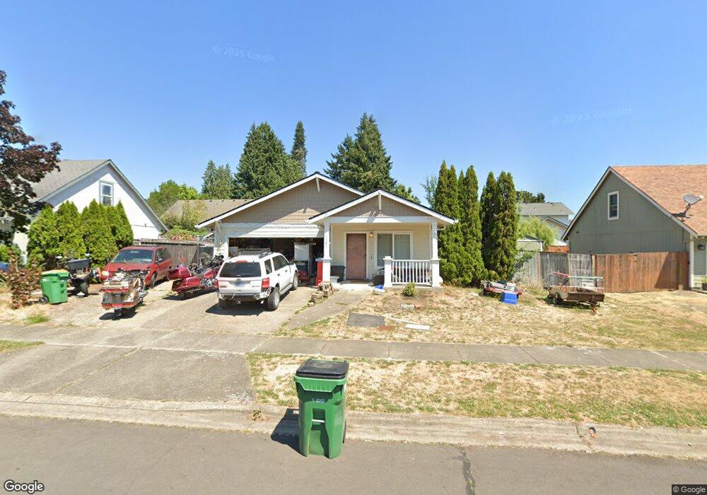
1121 Alyssum Ave Forest Grove, OR 97116
Estimated Value: $443,000 - $512,000
3
Beds
2
Baths
1,191
Sq Ft
$396/Sq Ft
Est. Value
About This Home
This home is located at 1121 Alyssum Ave, Forest Grove, OR 97116 and is currently estimated at $472,231, approximately $396 per square foot. 1121 Alyssum Ave is a home located in Washington County with nearby schools including Harvey Clarke Elementary School, Tom McCall Upper Elementary School, and Neil Armstrong Middle School.
Ownership History
Date
Name
Owned For
Owner Type
Purchase Details
Closed on
Jul 22, 2024
Sold by
Ward Alethia M
Bought by
Ward Alethia M and Allen Ronald W
Current Estimated Value
Purchase Details
Closed on
Apr 10, 1997
Sold by
Skyline Development Inc
Bought by
Ward Alethia M
Home Financials for this Owner
Home Financials are based on the most recent Mortgage that was taken out on this home.
Original Mortgage
$133,436
Interest Rate
7.45%
Mortgage Type
FHA
Create a Home Valuation Report for This Property
The Home Valuation Report is an in-depth analysis detailing your home's value as well as a comparison with similar homes in the area
Home Values in the Area
Average Home Value in this Area
Purchase History
| Date | Buyer | Sale Price | Title Company |
|---|---|---|---|
| Ward Alethia M | -- | None Listed On Document | |
| Ward Alethia M | $135,110 | First American Title Ins Co |
Source: Public Records
Mortgage History
| Date | Status | Borrower | Loan Amount |
|---|---|---|---|
| Previous Owner | Ward Alethia M | $133,436 |
Source: Public Records
Tax History Compared to Growth
Tax History
| Year | Tax Paid | Tax Assessment Tax Assessment Total Assessment is a certain percentage of the fair market value that is determined by local assessors to be the total taxable value of land and additions on the property. | Land | Improvement |
|---|---|---|---|---|
| 2026 | $4,498 | $252,570 | -- | -- |
| 2025 | $4,498 | $245,220 | -- | -- |
| 2024 | $4,339 | $238,080 | -- | -- |
| 2023 | $4,339 | $231,150 | $0 | $0 |
| 2022 | $3,794 | $231,150 | $0 | $0 |
| 2021 | $3,745 | $217,890 | $0 | $0 |
| 2020 | $3,725 | $211,550 | $0 | $0 |
| 2019 | $3,642 | $205,390 | $0 | $0 |
| 2018 | $3,530 | $199,410 | $0 | $0 |
| 2017 | $3,421 | $193,610 | $0 | $0 |
| 2016 | $3,325 | $187,980 | $0 | $0 |
| 2015 | $3,197 | $182,510 | $0 | $0 |
| 2014 | $3,182 | $177,200 | $0 | $0 |
Source: Public Records
Map
Nearby Homes
- 1224 Alyssum Ave
- 922 Rosebud Ct
- 1425 Willamina Ave
- 918 Rosebud Ct
- 911 Rosebud Ct
- 920 Rosebud Ct
- 924 Rosebud Ct
- 1104 Magnolia Way
- 507-FH Plan at Parkview Terrace
- 504-STD Plan at Parkview Terrace
- Poppy - Plan 308C at Parkview Terrace
- 430A Plan at Parkview Terrace
- Plan 400 at Parkview Terrace
- 506-FH Plan at Parkview Terrace
- Plan 325 at Parkview Terrace
- 505-STD Plan at Parkview Terrace
- 508-MFH Plan at Parkview Terrace
- 3245 Butte Dr
- 504-FH Plan at Parkview Terrace
- 506-STD Plan at Parkview Terrace
- 1119 Alyssum Ave
- 1125 Alyssum Ave
- 1122 Nichols Ln
- 1120 Nichols Ln
- 3206 Periwinkle St
- 1120 Alyssum Ave
- 1117 Alyssum Ave
- 3122 Periwinkle St
- 1118 Nichols Ln
- 3149 Periwinkle St
- 1112 Alyssum Ave
- 1115 Alyssum Ave
- 1116 Nichols Ln
- 3205 Periwinkle St
- 3119 Twinflower St
- 3116 Periwinkle St
- 3119 Periwinkle St
- 3113 Twinflower St
- 1153 Nichols Ln
- 1155 Nichols Ln