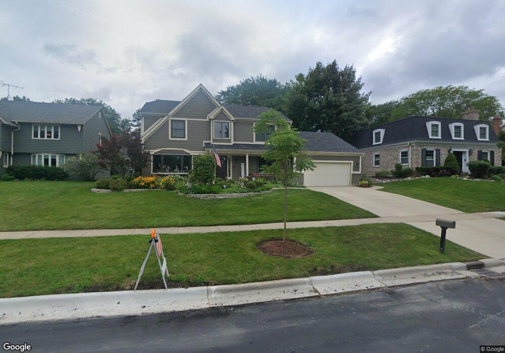
1121 Avalon Ln Libertyville, IL 60048
Estimated Value: $762,000 - $997,000
--
Bed
3
Baths
3,033
Sq Ft
$287/Sq Ft
Est. Value
About This Home
This home is located at 1121 Avalon Ln, Libertyville, IL 60048 and is currently estimated at $869,464, approximately $286 per square foot. 1121 Avalon Ln is a home located in Lake County with nearby schools including Adler Park School, Highland Middle School, and Libertyville High School.
Ownership History
Date
Name
Owned For
Owner Type
Purchase Details
Closed on
Jun 18, 1998
Sold by
Haas Robert J and Haas Mary C
Bought by
Ryan Timothy J and Ryan Kathleen
Current Estimated Value
Home Financials for this Owner
Home Financials are based on the most recent Mortgage that was taken out on this home.
Original Mortgage
$216,000
Outstanding Balance
$43,852
Interest Rate
7.22%
Estimated Equity
$825,612
Purchase Details
Closed on
May 3, 1996
Sold by
Shah Satish Kantilal and Satish Kantilal Shah Living Tr
Bought by
Haas Robert J and Haas Mary C
Home Financials for this Owner
Home Financials are based on the most recent Mortgage that was taken out on this home.
Original Mortgage
$175,000
Interest Rate
7.78%
Purchase Details
Closed on
Dec 6, 1994
Sold by
Shah Satish K and Shah Satish Kantilal
Bought by
Shah Satish Kantilal
Create a Home Valuation Report for This Property
The Home Valuation Report is an in-depth analysis detailing your home's value as well as a comparison with similar homes in the area
Home Values in the Area
Average Home Value in this Area
Purchase History
| Date | Buyer | Sale Price | Title Company |
|---|---|---|---|
| Ryan Timothy J | $312,500 | Chicago Title Insurance Co | |
| Haas Robert J | $280,000 | -- | |
| Shah Satish Kantilal | -- | -- |
Source: Public Records
Mortgage History
| Date | Status | Borrower | Loan Amount |
|---|---|---|---|
| Open | Ryan Timothy J | $216,000 | |
| Previous Owner | Haas Robert J | $175,000 |
Source: Public Records
Tax History Compared to Growth
Tax History
| Year | Tax Paid | Tax Assessment Tax Assessment Total Assessment is a certain percentage of the fair market value that is determined by local assessors to be the total taxable value of land and additions on the property. | Land | Improvement |
|---|---|---|---|---|
| 2024 | $16,289 | $227,967 | $62,088 | $165,879 |
| 2023 | $14,852 | $210,263 | $57,266 | $152,997 |
| 2022 | $14,852 | $191,702 | $55,042 | $136,660 |
| 2021 | $14,300 | $187,575 | $53,857 | $133,718 |
| 2020 | $15,344 | $204,913 | $58,835 | $146,078 |
| 2019 | $14,963 | $202,965 | $58,276 | $144,689 |
| 2018 | $14,058 | $197,367 | $68,464 | $128,903 |
| 2017 | $13,864 | $191,136 | $66,303 | $124,833 |
| 2016 | $13,410 | $181,223 | $62,864 | $118,359 |
| 2015 | $13,295 | $169,383 | $58,757 | $110,626 |
| 2014 | $11,694 | $154,094 | $55,208 | $98,886 |
| 2012 | $10,798 | $148,044 | $55,688 | $92,356 |
Source: Public Records
Map
Nearby Homes
- 1211 Parliament Ct
- 922 N Milwaukee Ave Unit A
- 204 W Ellis Ave
- 208 W Ellis Ave
- 212 W Ellis Ave
- 31132-31140 N Milwaukee Ave
- 224 Newberry Ave
- 616 Parkside Ct
- 619 Parkside Ct
- 662 Parkside Ct
- 694 Parkside Ct
- 217 E Church St
- 16108 W Des Plaines Dr
- 505 Lange Ct
- 16051 W Des Plaines Dr
- 420 W Cook Ave
- 212 Elm Ct
- 601 Broadway St
- 121 4th St
- 112 3rd St
- 1117 Avalon Ln
- 1127 Avalon Ln
- 1212 Parliament Ct
- 1210 Parliament Ct
- 1214 Parliament Ct
- 1111 Avalon Ln
- 1201 Avalon Ln
- 311 Hyatt Dr
- 1208 Parliament Ct
- 1116 Avalon Ln
- 1216 Parliament Ct
- 1105 Avalon Ln
- 1209 Avalon Ln
- 310 Hyatt Dr
- 1110 Avalon Ln
- 1206 Parliament Ct
- 319 Hyatt Dr
- 1213 Parliament Ct
- 1215 Parliament Ct
- 1210 Avalon Ln