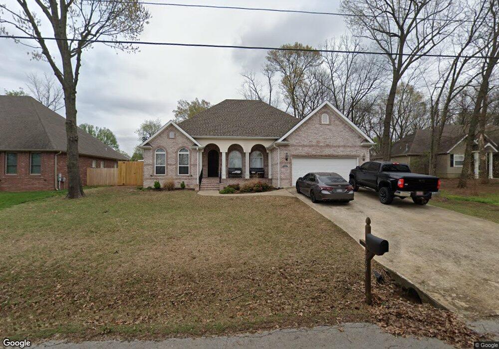
1121 Ditmars Rd Prairie Grove, AR 72753
Estimated Value: $421,000 - $449,000
3
Beds
3
Baths
2,661
Sq Ft
$163/Sq Ft
Est. Value
About This Home
This home is located at 1121 Ditmars Rd, Prairie Grove, AR 72753 and is currently estimated at $434,485, approximately $163 per square foot. 1121 Ditmars Rd is a home located in Washington County with nearby schools including Prairie Grove Elementary School, Prairie Grove Middle School, and Prairie Grove Junior High School.
Ownership History
Date
Name
Owned For
Owner Type
Purchase Details
Closed on
Jun 18, 2008
Sold by
Countrywide Home Loans Inc
Bought by
Raper Ronald and Raper Sonya
Current Estimated Value
Home Financials for this Owner
Home Financials are based on the most recent Mortgage that was taken out on this home.
Original Mortgage
$186,966
Outstanding Balance
$119,453
Interest Rate
6.05%
Mortgage Type
FHA
Estimated Equity
$315,032
Create a Home Valuation Report for This Property
The Home Valuation Report is an in-depth analysis detailing your home's value as well as a comparison with similar homes in the area
Home Values in the Area
Average Home Value in this Area
Purchase History
| Date | Buyer | Sale Price | Title Company |
|---|---|---|---|
| Raper Ronald | $190,000 | Associates Closing & Title |
Source: Public Records
Mortgage History
| Date | Status | Borrower | Loan Amount |
|---|---|---|---|
| Open | Raper Ronald | $186,966 |
Source: Public Records
Tax History Compared to Growth
Tax History
| Year | Tax Paid | Tax Assessment Tax Assessment Total Assessment is a certain percentage of the fair market value that is determined by local assessors to be the total taxable value of land and additions on the property. | Land | Improvement |
|---|---|---|---|---|
| 2025 | $2,091 | $76,060 | $8,000 | $68,060 |
| 2024 | $2,114 | $76,060 | $8,000 | $68,060 |
| 2023 | $2,166 | $76,060 | $8,000 | $68,060 |
| 2022 | $2,092 | $49,160 | $6,000 | $43,160 |
| 2021 | $1,879 | $47,220 | $6,000 | $41,220 |
| 2020 | $1,769 | $47,220 | $6,000 | $41,220 |
| 2019 | $1,689 | $37,950 | $4,000 | $33,950 |
| 2018 | $1,714 | $37,950 | $4,000 | $33,950 |
| 2017 | $1,696 | $37,950 | $4,000 | $33,950 |
| 2016 | $1,696 | $37,950 | $4,000 | $33,950 |
| 2015 | $1,696 | $37,950 | $4,000 | $33,950 |
| 2014 | $1,841 | $40,640 | $4,000 | $36,640 |
Source: Public Records
Map
Nearby Homes
- 812 Cedar Ln
- 261 Hearthstone Cir
- 807 Maple St
- 971 Pebble Dr
- 461 Maya St
- 1042 Vista Ave
- 441 Maya St
- 442 Maya St
- 581 Crystal Dr
- DENTON Plan at Hudson Heights
- GARLAND Plan at Hudson Heights
- EUREKA Plan at Hudson Heights
- DEAN Plan at Hudson Heights
- KINGSTON Plan at Hudson Heights
- 1021 Vista Ave
- 422 Maya St
- 402 Maya St
- 16453 Stonewall Rd
- 1498 Viney Grove Rd
- 505 Shady Acres Ln
- 1131 Ditmars Rd
- 241 Hearthstone Cir
- 1111 Ditmars Rd
- 1141 Ditmars Rd
- 231 Hearthstone Cir
- 1151 Ditmars Rd
- 1101 Ditmars Rd
- 221 Hearthstone Cir
- 271 Hearthstone Cir
- 1161 Ditmars Rd
- 200 Hearthstone Cir
- 211 Hearthstone Cir
- 280 Hearthstone Cir
- 808 Spruce St
- 201 Hearthstone Cir
- 810 Spruce St
- 891 Crawford (Lot 38) Ln
- 891 Crawford Ln
- 190 Hearthstone Cir
- 881 Crawford Ln