Estimated Value: $312,000 - $317,000
3
Beds
2
Baths
1,791
Sq Ft
$176/Sq Ft
Est. Value
About This Home
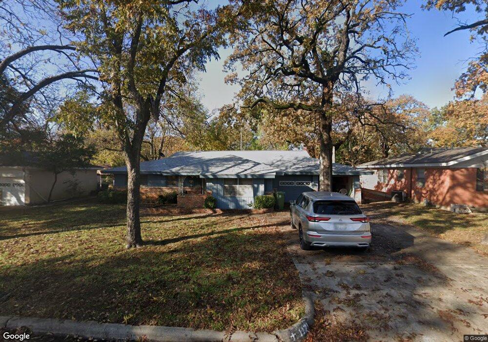
This home is located at 1121 Mason Dr, Hurst, TX 76053 and is currently estimated at $314,321, approximately $175 per square foot. 1121 Mason Dr is a home located in Tarrant County with nearby schools including Harrison Lane Elementary School, Hurst J High School, and L.D. Bell High School.
Ownership History
Date
Name
Owned For
Owner Type
Purchase Details
Closed on
Nov 15, 2010
Sold by
Tillinghast Johny F and Tillinghast Donna K
Bought by
Tillinghast Johny F and Tillinghast Donna K
Current Estimated Value
Home Financials for this Owner
Home Financials are based on the most recent Mortgage that was taken out on this home.
Original Mortgage
$178,500
Outstanding Balance
$117,230
Interest Rate
4.18%
Mortgage Type
Reverse Mortgage Home Equity Conversion Mortgage
Estimated Equity
$197,091
Purchase Details
Closed on
May 17, 2001
Sold by
Tillinghast Johnny F
Bought by
Tillinghast Johnny F and Tillinghast Donna K
Purchase Details
Closed on
Sep 24, 1997
Sold by
Tillinghast Que T
Bought by
Tillinghast Que T and Quet T Tillinghast Trust
Create a Home Valuation Report for This Property
The Home Valuation Report is an in-depth analysis detailing your home's value as well as a comparison with similar homes in the area
Home Values in the Area
Average Home Value in this Area
Purchase History
| Date | Buyer | Sale Price | Title Company |
|---|---|---|---|
| Tillinghast Johny F | -- | Sendera Title | |
| Tillinghast Johnny F | -- | -- | |
| Tillinghast Que T | -- | -- |
Source: Public Records
Mortgage History
| Date | Status | Borrower | Loan Amount |
|---|---|---|---|
| Open | Tillinghast Johny F | $178,500 |
Source: Public Records
Tax History Compared to Growth
Tax History
| Year | Tax Paid | Tax Assessment Tax Assessment Total Assessment is a certain percentage of the fair market value that is determined by local assessors to be the total taxable value of land and additions on the property. | Land | Improvement |
|---|---|---|---|---|
| 2025 | $788 | $320,623 | $55,000 | $265,623 |
| 2024 | $788 | $320,623 | $55,000 | $265,623 |
| 2023 | $813 | $307,995 | $40,000 | $267,995 |
| 2022 | $4,590 | $270,203 | $40,000 | $230,203 |
| 2021 | $4,371 | $226,907 | $40,000 | $186,907 |
| 2020 | $3,964 | $203,059 | $40,000 | $163,059 |
| 2019 | $3,666 | $195,368 | $40,000 | $155,368 |
| 2018 | $1,454 | $136,161 | $19,000 | $117,161 |
| 2017 | $3,132 | $177,732 | $19,000 | $158,732 |
| 2016 | $2,848 | $169,118 | $19,000 | $150,118 |
| 2015 | $1,466 | $102,300 | $15,000 | $87,300 |
| 2014 | $1,466 | $102,300 | $15,000 | $87,300 |
Source: Public Records
Map
Nearby Homes
- 1136 Simpson Dr
- 1016 Keith Dr
- 420 Bedford Ct W
- 409 Vicki Place
- 400 Joanna Dr
- 1220 Norwood Dr
- 1208 Karla Dr
- 905 Brown Trail
- 127 W Cedar St
- 1337 Harrison Ln
- 802 Brown Trail
- 1208 Birch St
- 803 Glenda Dr
- 116 Oakhurst Dr
- 624 Harrison Ln
- 1352 Simpson Dr
- 1348 Norwood Dr
- 341 Hurst Dr
- 344 Bedford Ct E
- 231 Elm St