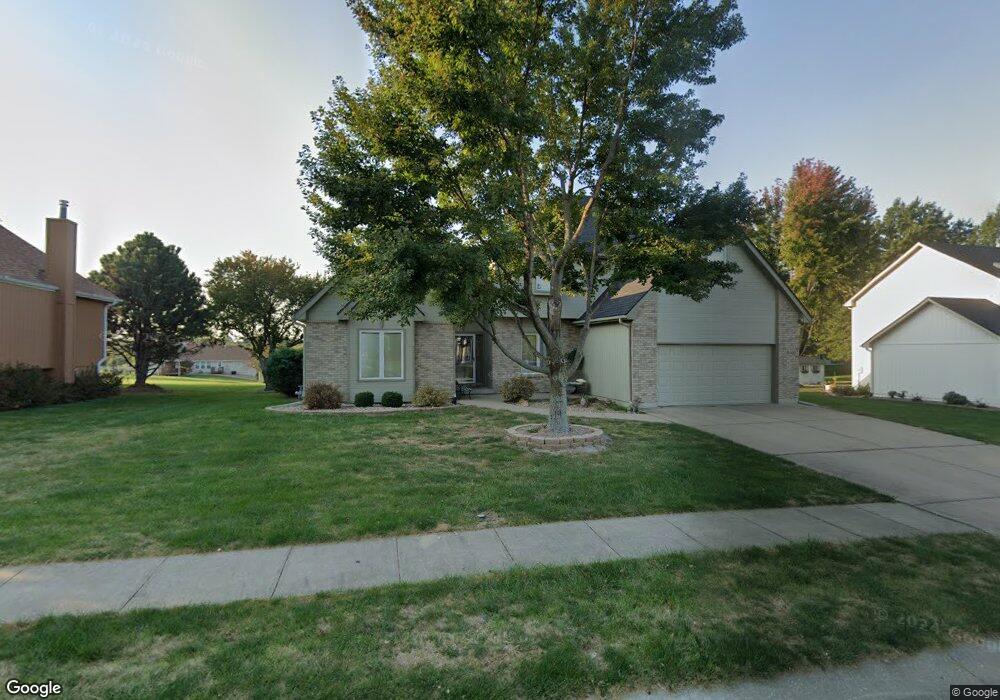
1121 SW Foxtail Dr Grain Valley, MO 64029
Estimated Value: $359,000 - $433,000
3
Beds
5
Baths
2,510
Sq Ft
$158/Sq Ft
Est. Value
About This Home
This home is located at 1121 SW Foxtail Dr, Grain Valley, MO 64029 and is currently estimated at $396,959, approximately $158 per square foot. 1121 SW Foxtail Dr is a home located in Jackson County with nearby schools including Grain Valley High School.
Ownership History
Date
Name
Owned For
Owner Type
Purchase Details
Closed on
Jan 28, 1997
Sold by
Peterson Richard A and Peterson Beverly J
Bought by
Griffin Vernon P and Griffin Sherri L
Current Estimated Value
Home Financials for this Owner
Home Financials are based on the most recent Mortgage that was taken out on this home.
Original Mortgage
$140,000
Interest Rate
7.64%
Mortgage Type
Balloon
Purchase Details
Closed on
Aug 7, 1996
Sold by
R P M Enterprises Inc
Bought by
Peterson Richard A and Peterson Beverly J
Home Financials for this Owner
Home Financials are based on the most recent Mortgage that was taken out on this home.
Original Mortgage
$140,000
Interest Rate
8.32%
Mortgage Type
Construction
Create a Home Valuation Report for This Property
The Home Valuation Report is an in-depth analysis detailing your home's value as well as a comparison with similar homes in the area
Home Values in the Area
Average Home Value in this Area
Purchase History
| Date | Buyer | Sale Price | Title Company |
|---|---|---|---|
| Griffin Vernon P | -- | Stewart Title | |
| Peterson Richard A | -- | -- |
Source: Public Records
Mortgage History
| Date | Status | Borrower | Loan Amount |
|---|---|---|---|
| Closed | Griffin Vernon P | $140,000 | |
| Previous Owner | Peterson Richard A | $140,000 |
Source: Public Records
Tax History
| Year | Tax Paid | Tax Assessment Tax Assessment Total Assessment is a certain percentage of the fair market value that is determined by local assessors to be the total taxable value of land and additions on the property. | Land | Improvement |
|---|---|---|---|---|
| 2025 | $4,063 | $56,725 | $8,326 | $48,399 |
| 2024 | $3,911 | $49,326 | $6,034 | $43,292 |
| 2023 | $3,911 | $49,326 | $4,558 | $44,768 |
| 2022 | $4,926 | $54,340 | $5,937 | $48,403 |
| 2021 | $4,811 | $54,340 | $5,937 | $48,403 |
| 2020 | $4,650 | $51,805 | $5,937 | $45,868 |
| 2019 | $4,555 | $51,805 | $5,937 | $45,868 |
| 2018 | $4,243 | $45,087 | $5,167 | $39,920 |
| 2016 | $3,738 | $39,748 | $3,607 | $36,141 |
Source: Public Records
Map
Nearby Homes
- 1011 SW Foxtail Dr
- 913 SW Abar Dr
- 801 SW Shorthorn Dr
- 632 SW Lakeview Dr
- 826 SW Ryan Rd
- 6825 S Arnett Rd
- TBD E Stony Point School Rd
- 501 SW Whitestone Dr
- 545 S Minter Rd
- 1506 SW Cross Creek Dr
- 521 S Minter Rd
- 600 SW Valley Dr
- 29800 E 65th St
- 647 SW Crestview Dr
- 7211 S Arnett Rd
- 309 S Minter Rd
- 518 SW Valley Dr
- 10510 S Cedar Ridge Trail
- 6205 Chiles Rd
- 817 Stone Brook Dr
- 1125 SW Foxtail Dr
- 1117 SW Foxtail Dr
- 1118 SW Foxtail Dr
- 1201 SW Foxtail Dr
- 1113 SW Foxtail Dr
- 1112 SW Foxtail Dr
- 1124 SW Foxtail Dr
- 1205 SW Foxtail Dr
- 1109 SW Foxtail Dr
- 1118 W Ryan Rd
- 1200 W Ryan Rd
- 1112 W Ryan Rd
- 1209 SW Foxtail Dr
- 1204 SW Foxtail Dr
- 1106 SW Foxtail Dr
- 1105 SW Foxtail Dr
- 1019 SW Montana Ridge Dr
- 1017 SW Montana Ridge Dr
- 1020 SW Montana Ridge Dr
- 1106 W Ryan Rd
Your Personal Tour Guide
Ask me questions while you tour the home.