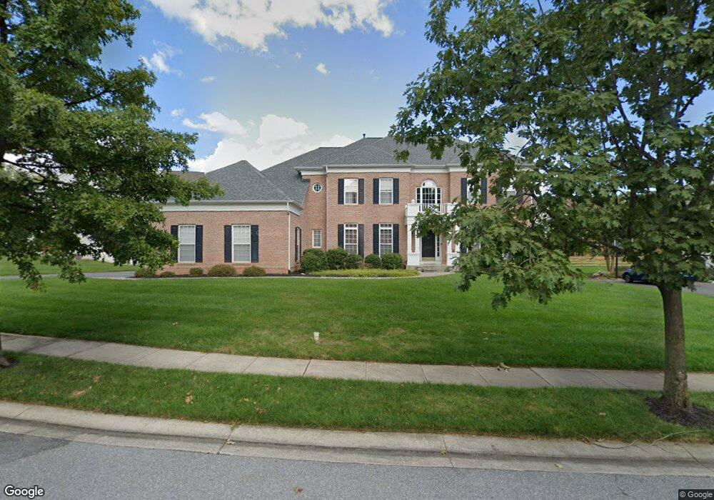
11217 Appaloosa Dr Reisterstown, MD 21136
Estimated Value: $775,000 - $880,000
--
Bed
4
Baths
3,970
Sq Ft
$206/Sq Ft
Est. Value
About This Home
This home is located at 11217 Appaloosa Dr, Reisterstown, MD 21136 and is currently estimated at $817,851, approximately $206 per square foot. 11217 Appaloosa Dr is a home located in Baltimore County with nearby schools including Glyndon Elementary School, Franklin Middle, and Franklin High.
Ownership History
Date
Name
Owned For
Owner Type
Purchase Details
Closed on
Jun 26, 2006
Sold by
Shaw David L
Bought by
Shevrin Andrew G and Shevrin Ellen B
Current Estimated Value
Home Financials for this Owner
Home Financials are based on the most recent Mortgage that was taken out on this home.
Original Mortgage
$249,000
Outstanding Balance
$199,150
Interest Rate
6.6%
Mortgage Type
Purchase Money Mortgage
Estimated Equity
$618,701
Purchase Details
Closed on
Jun 22, 2006
Sold by
Shaw David L
Bought by
Shevrin Andrew G and Shevrin Ellen B
Home Financials for this Owner
Home Financials are based on the most recent Mortgage that was taken out on this home.
Original Mortgage
$249,000
Outstanding Balance
$199,150
Interest Rate
6.6%
Mortgage Type
Purchase Money Mortgage
Estimated Equity
$618,701
Purchase Details
Closed on
Apr 5, 2002
Sold by
Pulte Home Corporation
Bought by
Shaw David L and Shaw Kori Bevans
Create a Home Valuation Report for This Property
The Home Valuation Report is an in-depth analysis detailing your home's value as well as a comparison with similar homes in the area
Home Values in the Area
Average Home Value in this Area
Purchase History
| Date | Buyer | Sale Price | Title Company |
|---|---|---|---|
| Shevrin Andrew G | $740,000 | -- | |
| Shevrin Andrew G | $740,000 | -- | |
| Shaw David L | $465,000 | -- |
Source: Public Records
Mortgage History
| Date | Status | Borrower | Loan Amount |
|---|---|---|---|
| Open | Shevrin Andrew G | $249,000 | |
| Open | Shevrin Andrew G | $417,000 | |
| Closed | Shevrin Andrew G | $249,000 | |
| Closed | Shevrin Andrew G | $417,000 |
Source: Public Records
Tax History Compared to Growth
Tax History
| Year | Tax Paid | Tax Assessment Tax Assessment Total Assessment is a certain percentage of the fair market value that is determined by local assessors to be the total taxable value of land and additions on the property. | Land | Improvement |
|---|---|---|---|---|
| 2025 | $8,555 | $630,567 | -- | -- |
| 2024 | $8,555 | $571,300 | $162,100 | $409,200 |
| 2023 | $4,058 | $564,633 | $0 | $0 |
| 2022 | $8,124 | $557,967 | $0 | $0 |
| 2021 | $8,018 | $551,300 | $162,100 | $389,200 |
| 2020 | $8,018 | $551,300 | $162,100 | $389,200 |
| 2019 | $7,788 | $551,300 | $162,100 | $389,200 |
| 2018 | $8,293 | $582,100 | $162,100 | $420,000 |
| 2017 | $7,875 | $563,133 | $0 | $0 |
| 2016 | $7,879 | $544,167 | $0 | $0 |
| 2015 | $7,879 | $525,200 | $0 | $0 |
| 2014 | $7,879 | $525,200 | $0 | $0 |
Source: Public Records
Map
Nearby Homes
- 648 Glynock Place
- 12314 Bonfire Dr
- 12406 Old Grey Mare Ct
- 10 Greensborough Rd
- 7 Putman Ct
- 12 Greensborough Rd
- 1 Brampton Ct
- 10944 Baskerville Rd
- 49 Merino Ct
- 611 Brickston Rd
- 10 Simpson Ct
- 570 Kennington Rd
- 13 Bellinger Ct
- 4 Romney Ct
- 10 Wensley Dale Ct
- 14 Golden Grass Ct
- 15 Gloucester Ct
- 12 Timber Run Ct
- 3813 Tabor Rd
- 341 Central Ave
- 11215 Appaloosa Dr
- 11219 Appaloosa Dr
- 12302 High Stakes Dr
- 12300 High Stakes Dr
- 12304 High Stakes Dr
- 11220 Appaloosa Dr
- 11221 Appaloosa Dr
- 11222 Appaloosa Dr
- 11218 Appaloosa Dr
- 12306 High Stakes Dr
- 11214 Appaloosa Dr
- 11212 Appaloosa Dr
- 11224 Appaloosa Dr
- 11210 Appaloosa Dr
- 11216 Appaloosa Dr
- 11223 Appaloosa Dr
- 12303 High Stakes Dr
- 12209 Appaloosa Dr
- 12305 High Stakes Dr
- 12308 High Stakes Dr