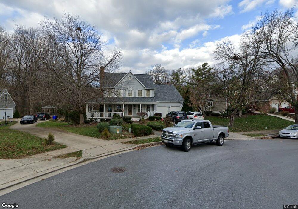
11234 Peartree Way Columbia, MD 21044
Hickory Ridge NeighborhoodEstimated Value: $711,000 - $780,000
--
Bed
3
Baths
2,616
Sq Ft
$287/Sq Ft
Est. Value
About This Home
This home is located at 11234 Peartree Way, Columbia, MD 21044 and is currently estimated at $750,483, approximately $286 per square foot. 11234 Peartree Way is a home located in Howard County with nearby schools including Swansfield Elementary School, Harpers Choice Middle School, and Wilde Lake High.
Ownership History
Date
Name
Owned For
Owner Type
Purchase Details
Closed on
Dec 15, 2000
Sold by
Chesnutt Gregory W
Bought by
Gunderson Gabriel M and Gunderson Robin A
Current Estimated Value
Purchase Details
Closed on
Jun 4, 1998
Sold by
Nationwide Mutual Insurance Co
Bought by
Chesnutt Gregory W
Purchase Details
Closed on
Dec 2, 1997
Sold by
Choe Mok
Bought by
Nationwide Mutual Insurance Co and A Ohio Corporation
Create a Home Valuation Report for This Property
The Home Valuation Report is an in-depth analysis detailing your home's value as well as a comparison with similar homes in the area
Home Values in the Area
Average Home Value in this Area
Purchase History
| Date | Buyer | Sale Price | Title Company |
|---|---|---|---|
| Gunderson Gabriel M | $310,000 | -- | |
| Chesnutt Gregory W | $260,000 | -- | |
| Nationwide Mutual Insurance Co | $270,000 | -- |
Source: Public Records
Mortgage History
| Date | Status | Borrower | Loan Amount |
|---|---|---|---|
| Closed | Chesnutt Gregory W | -- |
Source: Public Records
Tax History Compared to Growth
Tax History
| Year | Tax Paid | Tax Assessment Tax Assessment Total Assessment is a certain percentage of the fair market value that is determined by local assessors to be the total taxable value of land and additions on the property. | Land | Improvement |
|---|---|---|---|---|
| 2025 | $9,270 | $653,267 | $0 | $0 |
| 2024 | $9,270 | $632,100 | $260,300 | $371,800 |
| 2023 | $8,750 | $598,033 | $0 | $0 |
| 2022 | $8,302 | $563,967 | $0 | $0 |
| 2021 | $7,550 | $529,900 | $225,600 | $304,300 |
| 2020 | $7,550 | $504,133 | $0 | $0 |
| 2019 | $7,205 | $478,367 | $0 | $0 |
| 2018 | $6,525 | $452,600 | $169,300 | $283,300 |
| 2017 | $6,432 | $452,600 | $0 | $0 |
| 2016 | $1,475 | $442,467 | $0 | $0 |
| 2015 | $1,475 | $437,400 | $0 | $0 |
| 2014 | $1,439 | $437,167 | $0 | $0 |
Source: Public Records
Map
Nearby Homes
- 10958 Swansfield Rd
- 10968 Swansfield Rd
- 10901 Swansfield Rd
- 11238 Crystal Run Unit A
- 5920 Watch Chain Way
- 11796 Lone Tree Ct
- 5412 Bucksaw Ct
- 11450 Little Patuxent Pkwy Unit 605
- 11421 Little Patuxent Pkwy Unit 306
- 5964 Watch Chain Way
- 6009 Wild Ginger Ct
- 5472 Cedar Ln Unit A4
- 11705 Lone Tree Ct
- 5475 El Camino
- 11129 Wood Elves Way
- 11754 Stonegate Ln
- 5457 El Camino
- 5517 Woodenhawk Cir
- 11630 Sun Circle Way
- 11789 Stonegate Ln
- 11238 Peartree Way
- 11230 Peartree Way
- 11242 Peartree Way
- 11226 Peartree Way
- 11222 Peartree Way
- 12140 Gray Star Way
- 12132 Gray Star Way
- 11218 Peartree Way
- 10951 Swansfield Rd
- 10955 Swansfield Rd
- 10947 Swansfield Rd
- 12136 Gray Star Way
- 12128 Gray Star Way
- 10943 Swansfield Rd
- 11210 Peartree Way
- 12143 Gray Star Way
- 11214 Peartree Way
- 10959 Swansfield Rd
- 10939 Swansfield Rd
- 12124 Gray Star Way