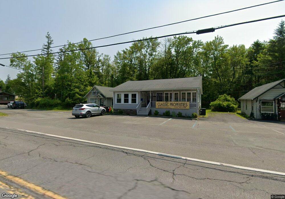
1124 Route 390 Cresco, PA 18326
Estimated Value: $250,721
2
Beds
1
Bath
416
Sq Ft
$603/Sq Ft
Est. Value
About This Home
This home is located at 1124 Route 390, Cresco, PA 18326 and is currently estimated at $250,721, approximately $602 per square foot. 1124 Route 390 is a home located in Monroe County with nearby schools including Swiftwater Interm School, Swiftwater Elementary Center, and Pocono Mountain East Junior High School.
Ownership History
Date
Name
Owned For
Owner Type
Purchase Details
Closed on
May 2, 2021
Sold by
Bahr Properties Inc
Bought by
Braven Holdings Llc
Current Estimated Value
Home Financials for this Owner
Home Financials are based on the most recent Mortgage that was taken out on this home.
Original Mortgage
$135,600
Interest Rate
3.1%
Mortgage Type
Future Advance Clause Open End Mortgage
Purchase Details
Closed on
Aug 26, 2010
Sold by
Cawolsky Raymond
Bought by
Bahr Properties Inc
Home Financials for this Owner
Home Financials are based on the most recent Mortgage that was taken out on this home.
Original Mortgage
$138,750
Interest Rate
4.57%
Mortgage Type
Commercial
Purchase Details
Closed on
Dec 28, 2006
Sold by
Jack Daniel Associates
Bought by
Cawolsky Raymond
Create a Home Valuation Report for This Property
The Home Valuation Report is an in-depth analysis detailing your home's value as well as a comparison with similar homes in the area
Home Values in the Area
Average Home Value in this Area
Purchase History
| Date | Buyer | Sale Price | Title Company |
|---|---|---|---|
| Braven Holdings Llc | $169,500 | Monroe Abstract Co | |
| Bahr Properties Inc | $185,000 | None Available | |
| Cawolsky Raymond | $195,000 | None Available |
Source: Public Records
Mortgage History
| Date | Status | Borrower | Loan Amount |
|---|---|---|---|
| Previous Owner | Braven Holdings Llc | $135,600 | |
| Previous Owner | Bahr Properties Inc | $138,750 |
Source: Public Records
Tax History Compared to Growth
Tax History
| Year | Tax Paid | Tax Assessment Tax Assessment Total Assessment is a certain percentage of the fair market value that is determined by local assessors to be the total taxable value of land and additions on the property. | Land | Improvement |
|---|---|---|---|---|
| 2025 | $1,581 | $199,880 | $84,450 | $115,430 |
| 2024 | $1,313 | $199,880 | $84,450 | $115,430 |
| 2023 | $5,231 | $199,880 | $84,450 | $115,430 |
| 2022 | $5,142 | $199,880 | $84,450 | $115,430 |
| 2021 | $5,142 | $199,880 | $84,450 | $115,430 |
| 2019 | $4,011 | $22,690 | $4,410 | $18,280 |
| 2018 | $4,586 | $22,690 | $4,410 | $18,280 |
| 2017 | $4,638 | $25,940 | $7,830 | $18,110 |
| 2016 | $1,077 | $25,940 | $7,830 | $18,110 |
| 2015 | -- | $25,940 | $7,830 | $18,110 |
| 2014 | -- | $25,940 | $7,830 | $18,110 |
Source: Public Records
Map
Nearby Homes
- 455 Laurel Pine Rd
- 781 White Oak Rd
- 371 Ridge Cir
- 612 Prices Dr
- 136 Oak Ln
- 519 Pheasant Ln
- 130 Barn Swallow Ln
- 104 Haverhill Rd
- 119 Falls Dr
- 6733 Route 191
- 136 Falls Dr
- 2138 Laurel Ln
- 2148 Laurel Ln
- 6683 Pennsylvania 191
- 122 Treetop Trail
- 664 Griscom Rd
- 6663 Pennsylvania 191
- 6656 Route 191
- 4130 Mill Creek Dr
- 606 Buck Cir
- 1124 Pennsylvania 390
- 1127 Route 390
- 1121 Pennsylvania 390
- 1121 Route 390
- 1108 Route 390
- 1121 Pennsylvania 390
- 401 Route 390
- 496 Laurel Pine Rd
- 1108 Pennsylvania 390
- 0 Golf Dr Unit PM-80024
- 0 Golf Dr
- 489 Laurel Pine Rd
- 1104 Pennsylvania 390
- 1104 Route 390- Unit 101 Route
- 1148 Pennsylvania 390
- 488 Laurel Pine Rd
- 1105 Route 390
- 110 Golf Dr
- 508 Prices Dr
- 486 Price Dr