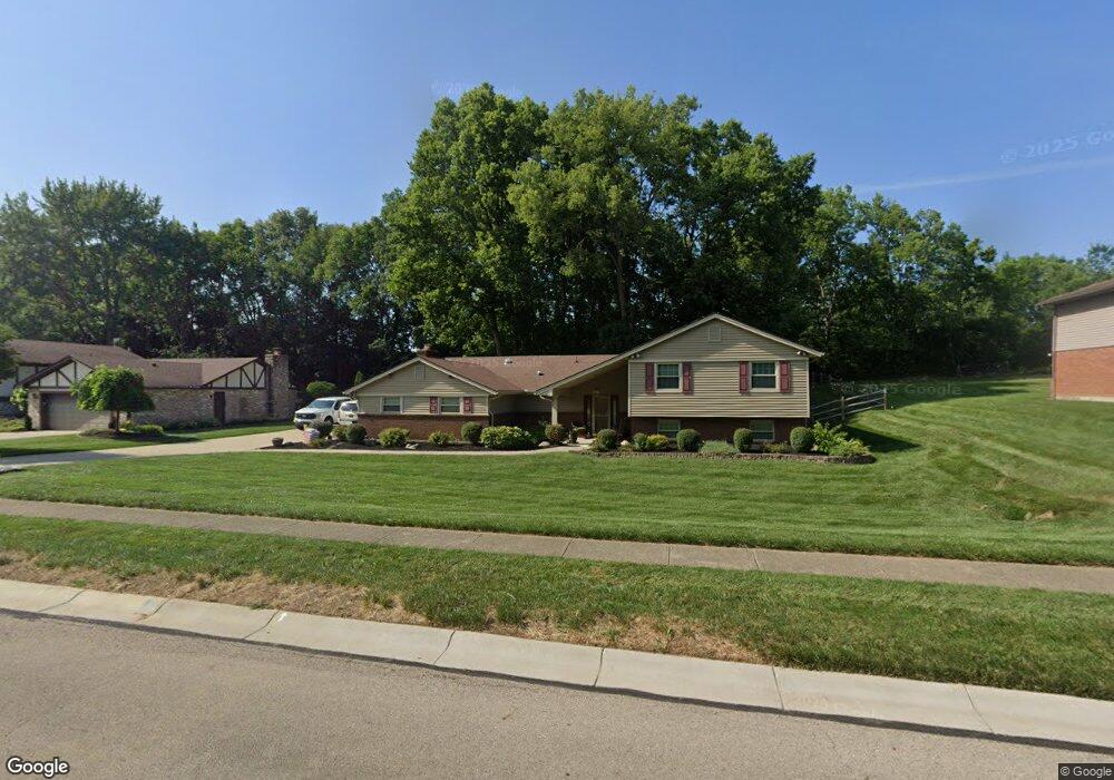
1125 Ambridge Rd Dayton, OH 45459
Estimated Value: $385,000 - $417,000
3
Beds
3
Baths
2,152
Sq Ft
$187/Sq Ft
Est. Value
About This Home
This home is located at 1125 Ambridge Rd, Dayton, OH 45459 and is currently estimated at $402,408, approximately $186 per square foot. 1125 Ambridge Rd is a home located in Montgomery County with nearby schools including Primary Village North, Stingley Elementary School, and Tower Heights Middle School.
Ownership History
Date
Name
Owned For
Owner Type
Purchase Details
Closed on
May 15, 2018
Sold by
Hall Kevin L and Hall Joanne M
Bought by
Hall Kevin L and Hall Joanne M
Current Estimated Value
Purchase Details
Closed on
Apr 12, 2001
Sold by
Nelson Roger J and Nelson Janet L
Bought by
Hall Kevin L and Hall Joanne M
Home Financials for this Owner
Home Financials are based on the most recent Mortgage that was taken out on this home.
Original Mortgage
$149,900
Interest Rate
7.03%
Mortgage Type
Unknown
Create a Home Valuation Report for This Property
The Home Valuation Report is an in-depth analysis detailing your home's value as well as a comparison with similar homes in the area
Home Values in the Area
Average Home Value in this Area
Purchase History
| Date | Buyer | Sale Price | Title Company |
|---|---|---|---|
| Hall Kevin L | -- | None Available | |
| Hall Kevin L | $187,900 | -- |
Source: Public Records
Mortgage History
| Date | Status | Borrower | Loan Amount |
|---|---|---|---|
| Closed | Hall Kevin L | $149,900 |
Source: Public Records
Tax History Compared to Growth
Tax History
| Year | Tax Paid | Tax Assessment Tax Assessment Total Assessment is a certain percentage of the fair market value that is determined by local assessors to be the total taxable value of land and additions on the property. | Land | Improvement |
|---|---|---|---|---|
| 2024 | $6,344 | $109,310 | $22,750 | $86,560 |
| 2023 | $6,344 | $109,310 | $22,750 | $86,560 |
| 2022 | $6,152 | $84,080 | $17,500 | $66,580 |
| 2021 | $6,169 | $84,080 | $17,500 | $66,580 |
| 2020 | $6,161 | $84,080 | $17,500 | $66,580 |
| 2019 | $6,426 | $78,290 | $17,500 | $60,790 |
| 2018 | $5,695 | $78,290 | $17,500 | $60,790 |
| 2017 | $5,629 | $78,290 | $17,500 | $60,790 |
| 2016 | $5,351 | $70,220 | $17,500 | $52,720 |
| 2015 | $5,296 | $70,220 | $17,500 | $52,720 |
| 2014 | $5,296 | $70,220 | $17,500 | $52,720 |
| 2012 | -- | $66,230 | $17,500 | $48,730 |
Source: Public Records
Map
Nearby Homes
- 7124 Fallen Oak Trace Unit 420
- 7308 Tamarind Trail
- 7129 Fallen Oak Trace Unit 839
- 1235 Chevington Ct Unit 1515
- 7111 Fallen Oak Trace Unit 1050
- 7128 Hartcrest Ln Unit 130130
- 7128 Hartcrest Ln Unit 130
- 7215 Whitetail Trail Unit 108108
- 7395 Cades Cove Unit 174174
- 1310 Hollow Run Unit 3
- 1311 Hollow Run Unit 11
- 1311 Hollow Run Unit 6
- 1501 Lake Pointe Way Unit 8
- 1511 Lake Pointe Way
- 1511 Lake Pointe Way Unit 2
- 6610 Green Branch Dr
- 1563 Langdon Dr
- 311 Pleasant Hill Dr
- 1973 Home Path Ct
- 6350 Gwinnett Ln Unit 1326
- 1101 Ambridge Rd
- 1151 Ambridge Rd
- 1095 Ambridge Rd
- 1126 Ambridge Rd
- 1175 Ambridge Rd
- 1102 Ambridge Rd
- 1152 Ambridge Rd
- 1096 Ambridge Rd
- 1075 Ambridge Rd
- 1176 Ambridge Rd
- 1195 Ambridge Rd
- 7050 Forest Brook Blvd
- 1120 Fox Chase Ct
- 1196 Ambridge Rd
- 1110 Fox Chase Ct
- 1051 Ambridge Rd
- 1225 Ambridge Rd
- 7070 Forest Brook Blvd
- 1130 Fox Chase Ct
- 1226 Ambridge Rd