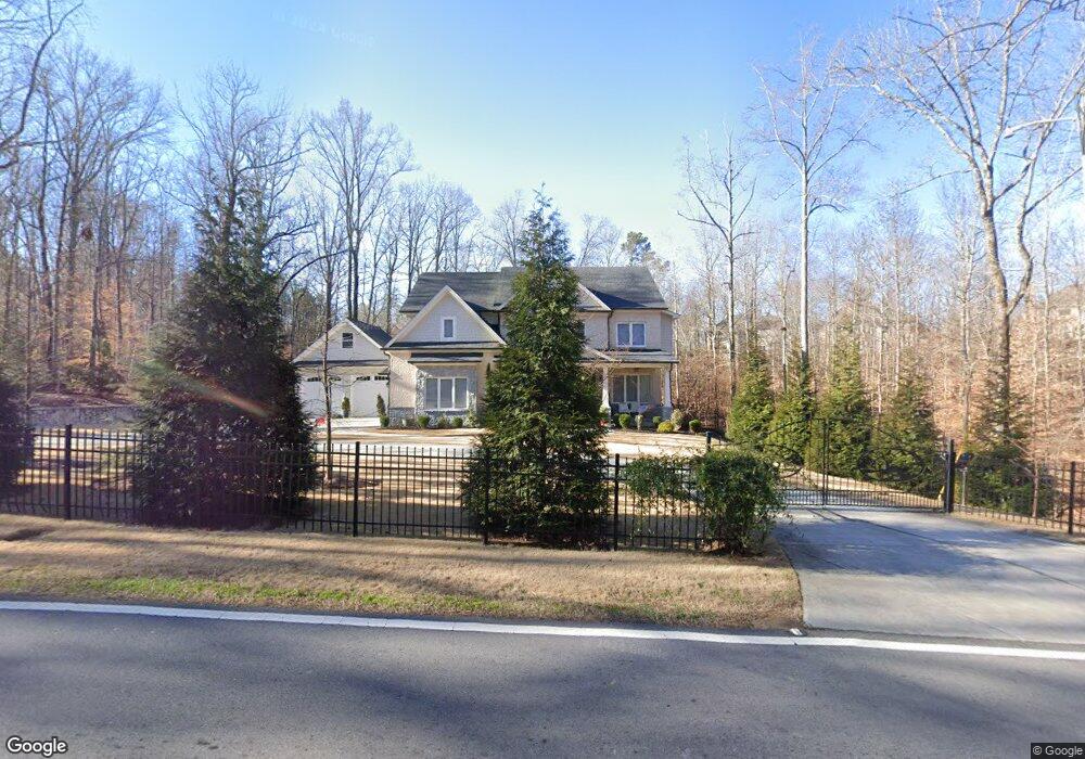
1125 Buford Dam Rd Buford, GA 30518
Estimated Value: $1,001,390 - $1,184,000
5
Beds
5
Baths
6,080
Sq Ft
$182/Sq Ft
Est. Value
About This Home
This home is located at 1125 Buford Dam Rd, Buford, GA 30518 and is currently estimated at $1,104,348, approximately $181 per square foot. 1125 Buford Dam Rd is a home located in Gwinnett County with nearby schools including White Oak Elementary School, Lanier Middle School, and Lanier High School.
Ownership History
Date
Name
Owned For
Owner Type
Purchase Details
Closed on
May 12, 2021
Sold by
Aiden Proprties Llc
Bought by
Popovich Emanuel and Popovich Mihaela
Current Estimated Value
Purchase Details
Closed on
Oct 29, 2016
Sold by
Aiden Properties Llc
Bought by
Popovich Emanuel
Purchase Details
Closed on
Jul 24, 2009
Sold by
Popovich Emanuel
Bought by
Aiden Properties Llc
Purchase Details
Closed on
Dec 7, 2006
Sold by
Able & Realty Investments
Bought by
Popovich Emanuel
Purchase Details
Closed on
Jan 30, 2004
Sold by
England William G and England Betty S
Bought by
Weiller William
Create a Home Valuation Report for This Property
The Home Valuation Report is an in-depth analysis detailing your home's value as well as a comparison with similar homes in the area
Home Values in the Area
Average Home Value in this Area
Purchase History
| Date | Buyer | Sale Price | Title Company |
|---|---|---|---|
| Popovich Emanuel | -- | -- | |
| Popovich Emanuel | -- | -- | |
| Aiden Properties Llc | -- | -- | |
| Popovich Emanuel | $95,000 | -- | |
| Weiller William | $120,000 | -- |
Source: Public Records
Tax History Compared to Growth
Tax History
| Year | Tax Paid | Tax Assessment Tax Assessment Total Assessment is a certain percentage of the fair market value that is determined by local assessors to be the total taxable value of land and additions on the property. | Land | Improvement |
|---|---|---|---|---|
| 2025 | $10,537 | $352,360 | $26,160 | $326,200 |
| 2024 | $10,724 | $352,360 | $26,160 | $326,200 |
| 2023 | $10,724 | $352,360 | $26,160 | $326,200 |
| 2022 | $0 | $236,640 | $15,280 | $221,360 |
| 2021 | $8,467 | $236,640 | $15,280 | $221,360 |
| 2020 | $8,158 | $261,840 | $15,280 | $246,560 |
| 2019 | $7,773 | $219,720 | $12,880 | $206,840 |
| 2018 | $417 | $11,880 | $11,880 | $0 |
| 2016 | $339 | $9,680 | $9,680 | $0 |
| 2015 | $343 | $9,680 | $9,680 | $0 |
| 2014 | -- | $11,760 | $11,760 | $0 |
Source: Public Records
Map
Nearby Homes
- 6670 Island Pointe Dr
- The Danbury C Plan at Melody Lakeside Estates
- The Hampton B Plan at Melody Lakeside Estates
- The Hickory B Plan at Melody Lakeside Estates
- 6944 Melody Ridge Rd
- 6935 Melody Ridge Rd
- 6945 Melody Ridge Rd
- 6597 River Island Dr
- 1000 Island Bluff Ln Unit 1
- 1038 Island View Ct Unit 2
- 932 Homepark Cir
- 942 Homepark Cir
- 972 Homepark Cir
- 1114 Blue Water Ct
- 6427 Blue Water Dr
- 6437 Blue Water Dr
- 6479 Mobilis Ct
- 852 van Briggle Path
- 3875 Sweetwater Dr
- 6385 Grand Magnolia Dr
- 1125 Buford Dam Rd Unit 6
- 1133 Buford Dam Rd
- 6766 Pannell Rd
- 6735 Pannell Rd
- 6755 Pannell Rd Unit 3
- 6755 Pannell Rd
- 6765 Pannell Rd
- 6775 Pannell Rd
- 6776 Pannell Rd
- 6745 Pannell Rd
- 6725 Pannell Rd
- 6781 Pannell Rd
- 1130 Buford Dam Rd
- 1140 Buford Dam Rd
- 6720 Pannell Rd
- 6760 Pannell Rd
- 6770 Pannell Rd
- 6787 Pannell Rd
- 00 Pannell Rd
- 0 Pannell Rd