


1125 Dodson Way Sparks, NV 89431
North Rock NeighborhoodEstimated payment $2,323/month
Highlights
- Separate Formal Living Room
- 1 Car Attached Garage
- Laundry Room
- No HOA
- Double Pane Windows
- No Interior Steps
About This Home
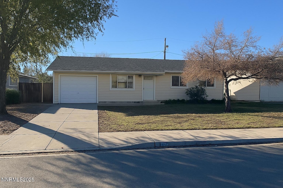
Welcome to your Sparks sanctuary! This charming 3-bedroom, 1-bath single-story home offers the perfect blend of comfort, functionality, and potential—all in a location that puts you close to everything. Recently refreshed from top to bottom, you'll love the all-new interior paint, brand-new flooring throughout, and a brand-new roof offering peace of mind for years to come. Step inside to a bright, open living space that flows seamlessly into the dining area, where natural light pours through double-pane windows. The newly renovated kitchen is a showstopper—featuring fresh cabinetry, updated counters, and ample storage, making it ideal for both quick weekday meals and weekend gatherings. The updated bathroom boasts modern tilework and a clean, airy feel, while the three bedrooms offer cozy retreats for rest, work, or play. Outside, the large fenced backyard is a blank canvas—whether you envision a lush garden, play space, or private entertaining area, there's room to make it yours. The attached garage and driveway provide convenient parking, and the level lot makes for easy maintenance. Located in the established Greenbrae Terrace neighborhood, you'll enjoy quick access to schools, parks, shopping, and dining, with all the energy and amenities of Sparks just minutes away. Whether you're a first-time buyer, downsizing, or looking for an investment, this home delivers style, comfort, and opportunity. Don't miss your chance to create the lifestyle you've been envisioning—schedule your showing today!
Home Details
Home Type
- Single Family
Est. Annual Taxes
- $1,437
Year Built
- Built in 1959
Lot Details
- 6,316 Sq Ft Lot
- Back Yard Fenced
- Level Lot
- Property is zoned SF-6
Parking
- 1 Car Attached Garage
- Parking Pad
Home Design
- Slab Foundation
- Pitched Roof
- Shingle Roof
- Composition Roof
- Vinyl Siding
- Stick Built Home
Interior Spaces
- 1,044 Sq Ft Home
- 1-Story Property
- Ceiling Fan
- Double Pane Windows
- Vinyl Clad Windows
- Separate Formal Living Room
- Combination Kitchen and Dining Room
- Laundry Room
Kitchen
- Dishwasher
- No Kitchen Appliances
- Disposal
Flooring
- Carpet
- Luxury Vinyl Tile
Bedrooms and Bathrooms
- 3 Bedrooms
- 1 Full Bathroom
- Bathtub and Shower Combination in Primary Bathroom
Accessible Home Design
- No Interior Steps
Schools
- Maxwell Elementary School
- Sparks Middle School
- Sparks High School
Utilities
- No Cooling
- Forced Air Heating System
- Gas Water Heater
- Internet Available
- Phone Available
- Cable TV Available
Community Details
- No Home Owners Association
- Sparks Community
- Green Brae Terrace Westerly Addition H Subdivision
- The community has rules related to covenants, conditions, and restrictions
Listing and Financial Details
- Court or third-party approval is required for the sale
- Assessor Parcel Number 027-233-20
Map
Home Values in the Area
Average Home Value in this Area
Tax History
| Year | Tax Paid | Tax Assessment Tax Assessment Total Assessment is a certain percentage of the fair market value that is determined by local assessors to be the total taxable value of land and additions on the property. | Land | Improvement |
|---|---|---|---|---|
| 2025 | $1,437 | $46,064 | $31,325 | $14,739 |
| 2024 | $1,437 | $44,600 | $30,100 | $14,501 |
| 2023 | $684 | $43,326 | $29,890 | $13,436 |
| 2022 | $634 | $36,050 | $25,095 | $10,955 |
| 2021 | $1,602 | $27,427 | $16,765 | $10,662 |
| 2020 | $569 | $26,808 | $16,345 | $10,463 |
| 2019 | $542 | $25,794 | $15,890 | $9,904 |
| 2018 | $518 | $20,723 | $11,235 | $9,488 |
| 2017 | $497 | $19,462 | $10,150 | $9,312 |
| 2016 | $484 | $17,557 | $8,225 | $9,332 |
| 2015 | $484 | $16,405 | $7,140 | $9,265 |
| 2014 | $469 | $15,170 | $6,440 | $8,730 |
| 2013 | -- | $12,467 | $3,955 | $8,512 |
Property History
| Date | Event | Price | List to Sale | Price per Sq Ft |
|---|---|---|---|---|
| 09/18/2025 09/18/25 | Price Changed | $420,000 | -1.2% | $402 / Sq Ft |
| 08/21/2025 08/21/25 | For Sale | $425,000 | -- | $407 / Sq Ft |
Purchase History
| Date | Type | Sale Price | Title Company |
|---|---|---|---|
| Interfamily Deed Transfer | -- | Stewart Title |
Mortgage History
| Date | Status | Loan Amount | Loan Type |
|---|---|---|---|
| Closed | $75,850 | No Value Available |
Source: Northern Nevada Regional MLS
MLS Number: 250054895
APN: 027-233-20
Disclaimer: Certain information contained herein is derived from information provided by parties other than Homes.com. All information provided is deemed reliable, but is not guaranteed to be accurate and should be independently verified.
![]() IDX information is provided exclusively for personal, non-commercial use, and may not be used for any purpose other than to identify prospective properties consumers may be interested in purchasing. Information is deemed reliable but not guaranteed. The content relating to real estate for sale on this web site comes in part from the Broker Reciprocity/ IDX program of the Northern Nevada Regional Multiple Listing Service°. Real estate listings held by brokerage firms other than Ten-X are marked with the Broker Reciprocity logo and detailed information about those listings includes the name of the listing brokerage. Any use of the content other than by a search performed by a consumer looking to purchase or rent real estate is prohibited. © 2025 Northern Nevada Regional Multiple Listing Service® MLS. All rights reserved.
IDX information is provided exclusively for personal, non-commercial use, and may not be used for any purpose other than to identify prospective properties consumers may be interested in purchasing. Information is deemed reliable but not guaranteed. The content relating to real estate for sale on this web site comes in part from the Broker Reciprocity/ IDX program of the Northern Nevada Regional Multiple Listing Service°. Real estate listings held by brokerage firms other than Ten-X are marked with the Broker Reciprocity logo and detailed information about those listings includes the name of the listing brokerage. Any use of the content other than by a search performed by a consumer looking to purchase or rent real estate is prohibited. © 2025 Northern Nevada Regional Multiple Listing Service® MLS. All rights reserved.
- 1160 York Way
- 1345 Plymouth Way
- 1110 Xman Way
- 0 N Mccarran Blvd Unit 250052909
- 3269 Valley Forge Way
- 3252 Holman Way
- 1595 York Way
- 1023 Tyler Way
- 2154 Oppio St
- 1124 Sbragia Way
- 1665 London Cir
- 1731 Gault Way Unit D
- 780 Emerson Way
- 1003 Sbragia Way
- 1655 Byrd Dr
- 5530 High Rock Way
- 465 Lenwood Dr
- 1121 Greenbrae Dr
- 1365 Prospect Ave
- 1945 4th St Unit 32
- 1501 Gault Way
- 2340 Logan Way
- 1530 Chester Square
- 1530 Chester Square Unit Chester
- 953 Lepori Way
- 1799 York Way
- 1695 Trabert Way
- 489 Penny Way
- 1864 19th St
- 1305 Pyramid Way
- 1100 15th St
- 1260 Commerce St
- 1800 Sullivan Ln
- 1835 Oddie Blvd
- 1080-1098 Rock Blvd
- 3550 Mashie Dr Unit 1
- 3116 Sterling Ridge Cir
- 1600 I St Unit 2205
- 1600 I St Unit 1305
- 1600 I St Unit 1105
