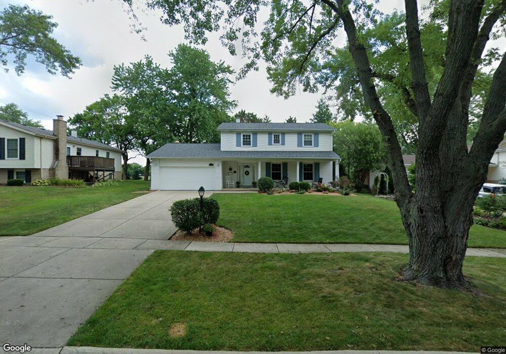
1126 69th St Darien, IL 60561
Estimated Value: $463,734 - $573,000
Studio
--
Bath
2,141
Sq Ft
$240/Sq Ft
Est. Value
About This Home
This home is located at 1126 69th St, Darien, IL 60561 and is currently estimated at $513,684, approximately $239 per square foot. 1126 69th St is a home located in DuPage County with nearby schools including Mark Delay School, Lace Elementary School, and Eisenhower Jr High School.
Ownership History
Date
Name
Owned For
Owner Type
Purchase Details
Closed on
Apr 29, 1998
Sold by
Scheidt Steven K and Scheidt Darla J
Bought by
Scheidt Steven K and Scheidt Darla J
Current Estimated Value
Purchase Details
Closed on
Dec 15, 1994
Sold by
Soldato Carmen D and Soldato Deborah S
Bought by
Scheidt Steven K and Scheidt Darla J
Home Financials for this Owner
Home Financials are based on the most recent Mortgage that was taken out on this home.
Original Mortgage
$124,000
Outstanding Balance
$71,743
Interest Rate
9.06%
Estimated Equity
$441,941
Create a Home Valuation Report for This Property
The Home Valuation Report is an in-depth analysis detailing your home's value as well as a comparison with similar homes in the area
Home Values in the Area
Average Home Value in this Area
Purchase History
| Date | Buyer | Sale Price | Title Company |
|---|---|---|---|
| Scheidt Steven K | -- | -- | |
| Scheidt Steven K | $177,000 | -- |
Source: Public Records
Mortgage History
| Date | Status | Borrower | Loan Amount |
|---|---|---|---|
| Open | Scheidt Steven K | $124,000 |
Source: Public Records
Tax History
| Year | Tax Paid | Tax Assessment Tax Assessment Total Assessment is a certain percentage of the fair market value that is determined by local assessors to be the total taxable value of land and additions on the property. | Land | Improvement |
|---|---|---|---|---|
| 2024 | $8,961 | $147,071 | $45,916 | $101,155 |
| 2023 | $8,633 | $135,200 | $42,210 | $92,990 |
| 2022 | $8,463 | $132,420 | $41,340 | $91,080 |
| 2021 | $8,142 | $130,910 | $40,870 | $90,040 |
| 2020 | $8,033 | $128,320 | $40,060 | $88,260 |
| 2019 | $7,767 | $123,130 | $38,440 | $84,690 |
| 2018 | $7,206 | $115,550 | $38,250 | $77,300 |
| 2017 | $7,137 | $111,190 | $36,810 | $74,380 |
| 2016 | $6,953 | $106,120 | $35,130 | $70,990 |
| 2015 | $6,856 | $99,840 | $33,050 | $66,790 |
| 2014 | $6,476 | $93,390 | $32,130 | $61,260 |
| 2013 | $6,261 | $92,950 | $31,980 | $60,970 |
Source: Public Records
Map
Nearby Homes
- 6808 Scotch Pine Trail
- 1013 Torrey Pines Ct
- 1156 Bristlecone Ct
- 1109 Ponderosa Ct
- 18W089 Claremont Dr
- 1543 Apple Grove Ln
- 1515 Apple Grove Ln
- 7209 Grant St
- 18W025 73rd St
- 47 W Pier Dr Unit 102
- 73 W Pier Dr Unit 201
- 107 65th Lake Dr Unit 202
- 1313 Cass Ln E Unit 302
- 1614 Darien Club Dr
- 1224 Ridge Rd
- 6136 Bentley Ave
- 1447 Coventry Ct
- 6722 Sweetbriar Ln
- 1524 Brittany Ct
- 401 69th St
- 1130 69th St
- 1122 69th St
- 1118 69th St
- 1125 69th St
- 1129 69th St
- 1121 69th St
- 1117 69th St
- 1114 69th St
- 6821 White Pine Trail
- 1113 69th St
- 1122 Hinsbrook Ave
- 1110 69th St
- 1130 Hinsbrook Ave
- 6817 White Pine Trail
- 1109 69th St
- 1118 Hinsbrook Ave
- 1106 69th St
- 1114 Hinsbrook Ave
- 6808 White Pine Trail
- 6813 White Pine Trail
Your Personal Tour Guide
Ask me questions while you tour the home.