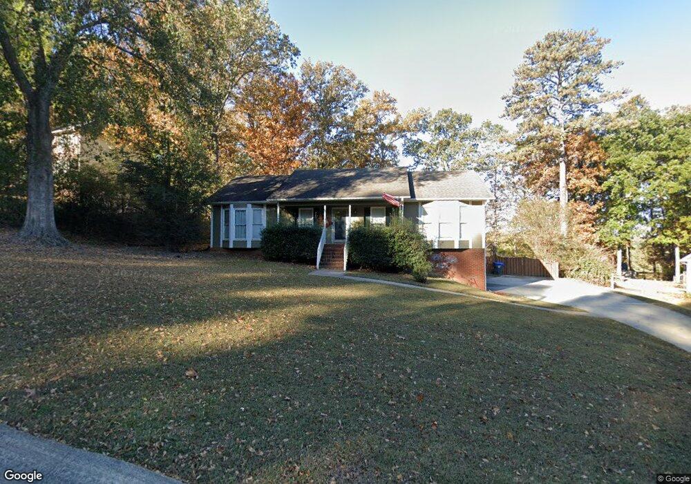
1127 Independence Dr Alabaster, AL 35007
Estimated Value: $280,802 - $314,000
--
Bed
1
Bath
1,622
Sq Ft
$180/Sq Ft
Est. Value
About This Home
This home is located at 1127 Independence Dr, Alabaster, AL 35007 and is currently estimated at $291,701, approximately $179 per square foot. 1127 Independence Dr is a home located in Shelby County with nearby schools including Thompson Intermediate School, Thompson Middle School, and Thompson High School.
Ownership History
Date
Name
Owned For
Owner Type
Purchase Details
Closed on
Nov 17, 2015
Sold by
Bright Larry T
Bought by
Martin Bradley J and Martin Lindsey
Current Estimated Value
Home Financials for this Owner
Home Financials are based on the most recent Mortgage that was taken out on this home.
Original Mortgage
$165,750
Outstanding Balance
$128,853
Interest Rate
3.87%
Mortgage Type
FHA
Estimated Equity
$162,848
Purchase Details
Closed on
Oct 4, 2012
Sold by
Bright Larry T and Coogan Dorothy
Bought by
Bright Larry T
Purchase Details
Closed on
Feb 14, 2000
Sold by
Crusco Joseph J and Crusco Gina M
Bought by
Bright Larry T
Home Financials for this Owner
Home Financials are based on the most recent Mortgage that was taken out on this home.
Original Mortgage
$137,700
Interest Rate
8%
Create a Home Valuation Report for This Property
The Home Valuation Report is an in-depth analysis detailing your home's value as well as a comparison with similar homes in the area
Home Values in the Area
Average Home Value in this Area
Purchase History
| Date | Buyer | Sale Price | Title Company |
|---|---|---|---|
| Martin Bradley J | $168,900 | None Available | |
| Bright Larry T | $500 | None Available | |
| Bright Larry T | -- | -- |
Source: Public Records
Mortgage History
| Date | Status | Borrower | Loan Amount |
|---|---|---|---|
| Open | Martin Bradley J | $165,750 | |
| Previous Owner | Bright Larry T | $137,700 |
Source: Public Records
Tax History Compared to Growth
Tax History
| Year | Tax Paid | Tax Assessment Tax Assessment Total Assessment is a certain percentage of the fair market value that is determined by local assessors to be the total taxable value of land and additions on the property. | Land | Improvement |
|---|---|---|---|---|
| 2024 | $1,304 | $24,140 | $0 | $0 |
| 2023 | $1,157 | $22,180 | $0 | $0 |
| 2022 | $1,108 | $21,280 | $0 | $0 |
| 2021 | $974 | $18,800 | $0 | $0 |
| 2020 | $904 | $17,500 | $0 | $0 |
| 2019 | $834 | $16,200 | $0 | $0 |
| 2017 | $778 | $15,160 | $0 | $0 |
| 2015 | $778 | $14,400 | $0 | $0 |
| 2014 | $760 | $14,080 | $0 | $0 |
Source: Public Records
Map
Nearby Homes
- 1121 Colonial Dr
- 1445 Sequoia Trail
- 1910 Amberley Woods Trail
- 1909 Amberley Woods Trail
- 105 Acorn Cir
- 1117 Amberley Woods Dr
- 100 Cape Cod Cir
- 152 Roy Ct
- 112 Portsouth Ln
- 2916 Dublin Dr N
- 1445 Navajo Trail
- 1514 Timber Dr
- 204 Portsouth Ln
- 6025 Woodvale Ct
- 225 Portsouth Ln
- 905 Navajo Trail
- 231 Hickory Point Ln
- 1317 W Navajo Dr
- 0001 9th St NW
- 000 9th St NW
- 1129 Independence Dr
- 1125 Independence Dr
- 1056 Independence Ct
- 1054 Independence Ct
- 1131 Independence Dr
- 1123 Independence Dr
- 1122 Independence Dr
- 1124 Independence Dr
- 1058 Independence Ct
- 1120 Independence Dr
- 1052 Independence Ct
- 1126 Independence Dr
- 1118 Independence Dr
- 1133 Independence Dr
- 1121 Independence Dr
- 1060 Independence Ct
- 1050 Independence Ct
- 1128 Independence Dr
- 1116 Independence Dr
- 1109 Elm Dr