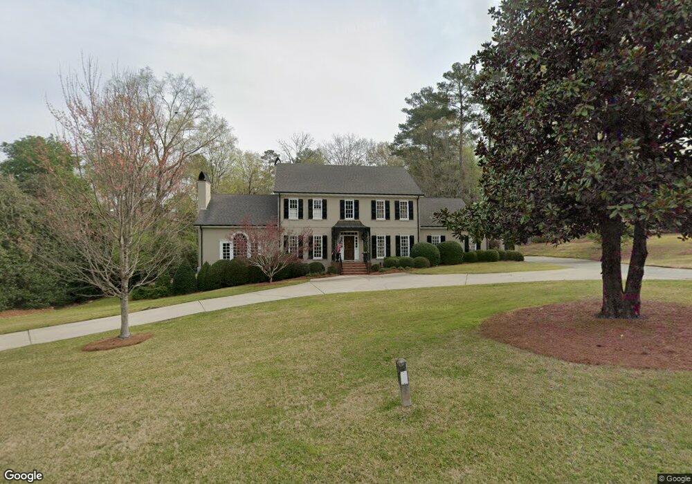
1127 Saint Andrews Dr Macon, GA 31210
Estimated Value: $822,000 - $865,000
4
Beds
4
Baths
4,025
Sq Ft
$208/Sq Ft
Est. Value
About This Home
This home is located at 1127 Saint Andrews Dr, Macon, GA 31210 and is currently estimated at $838,280, approximately $208 per square foot. 1127 Saint Andrews Dr is a home located in Bibb County with nearby schools including Carter Elementary School, Howard Middle School, and Howard High School.
Ownership History
Date
Name
Owned For
Owner Type
Purchase Details
Closed on
Mar 1, 2023
Sold by
Buzzell R William
Bought by
Delladonna Jody A
Current Estimated Value
Home Financials for this Owner
Home Financials are based on the most recent Mortgage that was taken out on this home.
Original Mortgage
$444,000
Outstanding Balance
$429,107
Interest Rate
6.15%
Mortgage Type
New Conventional
Estimated Equity
$409,173
Purchase Details
Closed on
Nov 2, 1981
Sold by
Halliburton 1397 T H and 436 H
Bought by
Buzzell R William Ii -
Create a Home Valuation Report for This Property
The Home Valuation Report is an in-depth analysis detailing your home's value as well as a comparison with similar homes in the area
Purchase History
| Date | Buyer | Sale Price | Title Company |
|---|---|---|---|
| Delladonna Jody A | $748,000 | -- | |
| Buzzell R William Ii - | $138,800 | -- |
Source: Public Records
Mortgage History
| Date | Status | Borrower | Loan Amount |
|---|---|---|---|
| Open | Delladonna Jody A | $444,000 |
Source: Public Records
Tax History
| Year | Tax Paid | Tax Assessment Tax Assessment Total Assessment is a certain percentage of the fair market value that is determined by local assessors to be the total taxable value of land and additions on the property. | Land | Improvement |
|---|---|---|---|---|
| 2025 | $6,193 | $252,014 | $60,480 | $191,534 |
| 2024 | $6,400 | $252,014 | $60,480 | $191,534 |
| 2023 | $6,507 | $226,686 | $60,480 | $166,206 |
| 2022 | $6,193 | $185,879 | $28,800 | $157,079 |
| 2021 | $6,427 | $176,128 | $28,800 | $147,328 |
| 2020 | $6,115 | $164,502 | $24,000 | $140,502 |
| 2019 | $5,669 | $151,824 | $24,000 | $127,824 |
| 2018 | $8,862 | $151,824 | $24,000 | $127,824 |
| 2017 | $5,426 | $151,824 | $24,000 | $127,824 |
| 2016 | $5,011 | $151,824 | $24,000 | $127,824 |
| 2015 | $7,093 | $151,824 | $24,000 | $127,824 |
| 2014 | $7,104 | $151,824 | $24,000 | $127,824 |
Source: Public Records
Map
Nearby Homes
- 4716 Moor Park
- 117 Legare Ct
- 4697 Brae Burn Ln
- 520 Old Club Rd S
- 658 Tucker Rd
- 764 Kings Mountain Rd
- 211 Old Club Ct
- 150 Tucker Rd
- 120 Idle Hour Dr
- 4555 Old Club Rd
- 222 Rutledge Way
- 5252 Brandywine Dr
- 4618 Lakewood Ave
- 4571 Shadow Lawn Dr
- 776 Ivy Brook Way
- 120 Woodmere Trail
- 112 Covington Place
- 110 Woodmere Trail
- 176 Cold Creek Pkwy
- 4433 Azalea Dr
- 1123 Saint Andrews Dr
- 100 Prestwick Park
- 1128 Saint Andrews Dr
- 1115 Saint Andrews Dr
- 1124 Saint Andrews Dr
- 1132 Saint Andrews Dr
- 104 Prestwick Park
- 1136 Saint Andrews Dr
- 1120 Saint Andrews Dr
- 111 Prestwick Park
- 1111 Saint Andrews Dr
- 197 Gleneagles Cir
- 102 Troon Way
- 1140 Saint Andrews Dr
- 1140 St Andrews Dr
- 193 Gleneagles Cir
- 1112 Saint Andrews Dr
- 109 Gleneagles Cir
- 1112 St Andrews Dr
- 1141 Saint Andrews Dr
Your Personal Tour Guide
Ask me questions while you tour the home.