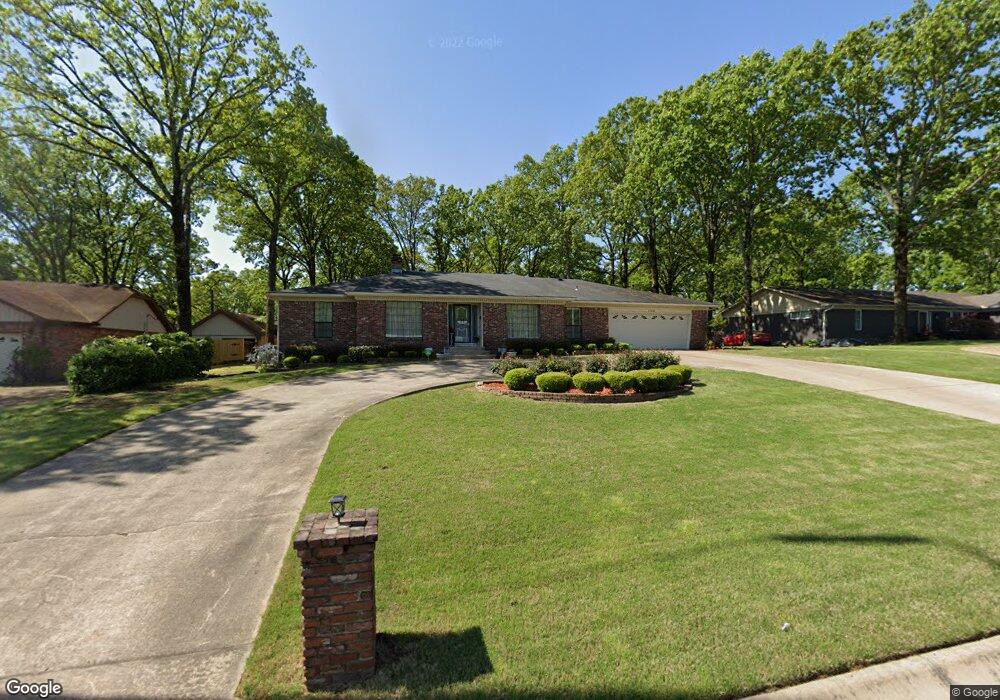
1128 Club Rd Sherwood, AR 72120
Estimated Value: $288,000 - $322,000
--
Bed
4
Baths
2,681
Sq Ft
$113/Sq Ft
Est. Value
About This Home
This home is located at 1128 Club Rd, Sherwood, AR 72120 and is currently estimated at $303,000, approximately $113 per square foot. 1128 Club Rd is a home located in Pulaski County with nearby schools including Sherwood Elementary School, Sylvan Hills Middle School, and Sylvan Hills High School.
Ownership History
Date
Name
Owned For
Owner Type
Purchase Details
Closed on
Jan 19, 2021
Sold by
Clark William David and Harris Marilyn Kay
Bought by
Harris Marilyn Kay and Marilyn Kay Harris Trust
Current Estimated Value
Purchase Details
Closed on
Mar 14, 2013
Sold by
Ramsey Joyce
Bought by
Ramsey Joyce
Purchase Details
Closed on
Jun 27, 2002
Sold by
Ramsey Guy E and Ramsey Joyce
Bought by
Ramsey Guy E and Ramsey Joyce
Create a Home Valuation Report for This Property
The Home Valuation Report is an in-depth analysis detailing your home's value as well as a comparison with similar homes in the area
Home Values in the Area
Average Home Value in this Area
Purchase History
| Date | Buyer | Sale Price | Title Company |
|---|---|---|---|
| Harris Marilyn Kay | -- | None Available | |
| Ramsey Joyce | -- | None Available | |
| Ramsey Guy E | -- | -- |
Source: Public Records
Tax History Compared to Growth
Tax History
| Year | Tax Paid | Tax Assessment Tax Assessment Total Assessment is a certain percentage of the fair market value that is determined by local assessors to be the total taxable value of land and additions on the property. | Land | Improvement |
|---|---|---|---|---|
| 2025 | $1,986 | $58,188 | $6,600 | $51,588 |
| 2024 | $1,703 | $58,188 | $6,600 | $51,588 |
| 2023 | $1,703 | $58,188 | $6,600 | $51,588 |
| 2022 | $1,861 | $58,188 | $6,600 | $51,588 |
| 2021 | $1,622 | $42,180 | $6,000 | $36,180 |
| 2020 | $1,237 | $42,180 | $6,000 | $36,180 |
| 2019 | $1,237 | $42,180 | $6,000 | $36,180 |
| 2018 | $1,262 | $42,180 | $6,000 | $36,180 |
| 2017 | $1,234 | $42,180 | $6,000 | $36,180 |
| 2016 | $1,234 | $38,990 | $6,600 | $32,390 |
| 2015 | $1,384 | $27,245 | $6,600 | $20,645 |
| 2014 | $1,384 | $27,245 | $6,600 | $20,645 |
Source: Public Records
Map
Nearby Homes
- 11 Daniel Dr
- 4636 Brandywine Cove
- +/- 8.16 Acres Windchime Ave
- 8000 Pinto Trail
- 1800 Palomino Dr
- 1301 Stafford Rd
- 1300 Stafford Rd
- 619 Newcastle Dr
- 1415 Stafford Rd
- 626 Newcastle Dr
- 609 Newcastle Dr
- 622 Newcastle Dr
- 1419 Stafford Rd
- 618 & 620 Newcastle Dr
- 610 Newcastle Dr
- 1423 Stafford Rd
- 615 & 617 Brierly Dr
- 615 Brierly Dr
- 1501 Stafford Rd
- 8320 Holiday Dr