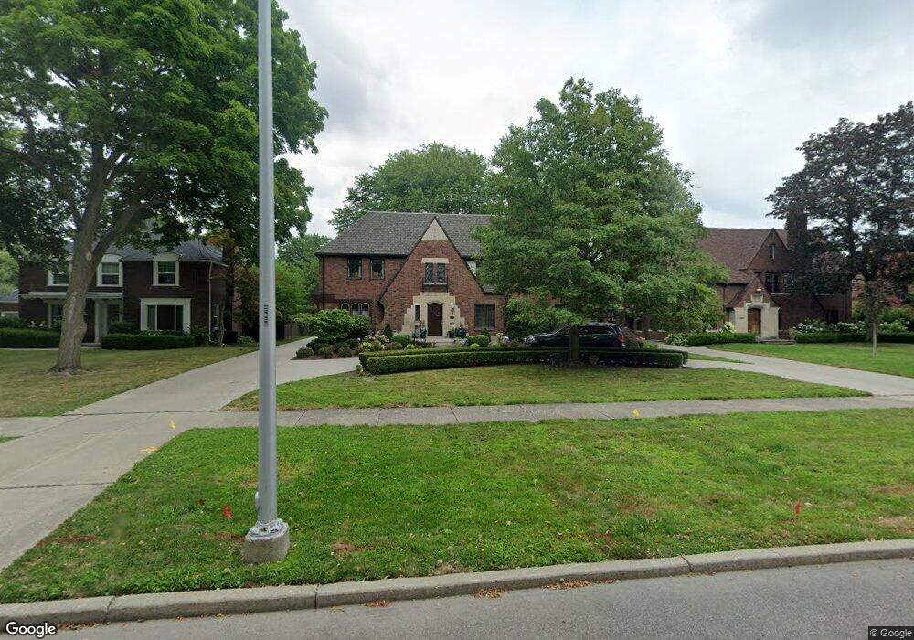
1128 Devonshire Rd Grosse Pointe Park, MI 48230
Estimated Value: $1,112,450 - $1,330,000
5
Beds
5
Baths
5,465
Sq Ft
$225/Sq Ft
Est. Value
About This Home
This home is located at 1128 Devonshire Rd, Grosse Pointe Park, MI 48230 and is currently estimated at $1,228,150, approximately $224 per square foot. 1128 Devonshire Rd is a home located in Wayne County with nearby schools including George Defer Elementary School, Pierce Middle School, and Grosse Pointe South High School.
Ownership History
Date
Name
Owned For
Owner Type
Purchase Details
Closed on
Jun 9, 2015
Sold by
Stoup Linda
Bought by
Stoup Linda S and Linda S Stoup Living Trust
Current Estimated Value
Purchase Details
Closed on
Nov 13, 2014
Sold by
Stoup Frank Linwood
Bought by
Whitmer Linda Sue
Purchase Details
Closed on
Jun 29, 2011
Sold by
Ruffner Frederic G and Ruffner Catherine Parrott
Bought by
Stoup Frank and Stoup Linda
Purchase Details
Closed on
Dec 4, 1996
Sold by
Sh Madeline H and Sh Edward J
Bought by
Feigelson Clifford and Feigelson Sheri
Create a Home Valuation Report for This Property
The Home Valuation Report is an in-depth analysis detailing your home's value as well as a comparison with similar homes in the area
Home Values in the Area
Average Home Value in this Area
Purchase History
| Date | Buyer | Sale Price | Title Company |
|---|---|---|---|
| Stoup Linda S | -- | Attorney | |
| Whitmer Linda Sue | -- | None Available | |
| Stoup Frank | $545,000 | Greco | |
| Feigelson Clifford | $400,000 | -- |
Source: Public Records
Tax History
| Year | Tax Paid | Tax Assessment Tax Assessment Total Assessment is a certain percentage of the fair market value that is determined by local assessors to be the total taxable value of land and additions on the property. | Land | Improvement |
|---|---|---|---|---|
| 2025 | $8,332 | $542,300 | $0 | $0 |
| 2024 | $8,020 | $512,600 | $0 | $0 |
| 2023 | $7,659 | $466,600 | $0 | $0 |
| 2022 | $7,276 | $425,300 | $0 | $0 |
| 2021 | $14,347 | $396,900 | $0 | $0 |
| 2019 | $14,764 | $361,400 | $0 | $0 |
| 2018 | $6,937 | $316,300 | $0 | $0 |
| 2017 | $15,089 | $272,400 | $0 | $0 |
| 2016 | $14,277 | $337,800 | $0 | $0 |
| 2015 | $25,961 | $311,900 | $0 | $0 |
| 2013 | $25,150 | $256,700 | $0 | $0 |
| 2012 | $7,260 | $272,900 | $65,500 | $207,400 |
Source: Public Records
Map
Nearby Homes
- 1206 Balfour St
- 1338 Somerset Ave
- 1254 Beaconsfield Ave
- 943 Harcourt Rd Unit 45
- 3430 Bedford St
- 3460 Bedford St
- 1048 Lakepointe St Unit A
- 1264 Bishop Rd
- 1083 Lakepointe St
- 1328 Lakepointe St
- 74 Pointe Park Place Unit 311
- 32 Pointe Park Place Unit 31
- 26 Pointe Park Place Unit 303
- 1030 Bishop Rd
- 1417 Beaconsfield Ave
- 1239 Maryland St
- 3520 Audubon Rd
- 815 Harcourt Rd Unit 2
- 814 Harcourt Rd Unit 816
- 3675 Bedford St
- 1138 Devonshire Rd
- 1120 Devonshire Rd
- 1127 Bedford Rd
- 1135 Bedford Rd
- 1112 Devonshire Rd
- 1119 Bedford Rd
- 1145 Bedford Rd
- 1113 Bedford Rd
- 1152 Devonshire Rd
- 1100 Devonshire Rd
- 1149 Bedford Rd
- 1135 Devonshire Rd
- 1119 Devonshire Rd
- 1105 Bedford Rd
- 1143 Devonshire Rd
- 1157 Bedford Rd
- 1111 Devonshire Rd
- 1128 Bedford Rd
- 1162 Devonshire Rd
- 1136 Bedford Rd
Your Personal Tour Guide
Ask me questions while you tour the home.