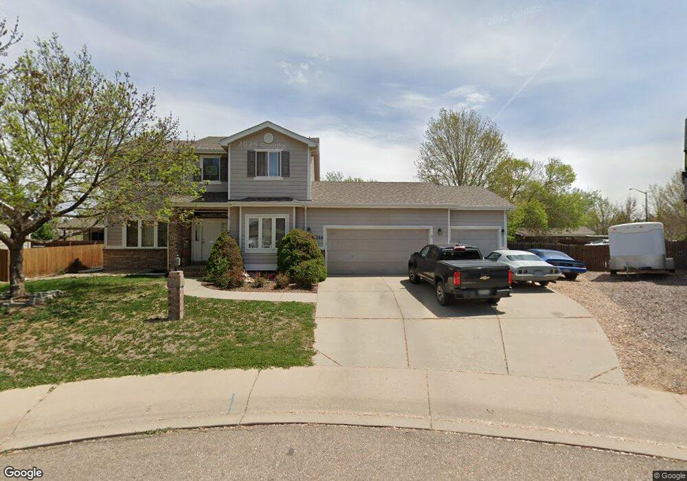
11284 Daisy Ct Firestone, CO 80504
Estimated Value: $505,000 - $530,831
3
Beds
3
Baths
1,831
Sq Ft
$284/Sq Ft
Est. Value
About This Home
This home is located at 11284 Daisy Ct, Firestone, CO 80504 and is currently estimated at $520,458, approximately $284 per square foot. 11284 Daisy Ct is a home located in Weld County with nearby schools including Prairie Ridge Elementary School, Coal Ridge Middle School, and Frederick Senior High School.
Ownership History
Date
Name
Owned For
Owner Type
Purchase Details
Closed on
Jun 28, 2002
Sold by
Country Meadow Homes Inc
Bought by
Johnson Dennis J and Johnson Pamela K
Current Estimated Value
Home Financials for this Owner
Home Financials are based on the most recent Mortgage that was taken out on this home.
Original Mortgage
$188,400
Outstanding Balance
$82,859
Interest Rate
7.24%
Estimated Equity
$437,599
Purchase Details
Closed on
Sep 11, 2001
Sold by
Bashor Brett
Bought by
Country Meadow Homes Inc
Create a Home Valuation Report for This Property
The Home Valuation Report is an in-depth analysis detailing your home's value as well as a comparison with similar homes in the area
Home Values in the Area
Average Home Value in this Area
Purchase History
| Date | Buyer | Sale Price | Title Company |
|---|---|---|---|
| Johnson Dennis J | $235,500 | -- | |
| Country Meadow Homes Inc | $50,000 | -- |
Source: Public Records
Mortgage History
| Date | Status | Borrower | Loan Amount |
|---|---|---|---|
| Open | Johnson Dennis J | $188,400 |
Source: Public Records
Tax History
| Year | Tax Paid | Tax Assessment Tax Assessment Total Assessment is a certain percentage of the fair market value that is determined by local assessors to be the total taxable value of land and additions on the property. | Land | Improvement |
|---|---|---|---|---|
| 2025 | $3,199 | $32,750 | $7,380 | $25,370 |
| 2024 | $3,199 | $32,750 | $7,380 | $25,370 |
| 2023 | $3,069 | $34,670 | $7,980 | $26,690 |
| 2022 | $2,732 | $26,120 | $5,210 | $20,910 |
| 2021 | $2,759 | $26,870 | $5,360 | $21,510 |
| 2020 | $2,628 | $25,800 | $4,290 | $21,510 |
| 2019 | $2,666 | $25,800 | $4,290 | $21,510 |
| 2018 | $2,341 | $23,510 | $4,320 | $19,190 |
| 2017 | $2,393 | $23,510 | $4,320 | $19,190 |
| 2016 | $2,192 | $21,190 | $4,460 | $16,730 |
| 2015 | $2,125 | $21,190 | $4,460 | $16,730 |
| 2014 | $1,561 | $15,580 | $1,910 | $13,670 |
Source: Public Records
Map
Nearby Homes
- 6188 Twilight Ave
- 5950 Twilight Ave
- 6348 Union Ave
- 6911 Utica Ave
- 11392 Ebony St
- 10818 Cimarron St Unit 1006
- 5965 Thistle Ridge Ave
- 6744 Utica Ave
- 6749 Utica Ave
- 6757 Utica Ave
- 6765 Utica Cir
- 6773 Utica Cir
- 6781 Utica Cir
- 6785 Utica Cir
- 6793 Utica Cir
- 6801 Utica Cir
- 10529 Taylor Ave
- 10516 Sunburst Ave
- 10548 Sunburst Ave
- 6718 Thistle Ridge Ave
- 11274 Daisy Ct
- 11275 Deerfield Dr
- 11297 Deerfield Dr
- 11263 Deerfield Dr
- 11294 Daisy Ct
- 6050 Valley Vista Ave
- 6064 Valley Vista Ave
- 11285 Daisy Ct
- 11297 Daisy Ct
- 6076 Valley Vista Ave
- 11275 Daisy Ct
- 11307 Daisy Ct
- 11288 Deerfield Dr
- 11274 Deerfield Dr
- 11319 Daisy Ct
- 11302 Deerfield Dr
- 11262 Deerfield Dr
- 11251 Deerfield Dr
- 6067 Ulysses Ave
- 6043 Ulysses Ave
Your Personal Tour Guide
Ask me questions while you tour the home.