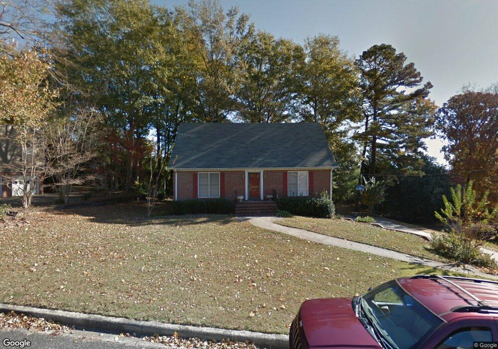
1129 Karl Daly Trace Irondale, AL 35210
Estimated Value: $302,000 - $378,000
4
Beds
3
Baths
2,236
Sq Ft
$155/Sq Ft
Est. Value
About This Home
This home is located at 1129 Karl Daly Trace, Irondale, AL 35210 and is currently estimated at $346,170, approximately $154 per square foot. 1129 Karl Daly Trace is a home located in Jefferson County with nearby schools including Grantswood Community Elementary School, Irondale Middle School, and Shades Valley High School.
Ownership History
Date
Name
Owned For
Owner Type
Purchase Details
Closed on
Oct 29, 2023
Sold by
Stroud Thomas P
Bought by
Alabama Power Co
Current Estimated Value
Purchase Details
Closed on
Aug 8, 2016
Sold by
Stroud Vanessa N
Bought by
Stroud Thomas P
Home Financials for this Owner
Home Financials are based on the most recent Mortgage that was taken out on this home.
Original Mortgage
$152,800
Interest Rate
3.41%
Mortgage Type
New Conventional
Purchase Details
Closed on
Mar 29, 1999
Sold by
Croce Faye W
Bought by
Stroud Thomas P and Stroud Vanessa N
Home Financials for this Owner
Home Financials are based on the most recent Mortgage that was taken out on this home.
Original Mortgage
$142,405
Interest Rate
6.82%
Create a Home Valuation Report for This Property
The Home Valuation Report is an in-depth analysis detailing your home's value as well as a comparison with similar homes in the area
Home Values in the Area
Average Home Value in this Area
Purchase History
| Date | Buyer | Sale Price | Title Company |
|---|---|---|---|
| Alabama Power Co | -- | -- | |
| Stroud Thomas P | $500 | -- | |
| Stroud Thomas P | $149,900 | Alabama Title Co Inc |
Source: Public Records
Mortgage History
| Date | Status | Borrower | Loan Amount |
|---|---|---|---|
| Previous Owner | Stroud Thomas P | $152,800 | |
| Previous Owner | Stroud Thomas P | $142,405 |
Source: Public Records
Tax History Compared to Growth
Tax History
| Year | Tax Paid | Tax Assessment Tax Assessment Total Assessment is a certain percentage of the fair market value that is determined by local assessors to be the total taxable value of land and additions on the property. | Land | Improvement |
|---|---|---|---|---|
| 2024 | $1,734 | $28,540 | -- | -- |
| 2022 | $1,228 | $22,640 | $6,000 | $16,640 |
| 2021 | $1,099 | $20,350 | $6,000 | $14,350 |
| 2020 | $1,099 | $20,350 | $6,000 | $14,350 |
| 2019 | $1,099 | $20,360 | $0 | $0 |
| 2018 | $982 | $18,280 | $0 | $0 |
| 2017 | $982 | $18,280 | $0 | $0 |
| 2016 | $999 | $18,580 | $0 | $0 |
| 2015 | $982 | $18,280 | $0 | $0 |
| 2014 | $970 | $18,000 | $0 | $0 |
| 2013 | $970 | $17,980 | $0 | $0 |
Source: Public Records
Map
Nearby Homes
- 1119 Saddlebrook Rd
- 3287 Hoot Owl Ln
- 3265 Hoot Owl Ln Unit 1
- 3401 Batavia Ave
- 3408 Rock Ridge Cir
- 3290 Sunniroc Rd
- 3921 Rock Ridge Rd
- 3932 Rock Ridge Rd
- 3873 Rock Ridge Ct
- 1551 Hamby Ave
- 5363 Heritage Ln
- 1338 Creekside Glen
- 3913 Graham Dr
- 3940 Graham Dr
- 1800 Dorroh Rd
- 1236 Grants Mill Rd Unit 14 & 15
- 1233 Mill Ln
- 3520 Ridgeview Dr
- 3779 Maggies Dr
- 3778 Maggies Dr
- 1125 Karl Daly Trace
- 1133 Karl Daly Trace
- 1126 Karl Daly Trace
- 1130 Karl Daly Trace
- 1121 Karl Daly Trace
- 1122 Karl Daly Trace
- 1137 Karl Daly Trace
- 1137 Karl Daly Trc
- 928 Ivawood Rd
- 1117 Karl Daly Trace
- 1117 Karl Daly Trc
- 1134 Karl Daly Trace
- 3220 Brookhill Cir
- 1118 Karl Daly Trace
- 1138 Karl Daly Trace
- 3216 Brookhill Cir
- 3320 Saddlebrook Cir
- 3321 Saddlebrook Cir
- 3213 Brookhill Cir
- 1114 Karl Daly Trace