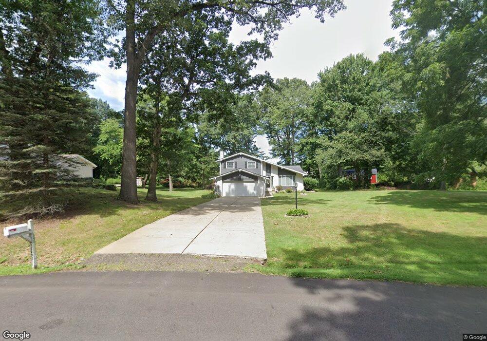
11291 Bridle Ave NE Uniontown, OH 44685
Estimated Value: $256,000 - $286,000
3
Beds
2
Baths
1,100
Sq Ft
$246/Sq Ft
Est. Value
About This Home
This home is located at 11291 Bridle Ave NE, Uniontown, OH 44685 and is currently estimated at $270,552, approximately $245 per square foot. 11291 Bridle Ave NE is a home located in Stark County with nearby schools including Lake Middle/High School and Lake Center Christian School.
Ownership History
Date
Name
Owned For
Owner Type
Purchase Details
Closed on
Oct 25, 1996
Sold by
Climes Thomas E
Bought by
Madden Anthony L
Current Estimated Value
Home Financials for this Owner
Home Financials are based on the most recent Mortgage that was taken out on this home.
Original Mortgage
$88,000
Interest Rate
8.32%
Mortgage Type
Balloon
Purchase Details
Closed on
Jun 9, 1993
Purchase Details
Closed on
Jul 13, 1990
Create a Home Valuation Report for This Property
The Home Valuation Report is an in-depth analysis detailing your home's value as well as a comparison with similar homes in the area
Home Values in the Area
Average Home Value in this Area
Purchase History
| Date | Buyer | Sale Price | Title Company |
|---|---|---|---|
| Madden Anthony L | $110,000 | -- | |
| -- | $95,000 | -- | |
| -- | $82,900 | -- |
Source: Public Records
Mortgage History
| Date | Status | Borrower | Loan Amount |
|---|---|---|---|
| Closed | Madden Anthony L | $88,000 |
Source: Public Records
Tax History Compared to Growth
Tax History
| Year | Tax Paid | Tax Assessment Tax Assessment Total Assessment is a certain percentage of the fair market value that is determined by local assessors to be the total taxable value of land and additions on the property. | Land | Improvement |
|---|---|---|---|---|
| 2025 | -- | $78,330 | $28,700 | $49,630 |
| 2024 | -- | $78,330 | $28,700 | $49,630 |
| 2023 | $2,979 | $63,840 | $17,920 | $45,920 |
| 2022 | $2,988 | $63,840 | $17,920 | $45,920 |
| 2021 | $3,023 | $63,840 | $17,920 | $45,920 |
| 2020 | $2,950 | $55,870 | $15,440 | $40,430 |
| 2019 | $2,923 | $55,870 | $15,440 | $40,430 |
| 2018 | $2,924 | $55,870 | $15,440 | $40,430 |
| 2017 | $2,730 | $48,450 | $15,440 | $33,010 |
| 2016 | $2,734 | $48,450 | $15,440 | $33,010 |
| 2015 | $2,732 | $48,450 | $15,440 | $33,010 |
| 2014 | $354 | $43,440 | $13,860 | $29,580 |
| 2013 | $1,177 | $43,440 | $13,860 | $29,580 |
Source: Public Records
Map
Nearby Homes
- 1037 Canyon St NE
- 747 Grandview Cir
- 786 Fair Vista Cir SW
- 778 Fair Vista Cir SW
- 531 Gentlebrook Blvd SW
- 550 Woodlands Glen Ave
- 525 Gentlebrook Blvd SW
- 11121 Geib Ave NE
- 2084 Hazel St NE
- 11900 Geib Ave NE
- 425 Tonawanda Trail SW
- 510 Meadow Cir SW Unit 11
- 12055 King Church Ave NW
- 225 Seneca Trail SW
- Unit 9 Meadow Trail SW Unit 9
- 1180 Tessa Trail Unit 1180
- 12201 King Church Ave NW
- 1975 Eloise Cir NE
- 1771 Midway St NW
- 330 Belle Ave SW
- 11269 Bridle Ave NE
- 11307 Bridle Ave NE
- 1188 Tumbleweed St NE
- 1210 Tumbleweed St NE
- 1170 Tumbleweed St NE
- 11290 Bridle Ave NE
- 11268 Bridle Ave NE
- 11325 Bridle Ave NE
- 1320 Saddle St NE
- 1270 Saddle St NE
- 11231 Bridle Ave NE
- 1226 Tumbleweed St NE
- 1150 Tumbleweed St NE
- 11250 Market Ave NE
- 1167 Tumbleweed St NE
- 1338 Saddle St NE
- 1185 Tumbleweed St NE
- 1185 Tumbleweed St NE
- 1130 Tumbleweed St NE
- 1233 Canyon St NE