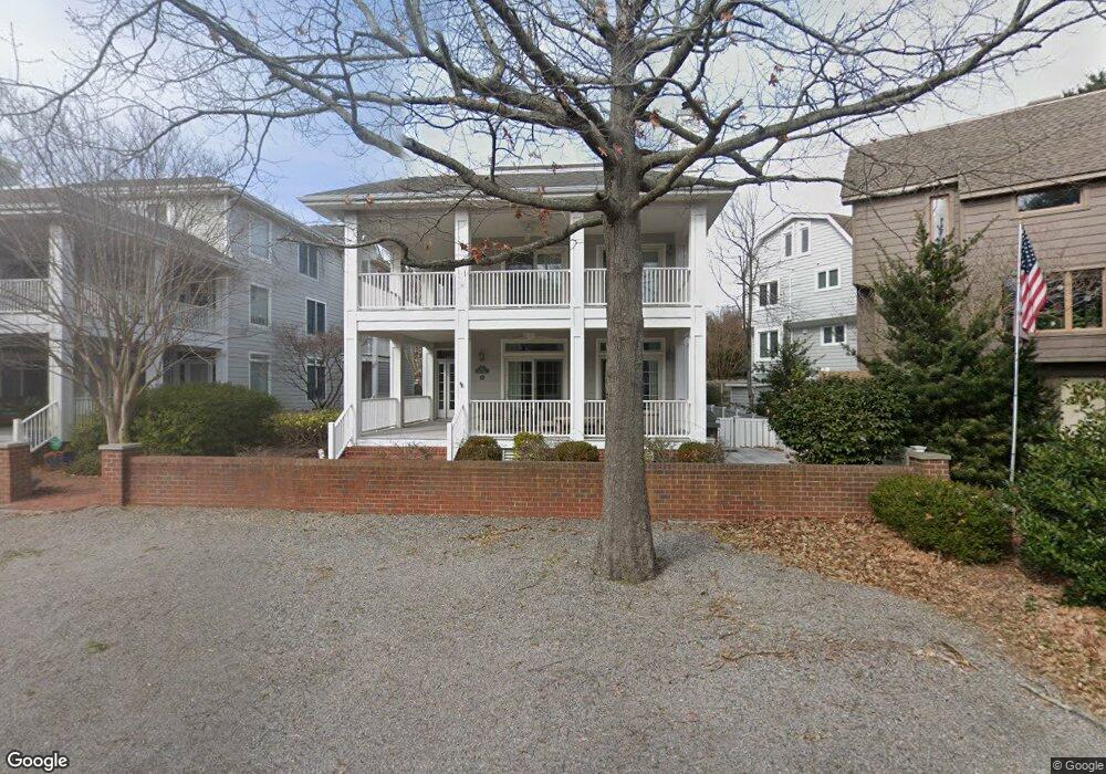
113 52nd St Unit A Virginia Beach, VA 23451
North End NeighborhoodEstimated Value: $1,387,000 - $1,640,000
4
Beds
4
Baths
2,750
Sq Ft
$548/Sq Ft
Est. Value
About This Home
This home is located at 113 52nd St Unit A, Virginia Beach, VA 23451 and is currently estimated at $1,508,040, approximately $548 per square foot. 113 52nd St Unit A is a home located in Virginia Beach City with nearby schools including Linkhorn Park Elementary School, Virginia Beach Middle School, and Frank W. Cox High School.
Ownership History
Date
Name
Owned For
Owner Type
Purchase Details
Closed on
May 18, 2011
Sold by
Maclachlan David A
Bought by
Cox Thomas K
Current Estimated Value
Home Financials for this Owner
Home Financials are based on the most recent Mortgage that was taken out on this home.
Original Mortgage
$458,850
Outstanding Balance
$319,759
Interest Rate
4.94%
Mortgage Type
New Conventional
Estimated Equity
$1,188,281
Create a Home Valuation Report for This Property
The Home Valuation Report is an in-depth analysis detailing your home's value as well as a comparison with similar homes in the area
Home Values in the Area
Average Home Value in this Area
Purchase History
| Date | Buyer | Sale Price | Title Company |
|---|---|---|---|
| Cox Thomas K | $942,500 | -- |
Source: Public Records
Mortgage History
| Date | Status | Borrower | Loan Amount |
|---|---|---|---|
| Open | Cox Thomas K | $458,850 |
Source: Public Records
Tax History Compared to Growth
Tax History
| Year | Tax Paid | Tax Assessment Tax Assessment Total Assessment is a certain percentage of the fair market value that is determined by local assessors to be the total taxable value of land and additions on the property. | Land | Improvement |
|---|---|---|---|---|
| 2025 | $10,793 | $1,218,600 | $805,000 | $413,600 |
| 2024 | $10,793 | $1,112,700 | $733,500 | $379,200 |
| 2023 | $10,062 | $1,016,400 | $666,400 | $350,000 |
| 2022 | $9,231 | $932,400 | $541,100 | $391,300 |
| 2021 | $8,360 | $844,400 | $491,900 | $352,500 |
| 2020 | $8,228 | $808,600 | $491,900 | $316,700 |
| 2019 | $8,068 | $719,000 | $384,500 | $334,500 |
| 2018 | $7,208 | $719,000 | $384,500 | $334,500 |
| 2017 | $7,688 | $766,900 | $424,800 | $342,100 |
| 2016 | $7,592 | $766,900 | $424,800 | $342,100 |
| 2015 | $6,807 | $687,600 | $402,500 | $285,100 |
| 2014 | $5,999 | $645,000 | $402,500 | $242,500 |
Source: Public Records
Map
Nearby Homes
- 206 50th St Unit C
- 210 56th St
- 302 55th St Unit B
- 216 56th St Unit A
- 5604 Holly Rd Unit B
- 300 Bay Colony Dr
- 112 60th St Unit B
- 400 Discovery Rd
- 436 Gosnold Ct
- 506 Cavalier Dr
- 219 64th St
- 209 Glenn Miller St
- 4004 Atlantic Ave Unit 707
- 4004 Atlantic Ave Unit 1710
- 4004 Atlantic Ave Unit 1911
- 4004 Atlantic Ave Unit 1004
- 4004 Atlantic Ave Unit 404
- 4004 Atlantic Ave Unit PH3
- 228 66th St
- 1116 Rose Ln
- 113 52nd St Unit B
- 113 52nd St Unit A
- 111 52nd St Unit B
- 111 52nd St Unit A
- 115A 52nd St
- 115 52nd St Unit A
- 115 52nd St Unit B
- 117 52nd St Unit B
- 109 52nd St Unit A
- 109 52nd St Unit B
- 112 53rd St
- 112 52nd St
- 114 53rd St Unit X1364
- 114 53rd St Unit X1630
- 114 53rd St
- 114 53rd St Unit A
- 114 53rd St Unit 114A
- 114 52nd St
- 107 52nd St Unit B
- 107 52nd St Unit A