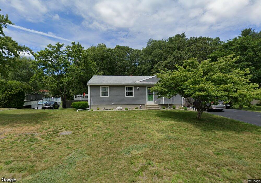
113 Briggs Rd Westport, MA 02790
North Westport NeighborhoodEstimated Value: $445,000 - $533,000
3
Beds
--
Bath
960
Sq Ft
$497/Sq Ft
Est. Value
About This Home
This home is located at 113 Briggs Rd, Westport, MA 02790 and is currently estimated at $476,911, approximately $496 per square foot. 113 Briggs Rd is a home located in Bristol County with nearby schools including Alice A. Macomber Primary School, Westport Elementary School, and Espirito Santo Parochial School.
Ownership History
Date
Name
Owned For
Owner Type
Purchase Details
Closed on
Jul 2, 2003
Sold by
Richard Arthur and Richard Carol
Bought by
Richard Arthur
Current Estimated Value
Purchase Details
Closed on
Apr 6, 1976
Bought by
Richard Arthur and Richard Eric
Create a Home Valuation Report for This Property
The Home Valuation Report is an in-depth analysis detailing your home's value as well as a comparison with similar homes in the area
Home Values in the Area
Average Home Value in this Area
Purchase History
| Date | Buyer | Sale Price | Title Company |
|---|---|---|---|
| Richard Arthur | -- | -- | |
| Richard Arthur | -- | -- |
Source: Public Records
Mortgage History
| Date | Status | Borrower | Loan Amount |
|---|---|---|---|
| Open | Richard Arthur | $25,000 | |
| Open | Richard Arthur | $125,000 | |
| Closed | Richard Arthur | $20,000 |
Source: Public Records
Tax History Compared to Growth
Tax History
| Year | Tax Paid | Tax Assessment Tax Assessment Total Assessment is a certain percentage of the fair market value that is determined by local assessors to be the total taxable value of land and additions on the property. | Land | Improvement |
|---|---|---|---|---|
| 2025 | $3,002 | $403,000 | $168,800 | $234,200 |
| 2024 | $2,945 | $381,000 | $149,900 | $231,100 |
| 2023 | $2,811 | $344,500 | $136,600 | $207,900 |
| 2022 | $1,970 | $252,200 | $136,600 | $115,600 |
| 2021 | $1,970 | $228,500 | $112,900 | $115,600 |
| 2020 | $1,888 | $224,000 | $108,400 | $115,600 |
| 2019 | $1,848 | $223,500 | $108,400 | $115,100 |
| 2018 | $1,788 | $218,800 | $116,600 | $102,200 |
| 2017 | $1,728 | $216,800 | $116,600 | $100,200 |
| 2016 | $1,641 | $207,500 | $116,600 | $90,900 |
| 2015 | $1,568 | $197,700 | $116,600 | $81,100 |
Source: Public Records
Map
Nearby Homes
- 109 Briggs Rd
- 105 Briggs Rd
- 119 Briggs Rd
- 110 Briggs Rd
- 108 Briggs Rd
- 101 Briggs Rd
- 116 Briggs Rd
- 104 Briggs Rd
- 123 Briggs Rd Unit 125
- 31 Madison Ct
- 3 Heritage Dr
- 95 Briggs Rd
- 95 Briggs Rd Unit 2
- 32 Madison Ct
- 131 Briggs Rd Unit 133
- 128 Briggs Rd
- 26 Madison Ct
- 15 Madison Ct
- 8 Heritage Dr
- 132 Briggs Rd