Estimated Value: $805,000 - $1,084,121
5
Beds
4
Baths
2,494
Sq Ft
$363/Sq Ft
Est. Value
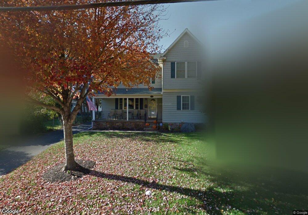
About This Home
This home is located at 113 Lantoga Rd, Wayne, PA 19087 and is currently estimated at $906,030, approximately $363 per square foot. 113 Lantoga Rd is a home located in Delaware County with nearby schools including Wayne Elementary School, Radnor Middle School, and Radnor Senior High School.
Ownership History
Date
Name
Owned For
Owner Type
Purchase Details
Closed on
May 21, 2007
Sold by
Estate Of Mary Louise Whitehead
Bought by
Whitehead Robert A and Whitehead Sara C
Current Estimated Value
Purchase Details
Closed on
Dec 8, 2003
Sold by
Taunton John Christopher and Taunton Rosemary
Bought by
Whitehead Kenneth and Whitehead Mary Louise
Purchase Details
Closed on
May 28, 2002
Sold by
Skatz Louis A and Estate Of Grace A Skatz
Bought by
Taunton John Christopher and Taunton Rosemary
Home Financials for this Owner
Home Financials are based on the most recent Mortgage that was taken out on this home.
Original Mortgage
$150,000
Interest Rate
6.9%
Mortgage Type
Purchase Money Mortgage
Create a Home Valuation Report for This Property
The Home Valuation Report is an in-depth analysis detailing your home's value as well as a comparison with similar homes in the area
Home Values in the Area
Average Home Value in this Area
Purchase History
| Date | Buyer | Sale Price | Title Company |
|---|---|---|---|
| Whitehead Robert A | -- | None Available | |
| Whitehead Kenneth | $332,000 | -- | |
| Taunton John Christopher | $285,000 | Fidelity National Title Ins |
Source: Public Records
Mortgage History
| Date | Status | Borrower | Loan Amount |
|---|---|---|---|
| Previous Owner | Taunton John Christopher | $150,000 |
Source: Public Records
Tax History
| Year | Tax Paid | Tax Assessment Tax Assessment Total Assessment is a certain percentage of the fair market value that is determined by local assessors to be the total taxable value of land and additions on the property. | Land | Improvement |
|---|---|---|---|---|
| 2025 | $13,069 | $646,380 | $134,610 | $511,770 |
| 2024 | $13,069 | $646,380 | $134,610 | $511,770 |
| 2023 | $12,551 | $646,380 | $134,610 | $511,770 |
| 2022 | $12,414 | $646,380 | $134,610 | $511,770 |
| 2021 | $19,940 | $646,380 | $134,610 | $511,770 |
| 2020 | $9,606 | $276,130 | $66,110 | $210,020 |
| 2019 | $9,335 | $276,130 | $66,110 | $210,020 |
| 2018 | $9,152 | $276,130 | $0 | $0 |
| 2017 | $8,960 | $276,130 | $0 | $0 |
| 2016 | $1,546 | $247,400 | $0 | $0 |
| 2015 | $1,385 | $247,400 | $0 | $0 |
| 2014 | $1,385 | $247,400 | $0 | $0 |
Source: Public Records
Map
Nearby Homes
- 412 Fairview Dr
- 301 Eagle Rd
- 203 Church St
- 116 Morningside Cir
- 443 Homestead Rd
- 120 Eaton Dr
- 658 Brooke Rd
- 155 Eaton Dr
- 211 Deepdale Rd
- 93 Hillside Rd
- 50 Fariston Rd
- 245 Willow Ave
- 205 N Aberdeen Ave
- 120 S Devon Ave
- 444 Saint Davids Ave
- 131 Sugartown Rd
- 1052 Eagle Rd
- 211 Bella Vista Rd
- 466 Saint Davids Ave
- 317 E Beechtree Ln
- 111 Lantoga Rd
- 159 Conestoga Rd
- 157 Conestoga Rd
- 109 Lantoga Rd
- 13-15 Doyle Rd
- 13 Doyle Rd
- 153 Conestoga Rd
- 155 Conestoga Rd
- 107 Lantoga Rd
- 11 Doyle Rd
- 110 Lantoga Rd Unit 1
- 105 Lantoga Rd
- 16 Doyle Rd
- 116 Lantoga Rd Unit 4
- 9 Doyle Rd
- 103 Lantoga Rd
- 108 Lantoga Rd
- 167 Conestoga Rd
- 12 Doyle Rd
- 169 Conestoga Rd
Your Personal Tour Guide
Ask me questions while you tour the home.