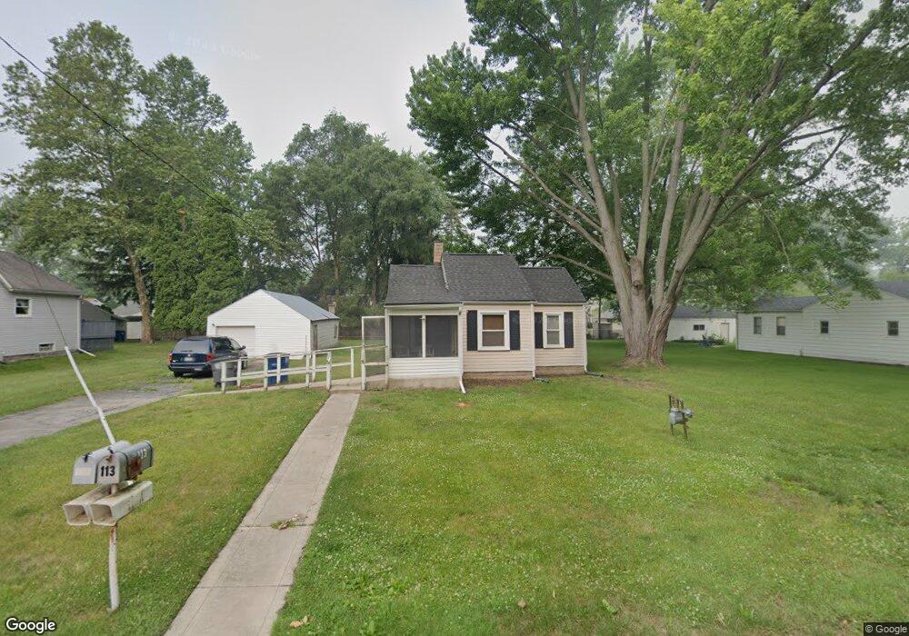
113 Leander Dr Toledo, OH 43615
Reynolds Corners NeighborhoodEstimated Value: $69,000 - $99,000
2
Beds
1
Bath
608
Sq Ft
$137/Sq Ft
Est. Value
About This Home
This home is located at 113 Leander Dr, Toledo, OH 43615 and is currently estimated at $83,172, approximately $136 per square foot. 113 Leander Dr is a home located in Lucas County with nearby schools including McTigue Elementary School, Rogers High School, and Horizon Science Academy-Springfield.
Ownership History
Date
Name
Owned For
Owner Type
Purchase Details
Closed on
Jul 5, 2024
Sold by
Simmons Susan and Mcdowell Karen
Bought by
Connerton Sandra
Current Estimated Value
Purchase Details
Closed on
Sep 6, 2016
Sold by
Connerton Sandra L
Bought by
Watkins Timothy J
Purchase Details
Closed on
Jul 27, 2015
Sold by
Watkins Timothy J
Bought by
Watkins Timothy J and Connerton Sandra L
Purchase Details
Closed on
Jul 23, 2012
Sold by
Smitley Mildred L and Weber Janet
Bought by
Watkins Timothy J
Purchase Details
Closed on
May 30, 2008
Sold by
Estate Of Arthur E Smitley
Bought by
Smitley Mildred L
Create a Home Valuation Report for This Property
The Home Valuation Report is an in-depth analysis detailing your home's value as well as a comparison with similar homes in the area
Home Values in the Area
Average Home Value in this Area
Purchase History
| Date | Buyer | Sale Price | Title Company |
|---|---|---|---|
| Connerton Sandra | $62,000 | None Listed On Document | |
| Watkins Timothy J | -- | None Available | |
| Watkins Timothy J | -- | None Available | |
| Watkins Timothy J | $6,250 | None Available | |
| Smitley Mildred L | -- | None Available |
Source: Public Records
Tax History
| Year | Tax Paid | Tax Assessment Tax Assessment Total Assessment is a certain percentage of the fair market value that is determined by local assessors to be the total taxable value of land and additions on the property. | Land | Improvement |
|---|---|---|---|---|
| 2025 | $1,857 | $23,555 | $4,830 | $18,725 |
| 2024 | $1,623 | $23,555 | $4,830 | $18,725 |
| 2023 | $1,417 | $21,420 | $5,740 | $15,680 |
| 2022 | $1,407 | $21,420 | $5,740 | $15,680 |
| 2021 | $1,455 | $21,420 | $5,740 | $15,680 |
| 2020 | $1,373 | $17,605 | $4,725 | $12,880 |
| 2019 | $1,357 | $17,605 | $4,725 | $12,880 |
| 2018 | $1,376 | $17,605 | $4,725 | $12,880 |
| 2017 | $3,593 | $17,220 | $4,620 | $12,600 |
| 2016 | $2,180 | $49,200 | $13,200 | $36,000 |
| 2015 | $1,391 | $49,200 | $13,200 | $36,000 |
| 2014 | $1,669 | $17,220 | $4,620 | $12,600 |
| 2013 | $1,113 | $17,220 | $4,620 | $12,600 |
Source: Public Records
Map
Nearby Homes
- 216 Deigle Dr
- 6324 Bapst Ave
- 30 N Favony Ave
- 127 N Dorcas Rd
- 630 Saturn Dr
- 419 N Holland Sylvania Rd
- 605 Koch Dr
- 5845 Cook Dr
- 8161 Hill Ave
- 6032 Willowvale Dr
- 549 Dorcas Rd
- 47 Medbury St
- 148 Curwood Rd
- 607 S Mccord Rd
- 128 Pebble Beach Dr
- 136 Pebble Beach Dr
- 1137 Bedford Woods Dr
- 622 Meadowland Trail
- 1207 Vanderbilt Rd
- 1809 Birdie Dr
Your Personal Tour Guide
Ask me questions while you tour the home.