
Seller's Agent in 2013
Linda Turpin
Re/Max Of Albany
(229) 881-1529
99 Total Sales

Estimated Value: $101,000 - $171,596
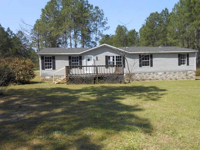
Country living in Worth County. 3 bedroom 2 bath with 1540 sq feet. Great starter home or retirement spot. Open floor plan with large kitchen. Large backyard. Permanent Foundation. Call your REALTOR today. Potential purchasers go to www.hometelosfirst.com for more information on specific subjects. .NEW BROKER BONUS-Property eligible for Selling Agent Broker Bonus for bids submitted on or after December 1, 2011. Eligibility for the bonus requires that the case close: Before day 34 100% $600 Days 35 to 39 75% $450 Days 40 to 43 50% $300
Last Agent to Sell the Property
Re/Max Of Albany Brokerage Phone: 2294341600 License #162005 Listed on: 06/06/2013
| Date | Buyer | Sale Price | Title Company |
|---|---|---|---|
| Lee Melvin Houston | -- | -- | |
| Dailey Robert L | $19,000 | -- | |
| Sec Of Housing & Urban | $103,522 | -- | |
| Bank Of America | $103,522 | -- | |
| Trawick Rondell L | $15,000 | -- |
| Date | Status | Borrower | Loan Amount |
|---|---|---|---|
| Previous Owner | Dailey Robert L | $19,000 |
| Date | Event | Price | List to Sale | Price per Sq Ft |
|---|---|---|---|---|
| 07/12/2013 07/12/13 | Sold | $19,000 | -- | $12 / Sq Ft |
| 06/06/2013 06/06/13 | Pending | -- | -- | -- |
| Year | Tax Paid | Tax Assessment Tax Assessment Total Assessment is a certain percentage of the fair market value that is determined by local assessors to be the total taxable value of land and additions on the property. | Land | Improvement |
|---|---|---|---|---|
| 2025 | -- | $45,950 | $6,000 | $39,950 |
| 2024 | -- | $37,793 | $6,000 | $31,793 |
| 2023 | $0 | $37,793 | $6,000 | $31,793 |
| 2022 | $1,175 | $33,900 | $6,000 | $27,900 |
| 2021 | $1,175 | $33,900 | $6,000 | $27,900 |
| 2020 | $1,175 | $33,900 | $6,000 | $27,900 |
| 2019 | $1,175 | $33,900 | $6,000 | $27,900 |
| 2018 | $1,175 | $33,900 | $6,000 | $27,900 |
| 2017 | $1,175 | $33,900 | $6,000 | $27,900 |
| 2016 | -- | $33,900 | $6,000 | $27,900 |
| 2015 | $1,120 | $33,900 | $6,000 | $27,900 |
| 2014 | $1,176 | $33,900 | $6,000 | $27,900 |
| 2013 | -- | $33,900 | $6,000 | $27,900 |
| 2012 | -- | $6,000 | $6,000 | $0 |
Seller's Agent in 2013
Linda Turpin
Re/Max Of Albany
(229) 881-1529
99 Total Sales
Seller Co-Listing Agent in 2013
Vickie Giles-Griffin
Re/Max Of Albany
100 Total Sales
J
Buyer's Agent in 2013
Janice Smith
Janice Smith Realty, LLC
(229) 336-5884
23 Total Sales
Source: Albany Board of REALTORS®
MLS Number: 128649
APN: 0090A-074-000
Ask me questions while you tour the home.