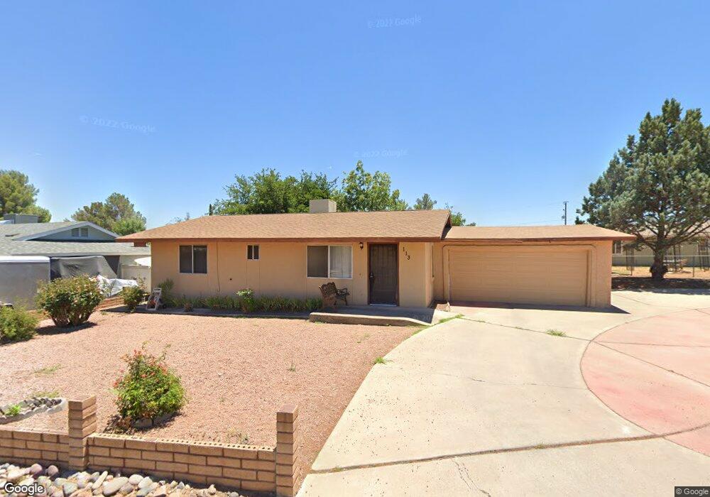
113 N Palo Verde St Cottonwood, AZ 86326
Cottonwood NeighborhoodEstimated Value: $299,000 - $365,000
--
Bed
--
Bath
1,064
Sq Ft
$312/Sq Ft
Est. Value
About This Home
This home is located at 113 N Palo Verde St, Cottonwood, AZ 86326 and is currently estimated at $332,299, approximately $312 per square foot. 113 N Palo Verde St is a home located in Yavapai County with nearby schools including Cottonwood Elementary School, Dr Daniel Bright Elementary School, and Cottonwood Community School.
Ownership History
Date
Name
Owned For
Owner Type
Purchase Details
Closed on
Aug 20, 2001
Sold by
Ward Frances L
Bought by
Ward Frances Louise and Frances Ward Living Trust
Current Estimated Value
Purchase Details
Closed on
Nov 6, 1995
Sold by
Lukasik Walter and Lukasik Jean M
Bought by
Ward Frances L
Home Financials for this Owner
Home Financials are based on the most recent Mortgage that was taken out on this home.
Original Mortgage
$67,500
Outstanding Balance
$932
Interest Rate
7.47%
Mortgage Type
Assumption
Estimated Equity
$331,367
Create a Home Valuation Report for This Property
The Home Valuation Report is an in-depth analysis detailing your home's value as well as a comparison with similar homes in the area
Home Values in the Area
Average Home Value in this Area
Purchase History
| Date | Buyer | Sale Price | Title Company |
|---|---|---|---|
| Ward Frances Louise | -- | -- | |
| Ward Frances L | $77,500 | Capital Title Agency |
Source: Public Records
Mortgage History
| Date | Status | Borrower | Loan Amount |
|---|---|---|---|
| Open | Ward Frances L | $67,500 |
Source: Public Records
Tax History Compared to Growth
Tax History
| Year | Tax Paid | Tax Assessment Tax Assessment Total Assessment is a certain percentage of the fair market value that is determined by local assessors to be the total taxable value of land and additions on the property. | Land | Improvement |
|---|---|---|---|---|
| 2026 | $681 | $23,934 | -- | -- |
| 2024 | $667 | $23,129 | -- | -- |
| 2023 | $667 | $17,228 | $4,717 | $12,511 |
| 2022 | $665 | $14,647 | $3,603 | $11,044 |
| 2021 | $723 | $12,385 | $2,404 | $9,981 |
| 2020 | $718 | $0 | $0 | $0 |
| 2019 | $714 | $0 | $0 | $0 |
| 2018 | $686 | $0 | $0 | $0 |
| 2017 | $657 | $0 | $0 | $0 |
| 2016 | $646 | $0 | $0 | $0 |
| 2015 | $647 | $0 | $0 | $0 |
| 2014 | $573 | $0 | $0 | $0 |
Source: Public Records
Map
Nearby Homes
- 15 N Alamos Dr Unit A & B
- 199 S Candy Ln
- 501 Kindra Heights Rd
- 258 Justin Dr
- 775 N Verde Heights Dr
- 490 Kindra Heights Rd
- 488 Kindra Heights Rd
- Xxxx Xxxx --
- 565 N Willard Dr
- 270 Ironwood St
- 217 W Pinal St
- 325 W State Route 89a Unit 7
- 325 W State Route 89a -- Unit 16
- 325 W State Route 89a -- Unit 65
- 325 W State Route 89a -- Unit 73
- 325 W State Route 89a -- Unit 15
- 240 S Maverick Way
- 1008 N Main St
- 981 W On the Greens Blvd
- 107 E Pinal St