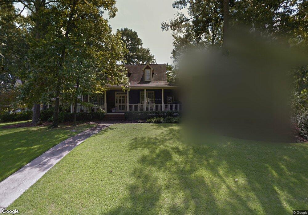
113 Rook Branch Ln Columbia, SC 29209
The Hamptons NeighborhoodEstimated Value: $465,000 - $512,000
3
Beds
3
Baths
2,325
Sq Ft
$208/Sq Ft
Est. Value
About This Home
This home is located at 113 Rook Branch Ln, Columbia, SC 29209 and is currently estimated at $482,640, approximately $207 per square foot. 113 Rook Branch Ln is a home located in Richland County with nearby schools including Meadowfield Elementary School, Hand Middle School, and Dreher High School.
Ownership History
Date
Name
Owned For
Owner Type
Purchase Details
Closed on
May 28, 2020
Sold by
Davis Gary A and Davis Kelly J
Bought by
Rainsford Matthew Stevens and Rainsford Kelly Hunter
Current Estimated Value
Home Financials for this Owner
Home Financials are based on the most recent Mortgage that was taken out on this home.
Original Mortgage
$296,100
Outstanding Balance
$262,470
Interest Rate
3.2%
Mortgage Type
New Conventional
Estimated Equity
$220,170
Create a Home Valuation Report for This Property
The Home Valuation Report is an in-depth analysis detailing your home's value as well as a comparison with similar homes in the area
Home Values in the Area
Average Home Value in this Area
Purchase History
| Date | Buyer | Sale Price | Title Company |
|---|---|---|---|
| Rainsford Matthew Stevens | $329,000 | None Available |
Source: Public Records
Mortgage History
| Date | Status | Borrower | Loan Amount |
|---|---|---|---|
| Open | Rainsford Matthew Stevens | $296,100 |
Source: Public Records
Tax History Compared to Growth
Tax History
| Year | Tax Paid | Tax Assessment Tax Assessment Total Assessment is a certain percentage of the fair market value that is determined by local assessors to be the total taxable value of land and additions on the property. | Land | Improvement |
|---|---|---|---|---|
| 2024 | $2,772 | $378,400 | $0 | $0 |
| 2023 | $2,772 | $13,160 | $0 | $0 |
| 2022 | $2,514 | $329,000 | $47,700 | $281,300 |
| 2021 | $2,552 | $13,160 | $0 | $0 |
| 2020 | $2,245 | $11,100 | $0 | $0 |
| 2019 | $2,234 | $11,100 | $0 | $0 |
| 2018 | $1,984 | $9,650 | $0 | $0 |
| 2017 | $1,936 | $9,650 | $0 | $0 |
| 2016 | $1,927 | $9,650 | $0 | $0 |
| 2015 | $1,868 | $9,650 | $0 | $0 |
| 2014 | $1,806 | $241,300 | $0 | $0 |
| 2013 | -- | $9,650 | $0 | $0 |
Source: Public Records
Map
Nearby Homes
- 604 Hampton Trace Ln
- 622 Chimney Hill Rd
- 109 Rosebank Dr
- 1825 Tall Pines Cir
- 1801 Tall Pines Cir
- 1769 Tall Pines Cir
- 1511 Tall Pines Cir
- 1637 Tall Pines Cir
- 6400 Saye Cut
- 1634 S Beltline Blvd
- 1557 S Beltline Blvd
- 1126 S Beltline Blvd
- 6603 Christie Rd
- 1425 Laburnum Dr
- 6627 Christie Rd
- 3910 Edmond Dr
- 104 Preserve Ln
- 1430 Dahlia Rd
- 405 Black Friars Rd
- 1215 Chevis St
- 109 Rook Branch Ln
- 37 Oak Hollow Ct
- 1 Oak Hollow Ct
- 112 Rook Branch Ln
- 108 Rook Branch Ln
- 5 Oak Hollow Ct
- 104 Rook Branch Ln
- 116 Rook Branch Ln
- 33 Oak Hollow Ct
- 9 Oak Hollow Ct
- 513 Hampton Trace Ln
- 125 Rook Branch Ln
- 517 Hampton Trace Ln
- 29 Oak Hollow Ct
- 13 Oak Hollow Ct
- 625 Hampton Trace Ln
- 629 Hampton Trace Ln
- 633 Hampton Trace Ln
- 509 Hampton Trace Ln
- 124 Rook Branch Ln