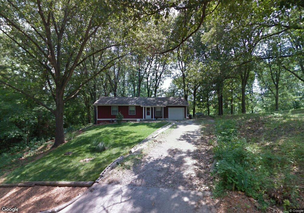
113 Rosedale St Cassville, MO 65625
Estimated Value: $166,000 - $184,000
3
Beds
2
Baths
1,334
Sq Ft
$133/Sq Ft
Est. Value
About This Home
This home is located at 113 Rosedale St, Cassville, MO 65625 and is currently estimated at $177,333, approximately $132 per square foot. 113 Rosedale St is a home located in Barry County with nearby schools including Eunice Thomas Elementary School, Cassville Intermediate School, and Cassville Middle School.
Ownership History
Date
Name
Owned For
Owner Type
Purchase Details
Closed on
Sep 22, 2009
Sold by
Mcgruder Demetria
Bought by
Robbins Michael R and Robbins Bre Nne
Current Estimated Value
Home Financials for this Owner
Home Financials are based on the most recent Mortgage that was taken out on this home.
Original Mortgage
$85,200
Outstanding Balance
$55,522
Interest Rate
5.12%
Mortgage Type
New Conventional
Estimated Equity
$121,811
Purchase Details
Closed on
Oct 20, 2005
Sold by
Moore Marsha Ann
Bought by
Coupland Kenny W and Flynn Brandi
Home Financials for this Owner
Home Financials are based on the most recent Mortgage that was taken out on this home.
Original Mortgage
$80,988
Interest Rate
5.69%
Mortgage Type
New Conventional
Create a Home Valuation Report for This Property
The Home Valuation Report is an in-depth analysis detailing your home's value as well as a comparison with similar homes in the area
Home Values in the Area
Average Home Value in this Area
Purchase History
| Date | Buyer | Sale Price | Title Company |
|---|---|---|---|
| Robbins Michael R | -- | None Available | |
| Coupland Kenny W | -- | Security Abstract & Title |
Source: Public Records
Mortgage History
| Date | Status | Borrower | Loan Amount |
|---|---|---|---|
| Open | Robbins Michael R | $85,200 | |
| Previous Owner | Coupland Kenny W | $80,988 |
Source: Public Records
Tax History Compared to Growth
Tax History
| Year | Tax Paid | Tax Assessment Tax Assessment Total Assessment is a certain percentage of the fair market value that is determined by local assessors to be the total taxable value of land and additions on the property. | Land | Improvement |
|---|---|---|---|---|
| 2025 | $59 | $14,003 | $2,090 | $11,913 |
| 2024 | $590 | $12,920 | $2,090 | $10,830 |
| 2023 | $589 | $12,920 | $2,090 | $10,830 |
| 2022 | $568 | $12,445 | $1,615 | $10,830 |
| 2021 | $570 | $12,445 | $1,615 | $10,830 |
| 2020 | $570 | $12,445 | $1,615 | $10,830 |
| 2018 | $557 | $12,445 | $1,615 | $10,830 |
| 2017 | $556 | $12,445 | $1,615 | $10,830 |
| 2016 | $516 | $11,419 | $1,387 | $10,032 |
| 2015 | -- | $11,419 | $1,387 | $10,032 |
| 2014 | -- | $11,381 | $1,387 | $9,994 |
| 2012 | -- | $0 | $0 | $0 |
Source: Public Records
Map
Nearby Homes
- 1421 Oakhill Dr
- 000 Luney Dr
- 303 Melton Way
- 3110 Main St
- 1408 Nottingham Dr
- 129 Robinhood Dr
- 1605 N Main St
- 1103 Townsend St
- 000 Townsend West 9th
- 1112 Harold St
- 106 Mountain St
- 000 State Highway 86
- Tbd State Highway 76
- 75 Sycamore Dr
- 34 Sunset St
- 83 Main St
- 1400 Old Exeter Rd
- Lot 4 State Highway 112
- Lot 2 State Highway 112
- Lot 3 State Highway 112
- 111 Rosedale St
- 1843 County Farm Rd
- 110 Rosedale St
- 109 Rosedale St
- 1845 County Farm Rd
- 307 Valley St
- 517 Valley Dr
- 517 Valley St
- 106 Rosedale St
- 114 Laray St
- 105 Rosedale St
- 103 Keith St
- 1305 County Farm Rd
- 000 County Farm Rd
- 808 Edison Rd
- 104 Rosedale St
- 1426 Oakhill Dr
- 1428 Oakhill Dr
- 502 Valley St
- Tbd County Farm Rd