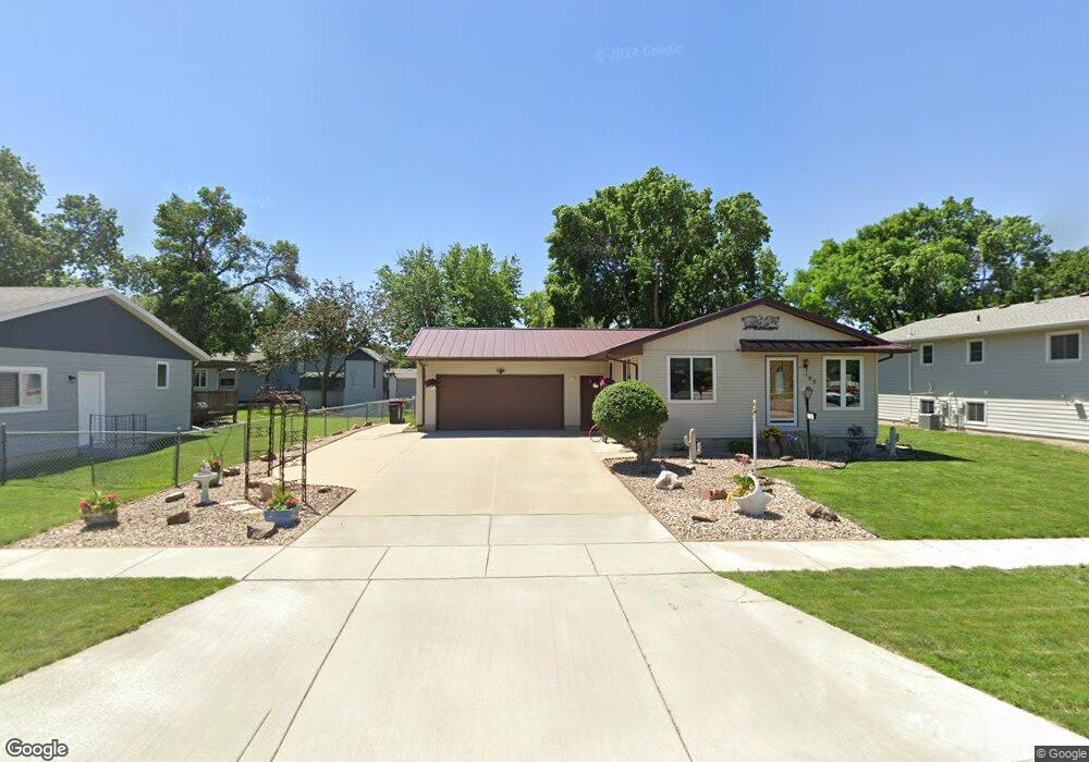
113 W Fir St Brandon, SD 57005
Estimated Value: $347,618 - $379,000
4
Beds
3
Baths
1,088
Sq Ft
$332/Sq Ft
Est. Value
About This Home
This home is located at 113 W Fir St, Brandon, SD 57005 and is currently estimated at $361,655, approximately $332 per square foot. 113 W Fir St is a home located in Minnehaha County with nearby schools including Robert Bennis Elementary School, Brandon Valley Middle School, and Brandon Valley Intermediate School.
Ownership History
Date
Name
Owned For
Owner Type
Purchase Details
Closed on
Nov 21, 2018
Sold by
Walkes Dominic J and Walkes Hannah
Bought by
Boushee Abe J
Current Estimated Value
Home Financials for this Owner
Home Financials are based on the most recent Mortgage that was taken out on this home.
Original Mortgage
$221,906
Outstanding Balance
$195,122
Interest Rate
4.8%
Mortgage Type
Stand Alone First
Estimated Equity
$166,533
Create a Home Valuation Report for This Property
The Home Valuation Report is an in-depth analysis detailing your home's value as well as a comparison with similar homes in the area
Home Values in the Area
Average Home Value in this Area
Purchase History
| Date | Buyer | Sale Price | Title Company |
|---|---|---|---|
| Boushee Abe J | $226,000 | Stewart Title Company |
Source: Public Records
Mortgage History
| Date | Status | Borrower | Loan Amount |
|---|---|---|---|
| Open | Boushee Abe J | $221,906 | |
| Closed | Boushee Abe J | $221,906 |
Source: Public Records
Tax History Compared to Growth
Tax History
| Year | Tax Paid | Tax Assessment Tax Assessment Total Assessment is a certain percentage of the fair market value that is determined by local assessors to be the total taxable value of land and additions on the property. | Land | Improvement |
|---|---|---|---|---|
| 2024 | $3,761 | $276,400 | $26,900 | $249,500 |
| 2023 | $4,033 | $282,400 | $26,900 | $255,500 |
| 2022 | $3,745 | $247,500 | $26,900 | $220,600 |
| 2021 | $3,262 | $212,700 | $0 | $0 |
| 2020 | $3,262 | $201,000 | $0 | $0 |
| 2019 | $3,767 | $188,691 | $0 | $0 |
| 2018 | $2,749 | $178,835 | $0 | $0 |
| 2017 | $2,754 | $164,622 | $27,265 | $137,357 |
| 2016 | $2,754 | $162,125 | $27,265 | $134,860 |
| 2015 | $2,744 | $155,182 | $25,317 | $129,865 |
| 2014 | $2,607 | $147,702 | $25,317 | $122,385 |
Source: Public Records
Map
Nearby Homes
- 205 S 1st Ave
- 117 N Cardinal Ave
- 312 S 1st Ave
- 500 E Cairos Place
- 216 Tabor Ct
- 108 E Marialane Dr Dr
- 2206 E St
- 209 E Vera Ln
- 404 N Sioux Blvd
- 408 N Sioux Blvd
- 412 N Sioux Blvd
- 412 Meadowlark Cir
- 904 N Sioux Blvd
- 509 E Lakeview Dr
- 513 E Lakeview Dr
- 607 E Lakeview Dr
- 208 W Chapelwood Dr
- 124 E Chapelwood Dr
- 313 S 6th Ave
- 1012 S Nicholas Ave