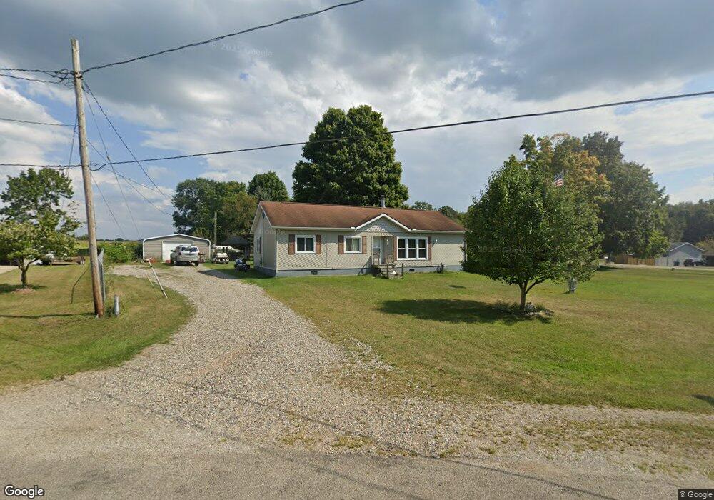
113 Wright Rd Quincy, MI 49082
Estimated Value: $163,000 - $325,000
3
Beds
1
Bath
1,260
Sq Ft
$174/Sq Ft
Est. Value
About This Home
This home is located at 113 Wright Rd, Quincy, MI 49082 and is currently estimated at $219,785, approximately $174 per square foot. 113 Wright Rd is a home located in Branch County with nearby schools including Jennings Elementary School, Quincy Middle School, and Quincy High School.
Ownership History
Date
Name
Owned For
Owner Type
Purchase Details
Closed on
Apr 30, 2009
Sold by
Spieth Lavern H and Spieth Gearldine
Bought by
Roush Jennie
Current Estimated Value
Home Financials for this Owner
Home Financials are based on the most recent Mortgage that was taken out on this home.
Original Mortgage
$88,000
Outstanding Balance
$53,996
Interest Rate
4.32%
Mortgage Type
Seller Take Back
Estimated Equity
$165,789
Purchase Details
Closed on
Apr 4, 2007
Sold by
Brown Billy R and Brown Luann
Bought by
The Bank Of New York Trust Co Na and Jpmorgan Chase Bank Na
Create a Home Valuation Report for This Property
The Home Valuation Report is an in-depth analysis detailing your home's value as well as a comparison with similar homes in the area
Purchase History
| Date | Buyer | Sale Price | Title Company |
|---|---|---|---|
| Roush Jennie | $88,000 | None Available | |
| The Bank Of New York Trust Co Na | -- | None Available |
Source: Public Records
Mortgage History
| Date | Status | Borrower | Loan Amount |
|---|---|---|---|
| Open | Roush Jennie | $88,000 |
Source: Public Records
Tax History
| Year | Tax Paid | Tax Assessment Tax Assessment Total Assessment is a certain percentage of the fair market value that is determined by local assessors to be the total taxable value of land and additions on the property. | Land | Improvement |
|---|---|---|---|---|
| 2025 | $1,388 | $66,139 | $0 | $0 |
| 2024 | $13 | $79,386 | $0 | $0 |
| 2023 | $470 | $67,139 | $0 | $0 |
| 2022 | $1,265 | $65,998 | $0 | $0 |
| 2020 | -- | $57,056 | $0 | $0 |
| 2019 | -- | $57,848 | $0 | $0 |
| 2018 | -- | $56,630 | $0 | $0 |
| 2017 | -- | $59,471 | $0 | $0 |
| 2016 | -- | $48,772 | $0 | $0 |
| 2015 | -- | $48,716 | $0 | $0 |
| 2014 | -- | $34,215 | $0 | $0 |
| 2013 | -- | $28,622 | $0 | $0 |
Source: Public Records
Map
Nearby Homes
- 944 Lukesport Rd
- 981 Generic Dr
- 201 Wildwood Beach Rd
- 211 S Ray Quincy Rd
- 808 Rolling Meadows Dr
- 181 Dons Dr
- 204 Crockett Dr
- 202 Dons Dr
- 204 Dons Dr
- 0 Wildwood Rd
- 0 Brocklebank Rd
- 242 Bickford Dr
- 727 Skipper Ln
- 8 Hunting Trail Ave
- 46 W Chicago St
- 345 N Fremont Rd
- 732 Cambridge Dr
- 14 Cole St
- 29 Broughton St
- 493 Richard St
Your Personal Tour Guide
Ask me questions while you tour the home.