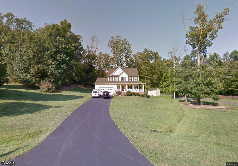
11306 Springfield Dr Fredericksburg, VA 22408
Bellvue NeighborhoodEstimated Value: $440,387 - $519,000
4
Beds
3
Baths
2,354
Sq Ft
$206/Sq Ft
Est. Value
About This Home
This home is located at 11306 Springfield Dr, Fredericksburg, VA 22408 and is currently estimated at $483,847, approximately $205 per square foot. 11306 Springfield Dr is a home located in Spotsylvania County with nearby schools including Spotswood Elementary School, Battlefield Middle School, and Massaponax High School.
Ownership History
Date
Name
Owned For
Owner Type
Purchase Details
Closed on
Jun 9, 2004
Sold by
The Charleston Company
Bought by
Brady Richard
Current Estimated Value
Home Financials for this Owner
Home Financials are based on the most recent Mortgage that was taken out on this home.
Original Mortgage
$272,550
Outstanding Balance
$133,143
Interest Rate
5.99%
Mortgage Type
New Conventional
Estimated Equity
$350,704
Purchase Details
Closed on
Oct 15, 2003
Sold by
Estel Partners
Bought by
The Charleston Co
Home Financials for this Owner
Home Financials are based on the most recent Mortgage that was taken out on this home.
Original Mortgage
$1,000,000
Interest Rate
6.43%
Mortgage Type
Construction
Create a Home Valuation Report for This Property
The Home Valuation Report is an in-depth analysis detailing your home's value as well as a comparison with similar homes in the area
Home Values in the Area
Average Home Value in this Area
Purchase History
| Date | Buyer | Sale Price | Title Company |
|---|---|---|---|
| Brady Richard | $286,944 | -- | |
| The Charleston Co | $39,000 | -- |
Source: Public Records
Mortgage History
| Date | Status | Borrower | Loan Amount |
|---|---|---|---|
| Open | Brady Richard | $272,550 | |
| Previous Owner | The Charleston Co | $1,000,000 |
Source: Public Records
Tax History
| Year | Tax Paid | Tax Assessment Tax Assessment Total Assessment is a certain percentage of the fair market value that is determined by local assessors to be the total taxable value of land and additions on the property. | Land | Improvement |
|---|---|---|---|---|
| 2025 | $3,011 | $410,000 | $87,500 | $322,500 |
| 2024 | $3,011 | $410,000 | $87,500 | $322,500 |
| 2023 | $2,561 | $331,900 | $70,000 | $261,900 |
| 2022 | $2,448 | $331,900 | $70,000 | $261,900 |
| 2021 | $2,520 | $311,300 | $52,500 | $258,800 |
| 2020 | $2,520 | $311,300 | $52,500 | $258,800 |
| 2019 | $2,458 | $290,100 | $42,000 | $248,100 |
| 2018 | $2,417 | $290,100 | $42,000 | $248,100 |
| 2017 | $2,451 | $288,300 | $38,500 | $249,800 |
| 2016 | $2,451 | $288,300 | $38,500 | $249,800 |
| 2015 | -- | $276,800 | $35,000 | $241,800 |
| 2014 | -- | $276,800 | $35,000 | $241,800 |
Source: Public Records
Map
Nearby Homes
- 309 Olde Greenwich Dr
- 232 Farrell Ln
- 226 Hillcrest Dr
- 2712 Lafayette Blvd
- 4 Jonquil Ct
- 107 Gibson St
- 121 Laurel Ave
- 2 Juniper Ct
- 4430 Hotchkiss St
- 4004 Longwood Dr
- 117 Hill St
- 1002 Martingale Ct
- 216 Lorraine Ave
- 1808 Lafayette Blvd
- 4512 Briarhaven Dr
- 114 Braehead Dr
- 1216 Hudgins Farm Cir
- 10644 Afton Grove Ct
- 10642 Afton Grove Ct
- 10640 Afton Grove Ct
- 11304 Springfield Dr
- 4201 Normandy Ct
- 4205 Normandy Ct
- 4203 Normandy Ct
- 11302 Springfield Dr
- 4209 Normandy Ct
- 4207 Normandy Ct
- 4211 Normandy Ct
- 4215 Normandy Ct
- 4217 Normandy Ct
- 11303 Springfield Dr
- 11309 Springfield Dr
- 11300 Springfield Dr
- 11310 Springfield Dr
- 4504 Alliance Way
- 4502 Alliance Way
- 4500 Alliance Way
- 11301 Springfield Dr
- 4506 Alliance Way
- 4508 Alliance Way
Your Personal Tour Guide
Ask me questions while you tour the home.