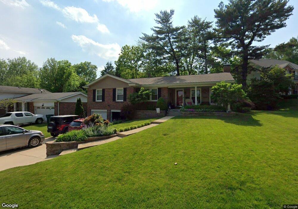
1131 Albany Ct Saint Louis, MO 63119
Estimated Value: $366,000 - $419,000
3
Beds
2
Baths
1,359
Sq Ft
$291/Sq Ft
Est. Value
About This Home
This home is located at 1131 Albany Ct, Saint Louis, MO 63119 and is currently estimated at $395,262, approximately $290 per square foot. 1131 Albany Ct is a home located in St. Louis County with nearby schools including Edgar Road Elementary School, Hixson Middle School, and Webster Groves High School.
Ownership History
Date
Name
Owned For
Owner Type
Purchase Details
Closed on
Jan 12, 2010
Sold by
Kohring Patrick C and Kohring Summer L
Bought by
Darnell John and Darnell Louise
Current Estimated Value
Purchase Details
Closed on
Dec 5, 2003
Sold by
Charow Todd R and Charow Kristin L A
Bought by
Kohring Patrick C and Kohring Summer L
Home Financials for this Owner
Home Financials are based on the most recent Mortgage that was taken out on this home.
Original Mortgage
$215,175
Interest Rate
5.94%
Mortgage Type
Purchase Money Mortgage
Purchase Details
Closed on
Jan 31, 2003
Sold by
Charow Todd R and Wilschetz Kristin L A
Bought by
Charow Todd R and Charow Kristen L A
Home Financials for this Owner
Home Financials are based on the most recent Mortgage that was taken out on this home.
Original Mortgage
$147,350
Interest Rate
4.12%
Purchase Details
Closed on
Mar 31, 1999
Sold by
Allbritton Robert M
Bought by
Charow Todd R and Wilschetz Kristen L A
Home Financials for this Owner
Home Financials are based on the most recent Mortgage that was taken out on this home.
Original Mortgage
$139,300
Interest Rate
6.37%
Create a Home Valuation Report for This Property
The Home Valuation Report is an in-depth analysis detailing your home's value as well as a comparison with similar homes in the area
Home Values in the Area
Average Home Value in this Area
Purchase History
| Date | Buyer | Sale Price | Title Company |
|---|---|---|---|
| Darnell John | $246,000 | Continental Title Company | |
| Kohring Patrick C | $226,500 | -- | |
| Charow Todd R | -- | -- | |
| Charow Todd R | $163,900 | -- |
Source: Public Records
Mortgage History
| Date | Status | Borrower | Loan Amount |
|---|---|---|---|
| Previous Owner | Kohring Patrick C | $215,175 | |
| Previous Owner | Charow Todd R | $147,350 | |
| Previous Owner | Charow Todd R | $139,300 |
Source: Public Records
Tax History Compared to Growth
Tax History
| Year | Tax Paid | Tax Assessment Tax Assessment Total Assessment is a certain percentage of the fair market value that is determined by local assessors to be the total taxable value of land and additions on the property. | Land | Improvement |
|---|---|---|---|---|
| 2025 | $4,286 | $65,280 | $31,080 | $34,200 |
| 2024 | $4,286 | $61,580 | $24,850 | $36,730 |
| 2023 | $4,286 | $61,580 | $24,850 | $36,730 |
| 2022 | $3,821 | $51,150 | $21,760 | $29,390 |
| 2021 | $3,808 | $51,150 | $21,760 | $29,390 |
| 2020 | $3,798 | $47,510 | $24,800 | $22,710 |
| 2019 | $3,776 | $47,510 | $24,800 | $22,710 |
| 2018 | $3,631 | $40,560 | $15,520 | $25,040 |
| 2017 | $3,607 | $40,560 | $15,520 | $25,040 |
| 2016 | $3,106 | $33,390 | $10,870 | $22,520 |
| 2015 | $3,110 | $33,390 | $10,870 | $22,520 |
| 2014 | $3,364 | $35,170 | $9,770 | $25,400 |
Source: Public Records
Map
Nearby Homes
- 107 Saint George Place
- 12 Webster Acres
- 26 Webster Oaks Dr
- 30 Webster Oaks Dr
- 52 Webster Acres
- 1330 Drayton Ave
- 308 Oak Tree Dr
- 312 Oak Tree Dr
- 134 Firwood Dr
- 147 Firwood Dr
- 725 Brookridge Dr
- 907 Edgar Rd
- 1509 Holly Dr
- 432 Reavis Place Unit 20
- 8261 Watson Rd
- 514 S Gore Ave
- 1139 Hawken Place Unit 6
- 8509 Grantshire Ln
- 1316 Webster Forest Ct
- 1405 Culverhill Dr